Australia map
https://oir.mobi/627515-poberezhe-avstralii.html
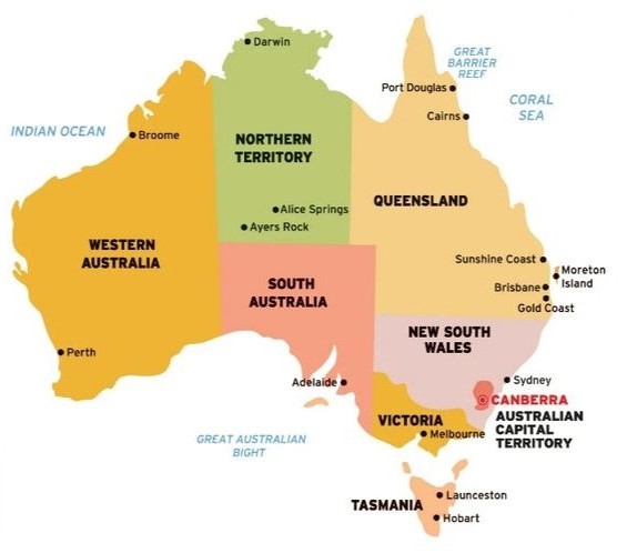
Australia (officially the Commonwealth of Australia) is the only state in the world that occupies an entire continent. The country is located in the Southern Hemisphere and encompasses mainland Australia, the island of Tasmania and several other small islands (32,163 km²). The Commonwealth of Australia is the sixth largest in the world, occupying 5% of the land on Earth (total area of about 7.7 million km ²). The population is 25.1 million inhabitants, the bulk of which is concentrated on the east coast. The average population density is 3.27 people / km². The capital is the city of Canberra.
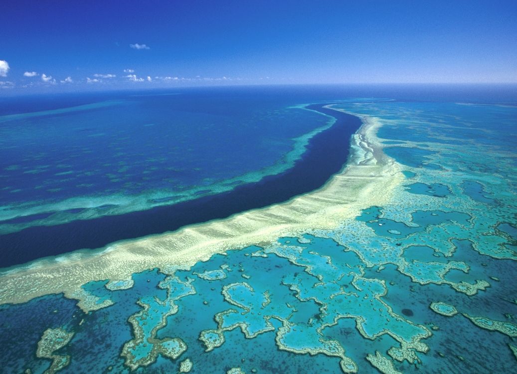
On the western and southern sides, the territory of the state is washed by the waters of the Indian Ocean, and on the northern and eastern sides: by the seas of the Pacific Ocean (Tasmanovo, Koralovoye, Arafurskoye). The length of the coast is 59.7 km, of which 35.8 km is the coast of the mainland. The Great Barrier Reef is the world's largest coral reef, stretching for more than 2 thousand km along the northeastern coast.
Australia is the driest continent without glaciers and active volcanoes. Lowlands, semi-deserts and deserts dominate (Great Victoria Desert, Great Sandy Desert, Great Artesian Basin, etc.).
The maximum height is Mount Kosciuszko (2228 m), the lowest point is Lake Eyre with an area of 15,000 km² (-15 m from sea level). The peculiarities of the geographical location and age of the continent influenced the formation of the biota of Australia: out of 12 thousand species of flora and fauna, 9 thousand are endemic, and this is the majority of mammals, coastal fish, flowers and almost half of the birds. The country's unique biosystem is protected (16 sites are included in the World Heritage List).
One of the richest natural resources countries holds leading positions in reserves of uranium, bauxite, zirconium, coal, but has problems with freshwater (official restrictions have been introduced).
Australia is located in 4 climatic zones: subequatorial, tropical, subtropical and temperate.
The territory of the state is located in three time zones:
- Eastern Standard Time UTC + 10;
- Central Standard Time UTC + 9: 30;
- Western standard time UTC + 8.
Australia has the second highest human development index in the world (0.93), a developed economy with a GDP of 1.387 trillion dollars, and ranks high in the world in terms of quality of life.
The economy is based on agriculture (sugar cane, wheat, nuts, fruits, vegetables, opium poppy for pharmaceuticals, wool production), chemical, metallurgical, and automotive industries.
The Commonwealth of Australia is a member state of the British Commonwealth of Nations and Queen Elizabeth II is formally the head of state, represented by the governor in each state.
Coordinates: 25°S, 135°E
Regions of the country
http://www.bolshoyvopros.ru/questions/3413477-kak-nazyvaetsja-stolica-avstralii-kanberra-sidnej-brazzavil.html
The administrative division of Australia is represented by:
- 6 states,
- 2 mainland territories.
All administrative-territorial units have: their own legislative body; governors and administrators (territories) who represent the queen; heads of government (prime ministers in the states, chief ministers in the territories).
States:
- Western Australia. Occupies 1/3 of Australia's territory and is the largest state in Australia (area 2.64 million km ²). In terms of area, the state also ranks second in the world among the largest administrative units, second only to the Republic of Sakha (Yakutia). Population: 2.6 million people. The capital is the city of Perth. Administrative divisions: 10 districts. The basis of the economy: mining and processing of minerals and oil, agriculture, tourism, fishing.
- Victoria. The smallest state (area 227 thousand km²) is located in the southeast of the country. The population is about 5.4 million people. The capital is the city of Melbourne. Administrative divisions: 79 municipalities (39 counties, 32 cities, 7 rural towns and 1 borough). The state's economy ranks second in Australia. Economic base: finance, real estate and insurance.
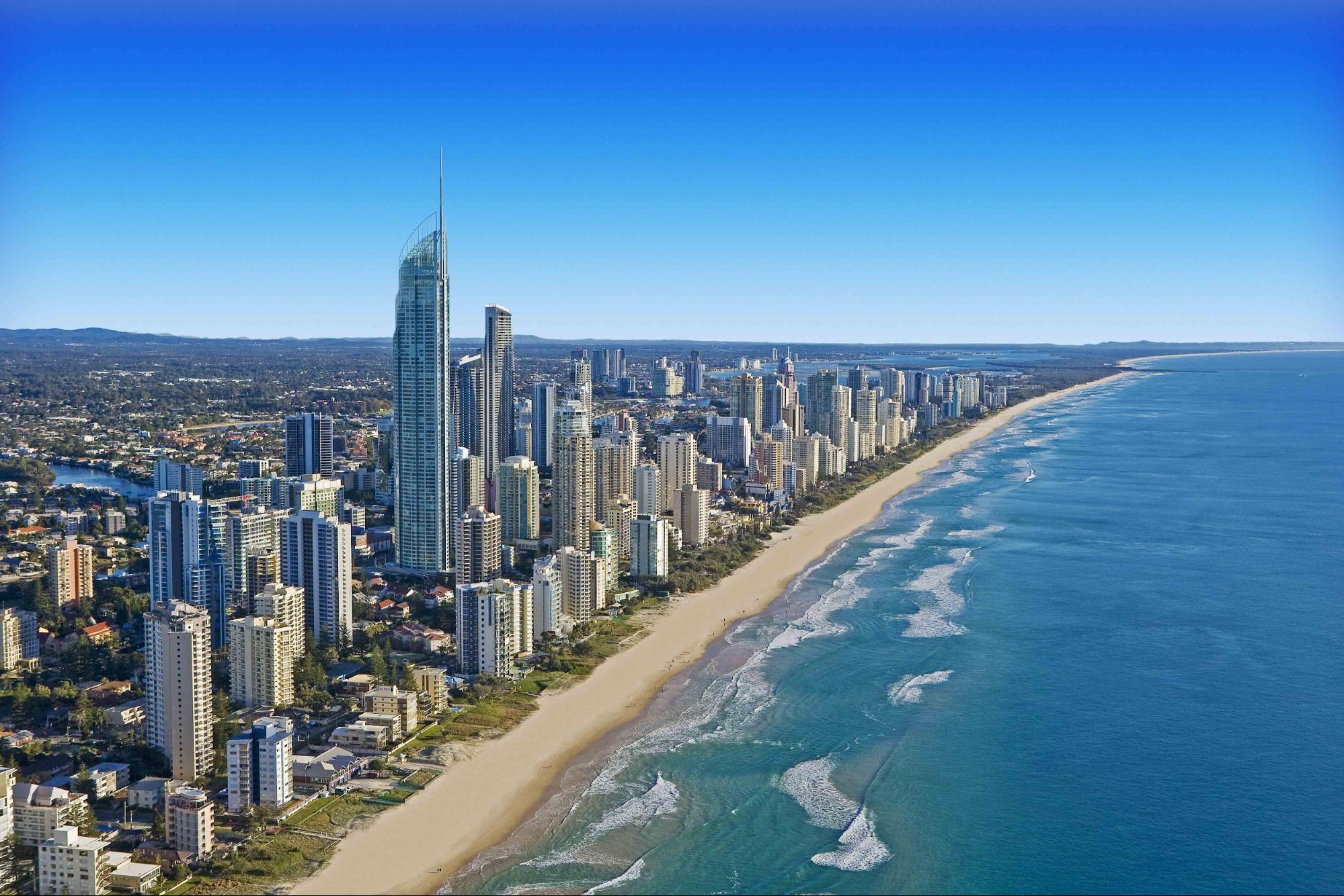
- Queensland. State located in the northeast of the island of Australia (an area of 1.7 million km²). Population is 5.2 million. The administrative center is the city of Brisbane. Divided into 11 major geographic regions and 3 smaller ones. Rich in nature and landscapes. It has 5 protected areas of World Heritage Sites (Great Barrier Reef, Wet Tropics, East Central Rainforest Reserve, Australian Mammal Fossil Sanctuary, Fraser Island). Economic dominants: growing fruits and vegetables, winemaking, animal husbandry, cotton, sugarcane, wool production, mining of coal, silver, lead, copper and gold, as well as tourism.
- Tasmania. State with a population of 534 thousand people is located on the island of the same name with an area of 68.4 thousand km ². The capital is the city of Hobart. Washed by the Indian and Pacific Oceans. It is separated from the mainland by the Bass Strait. 44% of the territory is rainforest (21% are national parks). The state has a unique flora and fauna: most of the representatives are endemic. The economy is built on mining, agriculture, tourism and logging.
- New South Wales. The oldest and most populous state (population is 8.15 million) located in the southeast of the country. The area is 809.4 thousand km ². The capital is the city of Sydney. The state has more than 780 national parks and protected areas (8% of the territory). The backbone of the economy: agriculture, new technologies, financial services, coal mining, tourism.
- South Australia. State occupies the central driest part of Australia with an area of 983.5 thousand km². The state has a population of 1.6 million people. The administrative center is the city of Adelaide. State economic foundation: agriculture, mining, finance, automotive, metalworking. The main branches of agriculture are: winemaking, growing grain crops, and sheep breeding.
Mainland territories:
- Northern territory. Located in the north of mainland Australia (an area of more than 1.3 million square kilometers, a population of about 212 thousand people). The capital is the city of Darwin. Administrative divisions: 17 local government districts (11 counties, 5 municipalities)
- The Australian Capital Territory (ACT) is the smallest area (about 2.4 thousand km²). It includes: the capital city of Canberra, Namadgi National Park (46% of the ACT area) and an agricultural zone. Population: 427 thousand people. Allocated by the state of New South Wales in 1901 specifically for the construction of the capital.
The most interesting sights
Great Barrier Reef
https://glas.ru/society/ecology/53044-zakislenie-okeana-vyzyvaet-korallovyj-osteoporoz-na-znamenityh-rifah.html
The world's largest coral reef is located in the waters of the Pacific Ocean. It is located along the northeastern coast of Australia for 2500 km. Scientists believe that its age is no more than 400 thousand years. The ridge of more than 2900 coral reefs (from 0.01 km² to 100 km²) covers an area of 344.4 thousand km², most of which are covered with water. Reef islands are subdivided into: continental, coral, mangrove.
The Great Barrier Reef is the world's largest colony of coral polyps, whose vital activity has become the reason for the appearance of this reef, which no longer has any equal on the planet. It is called one of the seven natural wonders of the world, and in 1981 UNESCO recognized it as a World Heritage Site.
The waters surrounding the Great Barrier Reef are inhabited by about 1.5 thousand species of fish (whale shark, parrot fish, moray eels, butterfly fish and many others), 3 thousand mollusks, 500 species of worms, 100 species of jellyfish. The South Reef Islands are home to 6 endangered sea turtle species. And on the islands closest to the mainland, more than 240 species of birds nest. The flora is represented by only 40 species.
The northernmost island of Lizard is called the island of the lizards because of the large number of monitor lizards.
Heron Island is located in the south of the reef and is considered the best diving center in the world. Numerous herons live on this island.
Fitzroy Island belongs to a national park and is one of the wildest parts of the Great Reef.
All human activities here are under strict control, as the coral reef ecosystem is very fragile and vulnerable. The water area is divided into 6 accessibility zones. Oil and gas extraction, commercial spearfishing, any mining operations are prohibited throughout, and a common use zone that unites more than 100 islands has been set aside for fishing, shipping, coral trade and tourism.
Location: Australia
Coordinates: 18°17′10″S, 147°42′00″E
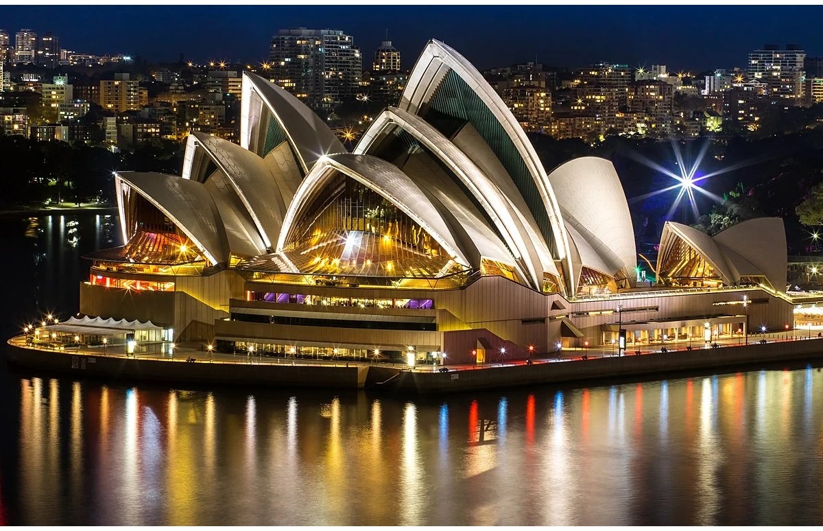
Sydney Opera House
https://portret-like.ru/product/sidneyskaya-opera/
The Sydney Opera House is one of the world's most recognizable architectural structures. The symbol of Australia's largest city, Sydney (New South Wales). It was built in 1973 in Port Jackson Harbor at Bennelong Cape. In 2007, the architectural masterpiece was included in the UNESCO World Heritage List.
The opera house is popular not only among art connoisseurs (more than 1 million people attend performances a year), but also among those who admire original solutions in architectural design (the construction itself is visited by about 10 million people a year). The building of the Sydney Opera House has no analogues in the world:
- The area of the structure, surrounded on three sides by water, is 1.8 hectares (its length is 185 m, and its width is 120 m).
- The roof, 67 m high, resembles sails with its complex structure.
- 100 rooms decorated with wood and pink granite.
- Concert Hall (2679 spectators) with the world's largest mechanical organ, Opera Theater (1507 spectators),
- Drama Theater (544 seats), Game Hall (394 seats).
- In front of the building there is a stage for 6,000 spectators.
The Sydney Opera House hosts around 3,000 performances a year, from theatrical miniatures to major festivals.
Location: Sydney NSW 2000, Bennelong Point, Australia.
Coordinates: 33°51′25″S, 151°12′54″E
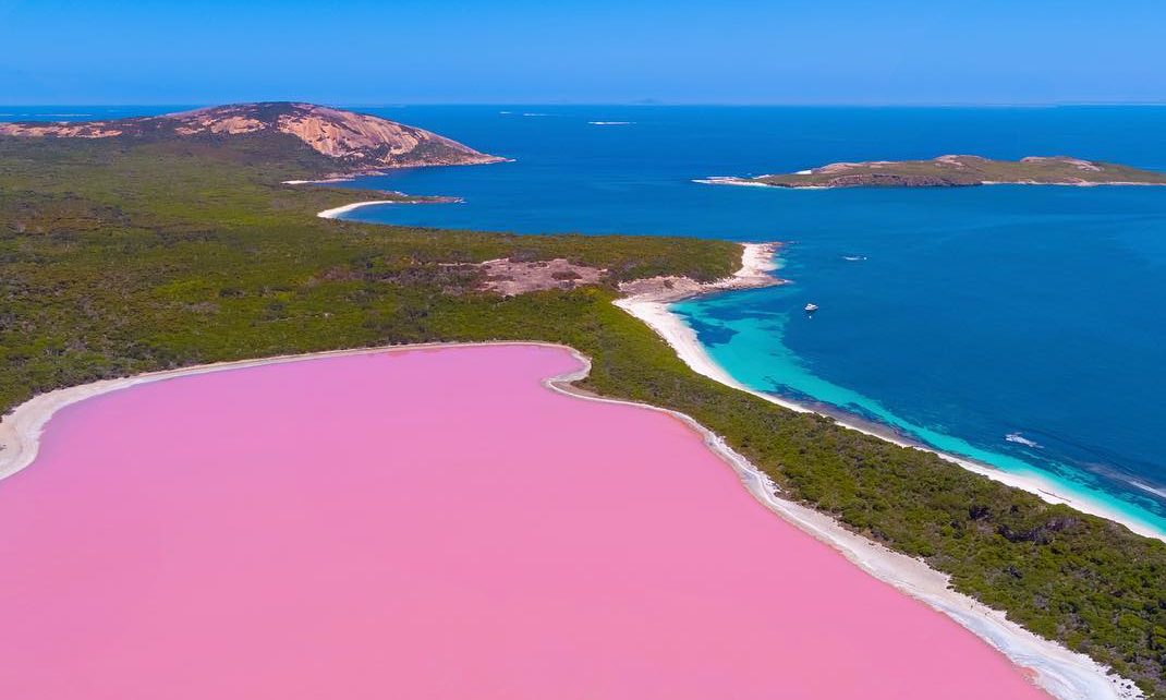
Hillier Lake
https://www.backpackerjobboard.com.au/job-news/australias-most-spectacular-lakes-to-visit/
One of the most amazing and unusual lakes on Earth is Lake Hillier. It is located on the largest uninhabited island of the Riverne archipelago, Middle Island (Western Australia, Indian Ocean).
The pink salt water lake is only 600 m long and 250 m wide (area about 1.5 hectares). The color of the water practically does not change all year round. Numerous studies in search of an explanation for such an unusual color of water only bore fruit in 2016: the reason lies in the presence of Dunaliella brackish algae and some species of unicellular organisms that can exist in very salty water.
The lake is surrounded by a strip of sand and eucalyptus forest. The coastline is bordered by white salt deposits that contrast effectively with the water.
The world famous landmark is difficult to reach for tourists, as the only way to get to it is by expensive air transport. Therefore, very few people can see this unique lake with their own eyes and get vivid impressions.
The best time to visit is the Southern Hemisphere summer (December-February).
Location: Middle Island, Western Australia 6450, Australia
Coordinates: 34°05′45″S, 123°12′10″E
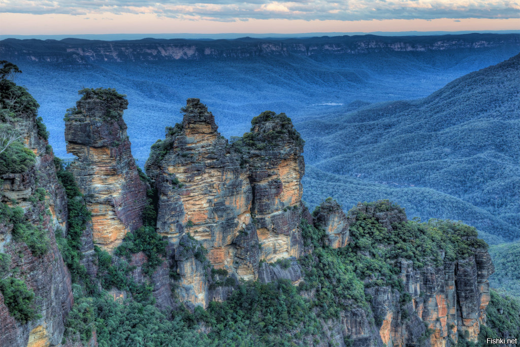
Blue Mountains
https://travel-trip.ru/puteshestviya/progulka-po-sidneyu/
The Blue Mountains are part of the Great Dividing Range, which stretches along the east and southeast coast of Australia. The mountains are located in New South Wales on the border of the city of Sydney. The maximum height is 1360 m above sea level. The mountain plateaus are indented with many canyons that add splendor to the landscape: their depth ranges from 300 to 800 m.
The Blue Mountains got their name because of a unique optical phenomenon: the refraction of light in the vapors of essential oils from numerous eucalyptus trees (90 species of eucalyptus trees grow in the area of the mountains). A bluish haze of bluish hue envelops the mountains, creating a unique atmosphere of mystery.
The main settlement is the small town of Katoomba (at an altitude of just over 1000 m above sea level). In the past it was the capital of miners. Today it is famous for its surroundings, where interesting natural objects popular with tourists are concentrated (caves, beautiful waterfalls, etc.). But the main attraction of Katoomba is the old mountain railway with the steepest rise in the world (50.7 °).
In the eastern part of the state, there is a system of national parks of the Great Blue Mountains with a total area of about 11 thousand km². The system includes 7 national parks and one special area:
- In the western part there is the oldest national park Blue Mountains with an area of 2481 km² (97 thousand hectares). The park was opened in 1959. Here are: the pearl of the Blue Mountains - Wentworth Falls, Echo Gorge and the famous Three Sisters cliffs, to which leads a staircase (more than 800 steps). More than 1 million people visit the park annually.
- Kanangra-Boyd National Park (1969)
- Thirlmere Lakes (1972). Located 100 km west of Sydney. Highlights include the 150-meter Kanangra Falls and the Sheer Kanangra Walls.
- Wollemi (1979). The only known place where one of the rarest and oldest plants in the world grows, the wollemia coniferous tree.
- Yengo (1988). Located in the Lower Hunter region. Mount Yengo is a shrine to the indigenous tribes.
- Nattai (1991). Located in the Nattai Valley.
- Gardens of Stone (1994). Located 125 km northwest of Sydney city center. Picturesque landscapes with cliffs, sheer cliffs and canyons.
- and a special area. The Jenolan Caves Karst Conservation Reserve (Jenolan Caves).
Location: New South Wales, Australia
Coordinates: Coordinates: 33°43′05″S, 150°18′38″E
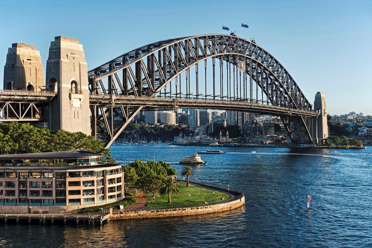
Sydney Harbour Bridge
https://puteshestvyie.ru/sidney
The Harbor Bridge was built in 1932 in the center of Sydney and is the largest bridge in the city, as well as one of the largest arched bridges in the world. The total length is 1149 m, the length of the main span is 503 m, the width is 48.8 m, and the height is 134 m. Two paired 100-meter towers with granite cladding support a steel bridge on the banks. One of the towers houses a museum and visitor center, the other houses the NSW Highway Administration. Residents of the city called the bridge “hanger” because of its external resemblance.
The Harbor Bridge plays an important role in transport links: more than 200 thousand vehicles pass through it every day. In addition, there is railway, bicycle and pedestrian traffic. Such an important place in Sydney is always involved in significant national holidays and events. For the past 20 years, a New Year's pyrotechnic show has been held on the bridge.
Harbor Bridge is one of the top 5 most visited attractions in Australia. For the bravest, there is an opportunity in special equipment to climb 1322 steps to the upper arch, from which a magnificent panorama of the city opens.
Location: 3 Cumberland Street, The Rocks, Sydney NSW, Australia
Coordinates: 33°51′08″S, 151°12′38″E
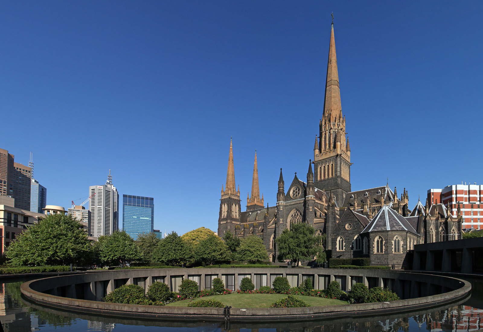
St Paul's Cathedral
https://ru.advisor.travel/city/North-Eltham-75879
St. Paul's Cathedral is located in Melbourne, Victoria. It is one of the largest Anglican cathedrals in Australia. At the time of construction, the cathedral was the tallest building in Melbourne. But the construction dragged on for almost half a century and ended only in 1926. The iconic building is made in the Gothic style of sandstone. It was specially brought from the state of New South Wales, giving it a distinctive feature from other buildings in the city: the warm yellow-brown tint of the walls. The spire of the cathedral, which was the last to be erected, ranks second in height among Anglican churches in the world. The total height of the cathedral with a spire is 95 m.
The interior of the spacious rooms is decorated with columns, arches, stained glass windows and mosaics.
A unique 6500 pipe organ by the famous T.S. Lewis of Brixton was brought from England, and today is considered one of the finest surviving works of the master.
Paul's Cathedral is visited not only by believers, but also by tourists who want to enjoy the powerful sound of an ancient organ and touch the history of Melbourne.
Location: Flinders Ln & Swanston St, Melbourne VIC 3000, Australia
Coordinates: 37°49′01″S, 144°58′01″E
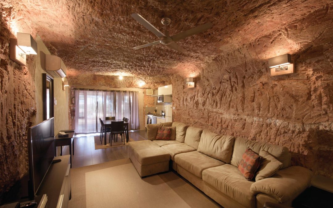
Coober Pedy
https://www.cakapcakap.com/coober-pedy-kota-bawah-tanah-di-australia-dengan-view-menakjubkan/
Coober Pedy (from aboriginal term kupa-piti, "whitefellas' hole") is a small mining town in the state of South Australia with a population of about 1.7 thousand people. The city was founded in 1915 on the eastern border of the Australian Victoria Desert, on the Stewart Ridge.
This place is the richest deposit of opals (it’s share is 30% of the total reserves in the world), therefore Coober Pedy gained fame as the “World capital of opals”. In 1956, the largest nugget in the world was found here: the Olympic Australis Opal (weight 17 thousand carats = 3.45 kg)
The peculiarity of the city is that it is mostly underground. Neighbouring the desert entailed bad weather conditions (high temperatures, sandstorms), so houses were cut down in the mountain at a depth of 2.5 to 6 meters with an exit directly into the mine. “Roofs,” as unusual as houses, are ventilation systems on the ground.
Today, the opening of new mines is prohibited, and already almost half of the city's residents live in ordinary houses.
Coober Pedy is located in one of the driest areas in Australia. There is no natural source of water here, and rains are extremely rare. Plumbing saves the day, but water is very expensive for residents. The vegetation is represented by rare low shrubs and cacti.
In addition to unusual dwellings, tourists are interested in the underground hotel, museum, churches and cemetery. On the outskirts of the city there is the world's longest livestock fence, Dingo's Fence (5.6 thousand km long).
You can get to the underground city from the city of Adelaide by bus or by plane of a local airline.
Location: Coober Pedy, South Australia 5723, Australia
Coordinates: 29°00′50″S, 134°45′18″E
Major airports in Australia
Australia has 448 officially registered airports, including major international airports and agricultural runways. The largest international airports serve flights from 144 countries of the world.
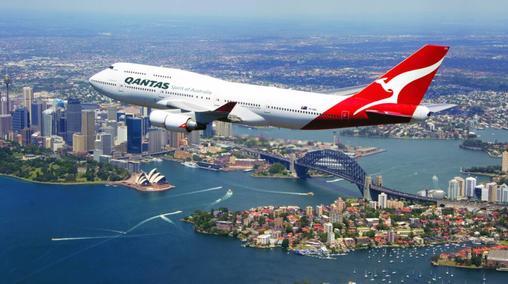
The leading airlines in Australia are:
- Qantas. International transportation;
- Jetstar. Domestic air transportation;
- Virgin Australia. domestic flights (plus Oceania and New Zealand).
http://topsweet.ru/samye-bezopasnye-aviakompanii-mira-v-2019-godu-top-20/bezopasnye-aviakompanii-qantas/
|
|
|
|
|
|
|
|
|
|
|
|
|
|
|
|
|
|
|
|
|
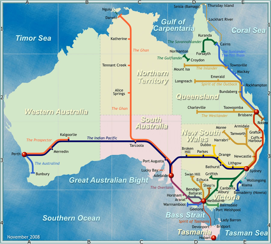
Major train stations in Australia
The first horse-drawn railway was built in South Australia in 1854, and the first steam locomotives appeared in 1856. Today Australia's rail network is 33,819 km long. The most developed network is around major cities: Brisbane, Melbourne, Sydney and others. Some plots are privately owned (transporting iron ore to the port, timber to sawmills, sugarcane to sugar factories), but most of the rail infrastructure is government or state owned.
The active development of highways led to a reduction in the length of the railway track in the period of 1946-1990. The length of railways was reduced by 5 thousand km.
Only 2,540 km of the railroad have been electrified.
http://www.carte-du-monde.net/pays/australie/carte-ferroviaire-australie.jpg
|
|
|
|
|
|
|
|
|
|
|
|
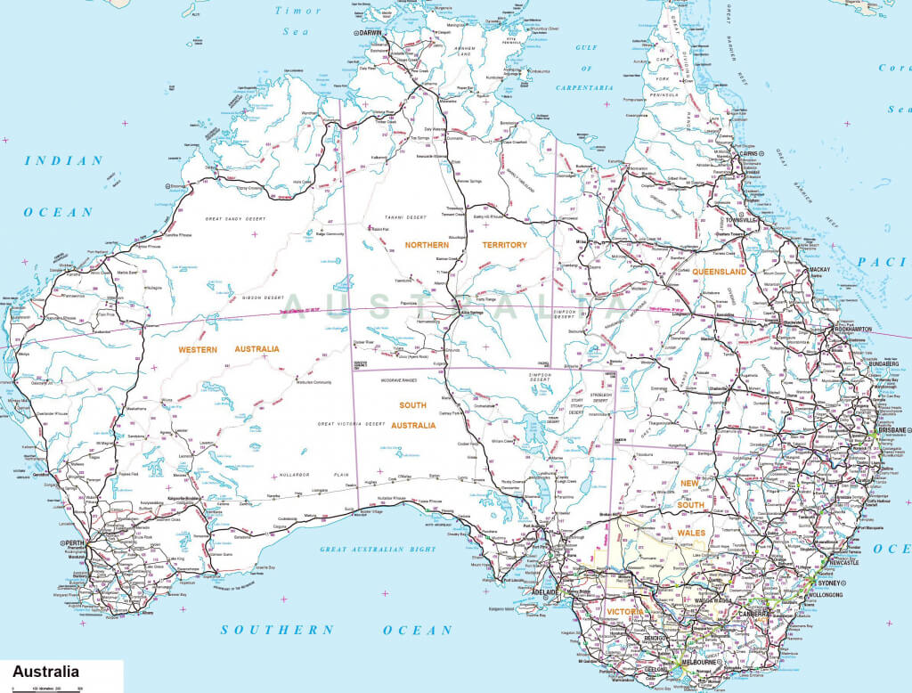
Highways of Australia
In Australia, highways play a very important role. The roads are well thought out, comfortable, with good visibility and of very good quality, therefore, road transport in the country is one of the most demanded. The total length of the road network is 913,000 km (about 350 thousand km with hard surface, and about 60 thousand km unpaved).
According to statistics, Australia ranks second in the world in terms of the number of cars per person and the third in terms of gasoline consumption and average distances travelled by car. Left-hand traffic is accepted in the country.
Australia's road system is as follows:
- federal roads;
- state roads;
- local roads.
The oldest road in Australia is the Great Ocean Road, 243 km long. The road runs mainly along the coast, through a beautiful rainforest, vineyards. It is a local attraction.
https://magnetsimulatorcodes.com/printable-map-of-australia/australia-maps-printable-maps-of-australia-for-download-with-printable-map-of-australia/
Editor's Choice: Whitehaven Beach
https://awayandfar.com/15-best-beaches-in-australia/
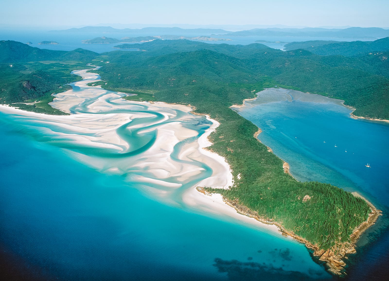
In 1879, British naval officer E. P. Bedwell on the northeast coast of Queensland discovered one of the most beautiful places in Australia: Whitehaven Beach (White Harbor, White Paradise). This beautiful beach is located on the largest of the 74 islands of the Holy Trinity archipelago, White Sunday (Holy Trinity Island) and has a length of 7 km.
The white sand of the wild beach is almost 100% silica, which is brought by the tides from the dying coral islands. Even at the highest temperatures, the sand never gets hot. The dazzling white and pleasant to the touch quartz sand of the beach is considered a natural phenomenon. The smallest grains of sand are used in glass production and silver polishing.
White Sunday Island is located behind the Great Barrier Reef, therefore it is reliably protected from the winds. The weather is constantly warm here (26-28 degrees).
In the north of the beach is the striking color contrast of the Hill Inlet bay: bright white sand enhances the turquoise color of the clear water. The most convenient place for observing the “sand eddies” of Hill Inlet Bay is the Tongue Point observation deck.
Whitehaven Beach is recognized as the cleanest and most ecological beach in the world. The territory of the coastline of the island is in the status of a national park. This is a place for those who love the pristine and true beauty of nature.
There is no infrastructure on the island. You can stay overnight in a tent camp only with a permit. Therefore, most tourists stay in hotels on the neighboring island of Hamilton. It offers tourists snorkeling, scuba diving, rafting, kayaking, jet skis and seaplane flights. Visiting the island will be most comfortable in May and September, when solar activity is not too high.
Location: 4802, Queensland, Whitsunday Islands, Australia
Coordinates: 20°16′43″S, 149°02′11″E