Canada map
https://evo-rus.com/avto/exluzive/uchenye-sravnili-spermatozoid-so-shtoporom-i-vydroj.html
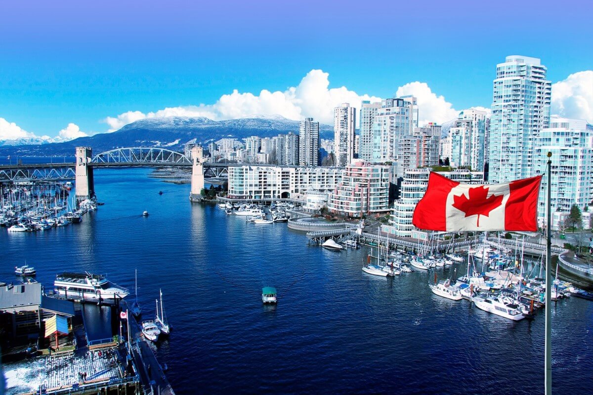
Canada is one of the largest countries in the world, occupying most of the North American continent (territory 9 984 670 km², of which 8.62% is the water surface). In terms of area, Canada ranks second in the world. The multicultural state is inhabited by just over 37.6 million people, with one of the lowest population densities (3.76 people / km²). The country has two official languages: English and French. The capital is Ottawa.
The territory of Canada is washed by three oceans (the Arctic, Pacific and Atlantic), which makes it the absolute leader in the world in terms of the length of the coastline. And leadership is not only about this. In Canada there are:
- the world's largest source of fresh non-freezing water (Great Lakes);
- the St. Lawrence River has the largest estuary in the world;
- Bay of Fundy is famous for the world's highest tides;
- Hudson Bay is the second largest in the world;
- Bordering Northern Canada, the Canadian Arctic Archipelago includes the largest islands in the world.
The relief is presented mainly as a hilly plain. There are mountain ranges up to 2.7 km high (Canadian Cordilleras, Appalachians, Notre Dame massif). Canada is one of the largest producers of mineral raw materials (nickel, zinc, uranium, copper, platinum).
A rich and varied fauna, in the forests there is a pronounced predominance of conifers. Forests cover 45% of the country's territory.
The climate in the country is extremely diverse, as it stretches over 6 time zones:
- North American Pacific Time, UTC -8;
- mountain time, UTC -7;
- central time UTC -6;
- North American Eastern Time, UTC -5;
- Atlantic time is UTC -4 and UTC -3: 30.
The country's territory conditionally has cold (arctic and subarctic climate) and warm zones (temperate climate). The lowest temperature in the entire history of Canada was in the Yukon (-63 ˚C), and the snow cover in Quebec reached more than 3 meters. In Vancouver, summer temperatures reach 40 ° C.
Canada is a constitutional monarchy with a parliamentary system. According to the form of government, it is a federation with administrative division into 10 provinces and 3 federal territories. It is included in the group of the leading economically developed countries of the world.
Coordinates: 56°N, 109°W
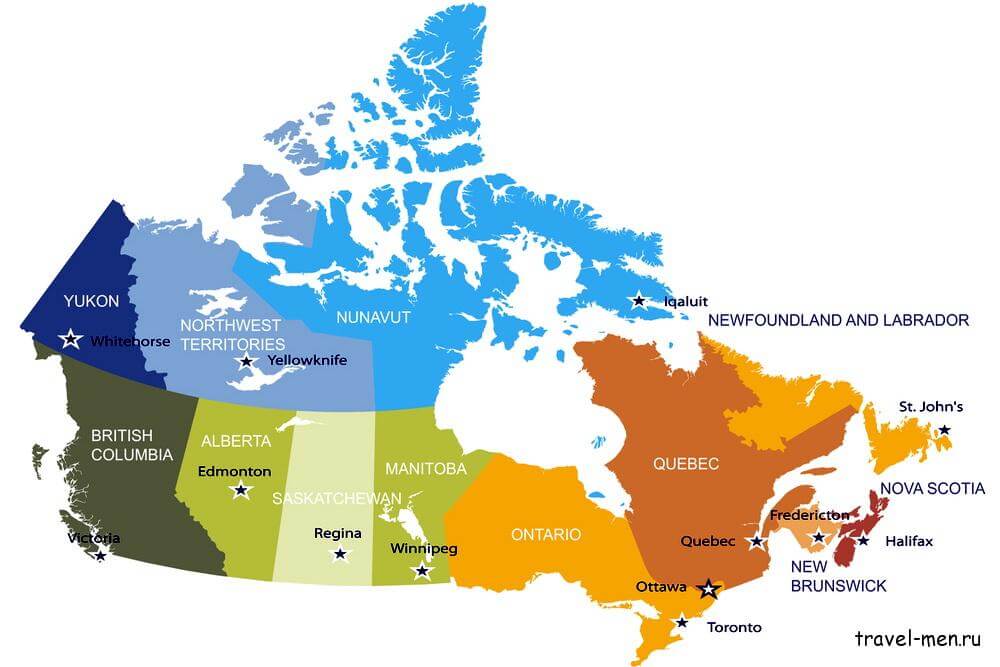
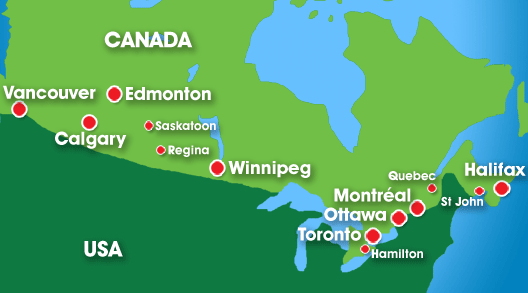
Regions of the country
The provinces of Canada are sovereign administrative units. Their existence is written into the constitution. Today Canada consists of 10 provinces: Alberta, Quebec, British Columbia, Ontario, Manitoba, New Brunswick, Nova Scotia, Newfoundland and Labrador, Prince Edward Island, Saskatchewan. Each province has its own government, parliament, its own budget and its own courts, as well as a lieutenant governor, who is the representative of the queen.
https://travel-men.ru/kak-pereekhat-v-kanadu/
- Ontario. The most populous province (over 12.8 million inhabitants) and the second in area (just over 1 million km²). Located in the center of the country. Toronto is the capital of Ontario and largest city in Canada. The country's capital, Ottawa, is also located in Ontario. This is the edge of the expanses of rivers and lakes: ⅓ of the world's fresh water reserves are located here. The province of Ontario is also the economic foundation of the state (52% of all industrial production). The production of vehicles, steel, paper, chemicals is developed.
- Quebec. Province is located in the east of the country and is the leader in terms of area (1,542,056 km ²) and ranks second in terms of population (7.9 million people). The capital is Quebec City, and the largest city is Montreal. 3% of all the world's renewable water reserves are located in Quebec. (more than half a million lakes, 4.5 thousand rivers). The economy is based on biotechnology, pharmaceuticals, metallurgy, culture and information technology, aerospace and timber mining.
- British Columbia. Located in the west of the country. The third in terms of population and area (4.4 million inhabitants per 9.4 thousand km ²). The capital is Victoria. The metropolis Vancouver with a highly developed film industry is the third largest city in Canada. Agriculture is developed, the economy is based mainly on natural resources. On the coast of the province are the largest ports in the Pacific region.
- Newfoundland and Labrador. The largest of the provinces of Canada on the side of the Atlantic Ocean (area 405 thousand km², population 528.3 thousand people, of which 95% live on the island of Newfoundland). The capital is the city of St. John's. The province is famous for the world's largest iron ore deposit on the Labrador Peninsula and the proximity to the richest fishing zone in the World Ocean — the Great Newfoundland Bank.
- Alberta. Located in the western part of Canada (an area of about 662 thousand km², a population of 4.2 million people). The capital is the city of Edmonton. The province's economy is one of the most developed and strongest in Canada with the highest level of freedom. GDP per capita has the highest rates. The basis of the economy: the oil industry (the country's largest producer of oil and synthetics is in the top 3 exporters of natural gas), agriculture, and new technologies.
- Prince Edward Island. The smallest in terms of area (5660 km²) and population (about 147 thousand people). The capital is Charlottetown. The island with very fertile land is connected to the mainland by a bridge. The economy is based on agriculture (potato growing), fishing and tourism.
The Canadian Territories (Nunavut, Northwest Territories and Yukon) are administered by the Canadian Federal Parliament.
- Nunavut. Area just over 2 million km², population 33.6 thousand people. It is the largest and most sparsely populated territory of Canada with the lowest population density in the world (0.015 people / km²). The main language is Eskimo;
- Northwest Territories. North of the country, circumpolar region, area 1.3 million km², population 41.5 thousand people. Minerals, the country's largest diamond deposit;
- Yukon. North-west of the country, area 482.4 thousand km ², population 33.8 thousand people. The second highest mountain in North America — Mount Logan, and minerals. Land development began with the famous Gold Rush.
The most interesting sights of Canada
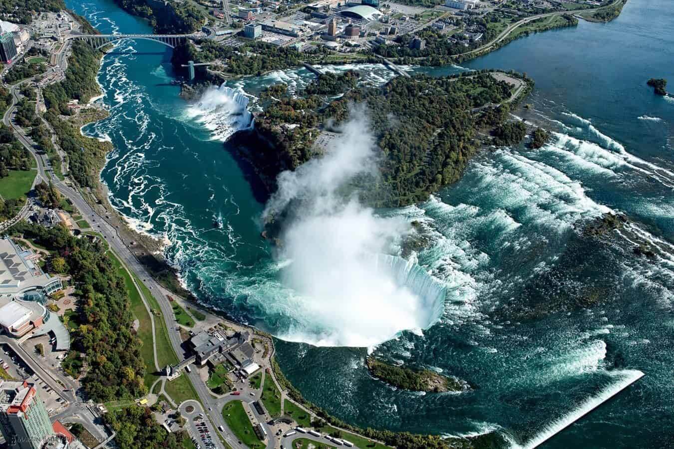
Niagara Falls
https://waterfal.ru/niagarskij-vodopad/
Niagara Falls is one of the most impressive natural wonders in North America, located on the border of Canada and the United States. Interesting fact: the city in the USA and the city in Canada, located next to the waterfall, in both countries are named the same — Niagara Falls. The first mentions of this amazing waterfall date back to the beginning of the 17th century. The Niagara River, on which Niagara Falls is located, connects Lakes Erie and Ontario, which are part of the Great Lakes of North America.
The large-scale Niagara Falls is a complex of three waterfalls (cascades) that have their own name. From the side of Canada there is a waterfall Horseshoe (Canadian Falls), from the American side — the waterfalls American (width 323 m) and Veil. The width of the Horseshoe is 792 m. It is the widest and most spectacular of Niagara falls, and 90% of the total water volume passes through it. Water falls from a height of 53 meters. Translated from the language of the Indians, Niagara means the rumble of water.
In 1885, the Queen Victoria Niagara Falls Park was founded to preserve a unique natural phenomenon.
The energy of the water flow is efficiently used to generate electricity. Sir Adam Beck 1 and Sir Adam Beck 2 are the most powerful power plants on the Niagara River on the Canadian side. 50% to 75% of the total volume of water through the four tunnels is diverted upstream, passes through hydroelectric turbines and returns to the river below the falls.
Below the waterfalls across Niagara is the graceful Rainbow Bridge, which connects Canada and the United States.
The waterfall is beautiful at any time of the year, so millions of tourists do not miss the opportunity to see its indomitable strength and amazing beauty with their own eyes.
Location: Niagara Falls ON L2G 3L7 Ontario, Canada.
Coordinates: 43°04′41″N, 79°04′33″W
CN Tower, Toronto
https://funart.pro/3447-si-jen-taujer-telebashnja-kanada-25-foto.html
The CN Tower is a visiting card of Toronto (Ontario). This graceful spire with a height of 553.3 meters retained its leadership in the world as the tallest free-standing structure, until 2007. But today, for the Western Hemisphere, the CN Tower remains the tallest unsupported structure. The construction of this telecommunications tower took 2 years and was completed in 1975.
- 147 floors, the upper floor of which is at a height of 446.5 m, are served by 9 elevators (speed 6 m / s). The 4 visitor lifts are equipped with a glass wall, allowing you to observe a wonderful view.
- At an altitude of 351 m, there is a Skypod, a round "capsule" with viewing galleries, a revolving restaurant "360", a nightclub and a photo exhibition dedicated to the construction of the TV tower. The main observation deck is equipped with a partially glazed floor.
- EdgeWalk attraction (height 356 m): passage on an open platform 1.5 m wide (with a safety rope).
- The highest in the world observation deck Space Deck at an altitude of 447 m, which not everyone dares to climb.
- The staircase leading to the upper floors has 2,570 steps.
- The tower is equipped with a lighting system: red and white lighting (colors of the national flag).
The Canadian “Wonder of the World” is visited by about 1.7 million guests annually.
Location: 301 Front Street West Toronto, Ontario M5V 2T6, Canada
Coordinates: 43°38′33″N, 79°23′13″W
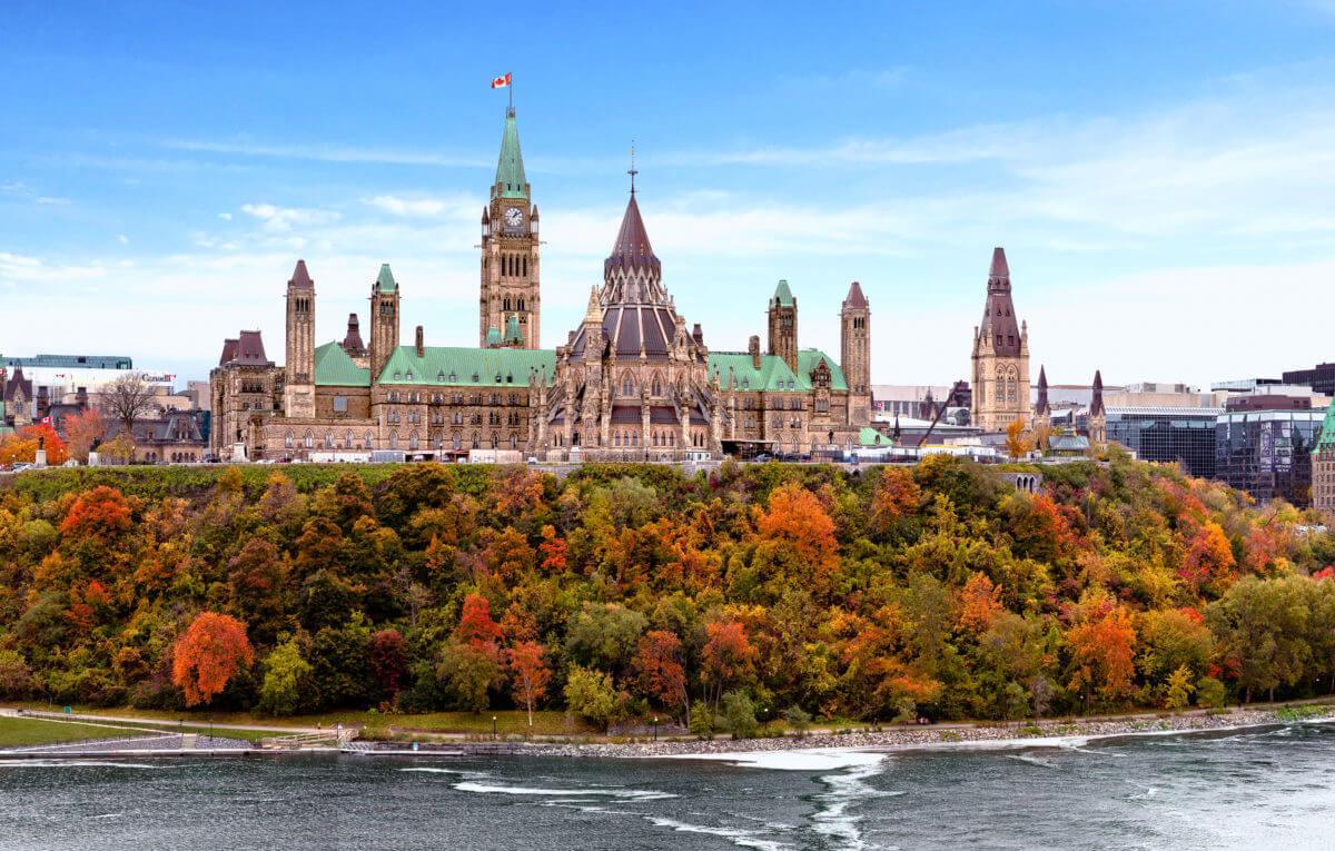
Parliament Hill, Ottawa
https://www.immigration.ca/ottawa-aims-to-help-canada-employers-hire-visitors-with-temporary-policy-change
Parliament Hill is located in the heart of the Canadian capital on the south bank of the Ottawa River. Construction of the Parliament Building began in 1859, but a fire in 1916 destroyed all buildings except part of the Parliamentary Library. Today it is a large architectural complex of state buildings in the neo-Gothic style with an area of 88.5 thousand km², rebuilt in 1922 from gray granite. The highest part of the complex is the Clock and Bell Tower of Peace that is a symbol of memory of the lost Canadians in the First World War. It’s height is 92 meters. Outside, the tower building is decorated with carvings and stone figures. The Carillon tower has 53 bells.
The central block of the complex:
- The Senate Room with it’s red velvet and gilding decoration is one of the most important spaces. The sessions of the upper house of the legislative chamber are held here.
- The Confederation Hall is the most spacious and very majestic room, reminiscent of a Gothic cathedral with columns and a vaulted ceiling. The hall is decorated with ornaments and heraldic shields.
- The Memorial Chamber contains a book with the names of all Canadians who laid down their heads on the battlefields of the First and Second World Wars. The Hall of Fame connects the Parliamentary Library and the staircase leading to the tower.
- The House of Commons (with a capacity of up to 900 people) is a spacious hall with high vaulted windows, decorated with colored stained-glass. It hosts speeches by the Prime Minister of Canada and meetings of the Senate Electoral Chamber.
The western block. Not available for viewing. The architecture of the original building is emphasized by three towers: the southeast, Lurie Tower and Mackenzie-house.
The eastern block resembles a medieval castle with richly decorated interiors (stone carvings, marble fireplaces, luxurious furniture).
In front of the Parliament building there is a small square on which the Eternal Flame is burning — a symbol of the country's unity. It was established in honor of the 100th anniversary of Canada in 1967. Every morning, guests and residents of the city watch the changing of the guard ceremony. The most important national holidays are celebrated on the square.
Around the administrative buildings, there is a beautiful park with gazebos (for example, the Summer Gazebo in the colonial style), monuments (for example, The Famous Five, dedicated to five women who fought for the voting rights of both sexes) and various sculptures.
Parliament Hill is a favorite place for guests and residents of the city. About 3 million tourists come here annually.
Location: 90 Wellington St, Ottawa, ON K1P 5L1, Canada
Coordinates: 45°25′29″N, 75°41′57″W
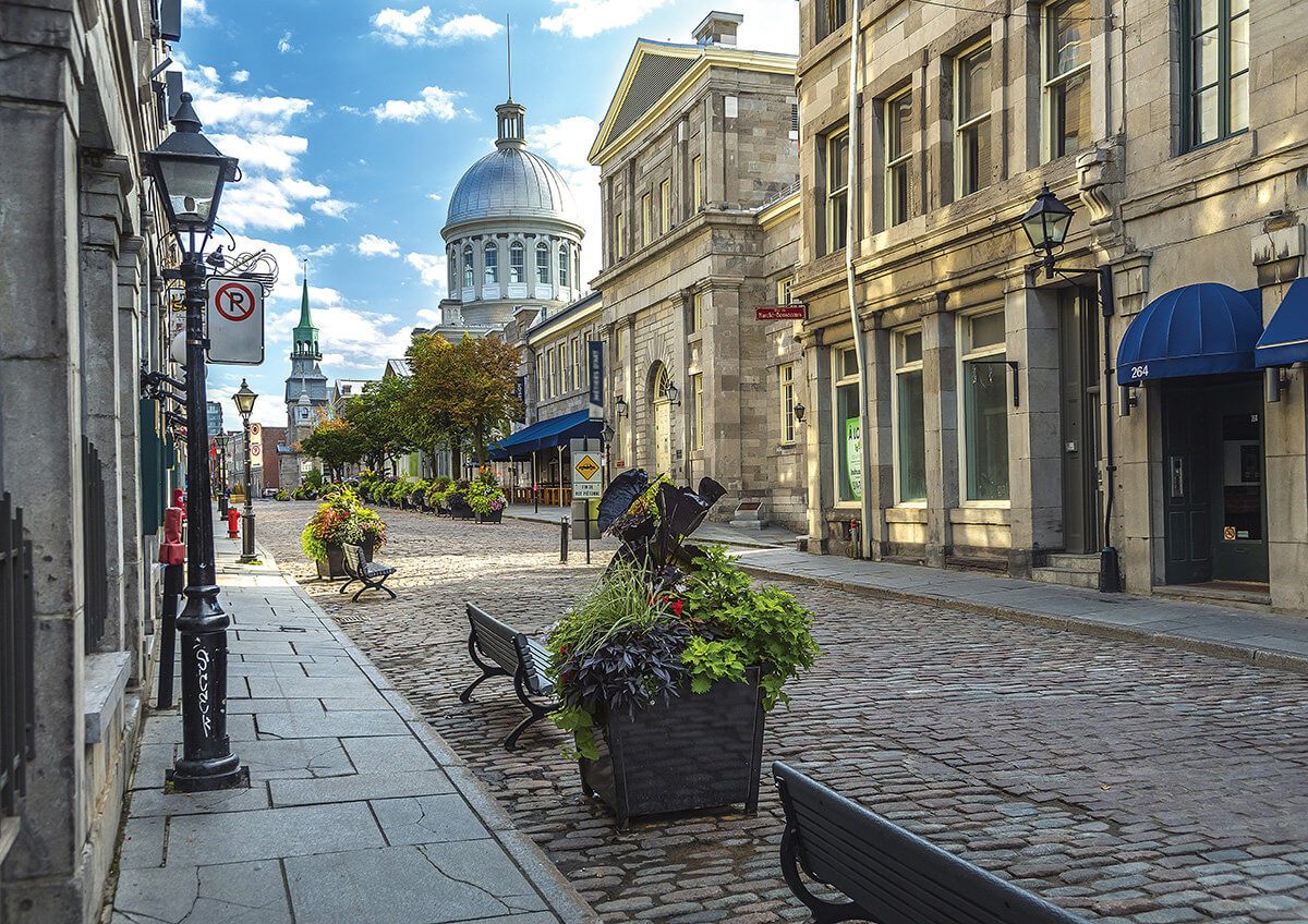
Vieux-Montréal. Basilique Notre-Dame de Montréal
https://sabai.tv/interesno-i-poznavatelno-10-vpechatlyayuschih-faktov-o-monreale/
Old Montreal is a historic quarter in the center of the second largest city in Canada, Montreal (province of Quebec). In 1964, the bulk of the oldest quarter was recognized as the country's national heritage. The borders of Old Montreal run mainly along the borders of old fortifications. The Museum of Archeology and History on the embankment of the port has an excellent observation deck.
In the south of the historic quarter is Place d'Armes: the main square of Montreal and the old city. The first skyscrapers of the city appeared exactly here: the first high-rise building New York Life Building was erected in 1888 and is made of red sandstone.
The most populous and lively place in the quarter is the Place Jacques Cartier. The famous French navigator who initiated the colonization of Canada. Above the square, the building of the town hall rushed into the sky, which is a striking example of French architecture. Next to the town hall is a majestic column — a monument to Admiral Nelson, which is a twin of the Nelson monument in London. The monument to the French officer Paul Chaomedie de Maisonneuve, the founder of Montreal (the city of Mary), is adjacent to the Notre Dame de Montreal Basilica.
The Old Town has a huge number of attractions that are very popular with tourists: a large public park, Champ de Mars, 7 museums, Notre Dame de Bonsecours chapel, Bonsecours market, preserved colonial mansions and much more. About 11 million tourists visit the heart of Montreal every year.
Location: Montreal, Quebec, Canada
Coordinates: 45°30′18″N, 73°33′18″W
https://wikiway.com/canada/monreal/notr-dam-de-monreal/photo/#gallery-26
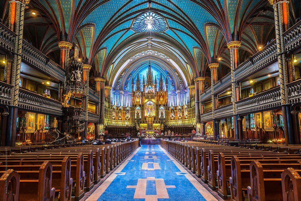
The Basilica of Notre Dame de Montreal (Notre Dame Cathedral) is a majestic Neo-Gothic cathedral located in Old Montreal on the main square, Place d'Armes. The cathedral was built of limestone in 1892 on the site of an old 17th century church, and has become the largest religious building in all of North America.
The height of the bell towers of the ancient basilica is 69 m. On Sundays, the melodic ringing of bells is heard throughout the district.
The interior is decorated with wall paintings, fine wood carvings, gilding, stained glass windows and wooden figures, so Notre Dame de Montreal is rightfully considered one of the most beautiful cathedrals in Canada and has the status of a national monument of the country.
Location: 275 Rue Notre-Dame Est, Montréal, Québec, Canada
Coordinates: 45°30′16″N, 73°33′22″W
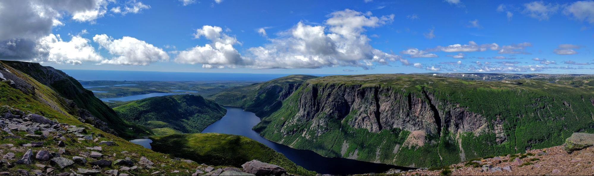
Gros Morne National Park, Newfoundland
https://imgur.com/gallery/BenoPr6
Gros Morne is a unique national park with great geological diversity located on the west coast of Newfoundland. Founded in 1973. Its total area is 1.8 thousand km².
Magnificent natural landscapes conquer the hearts of millions of tourists: glacial valleys, sea bays, high cliffs, waterfalls and fjords, high plateaus and lakes. The highest point is Mount Gros Morne is 806 m high, to the top of which there is a trail for those who are strong in body and spirit.
A feature of the reserve is the opportunity to see with your own eyes the result of continental drift: shifted tectonic plates and rocks of the Earth's mantle, which were exposed on the surface. The rich flora and fauna, forests of balsam fir, the opportunity to see whales (in the month of May), clean air, numerous arts festivals (for example, Music Trails, Tales and Tunes, theatrical Gros Morne, Woody Point Writers Festival) make visiting the park a popular tourist destination.
In 1987, the Gros Morne nature reserve was included in the UNESCO World Heritage List.
Location: Gros Morne National Park, Newfoundland and Labrador, Canada
Coordinates: 49°36′45″N, 57°45′10″W
Thousand Islands, Ontario
The Thousand Islands Tourist Region is located at the source of the St. Lawrence River (northeast of Lake Ontario) and is an entire archipelago of islands covering an area of approximately 2,000 km². The archipelago stretches 80 km along the Canadian-US border between Brockville and Kingston and has about 1,800 islands ranging in size from small tracts of land to 100 km². ⅔ of the islands belong to Canada. The depth of the river between the St. Lawrence Islands can reach 65 m.
Natural attraction is the national park “Thousand Islands” which includes only 20 of the most picturesque islands. Almost all of the islands are inhabited.
The largest and most populous island of the archipelago is Wolfe Island (29 km long, 9 km wide, population 1400).
Boldt Castle of the early XX century was built on the most famous island Heart Island. This place is associated with the romantic but sad love story of multimillionaire George Boldt and his wife. Today the castle houses a museum. The island itself is very beautiful and resembles a heart in its shape.
The famous castle of the world famous Singer Corporation is located on the Dark Island. The castle is open to tourists.
The Hub Island, with an area of only 306 m², is the smallest inhabited island in the world. Only one house of the Sizeland family was built on it.
Also one of the main attractions of these places is the International Bridge, built in 1938 and connecting the two countries.
The Thousand Islands Park is included in the list of unique natural phenomena of the biosphere and is included in the UNESCO list.
Location: Ontario, Mallory Town, Thousand Islands Parkway, 1121, Canada
Coordinates: 44°20′02″N, 75°59′41″W
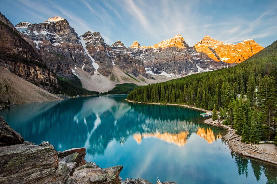
Canadian Rockies, Yukon
http://otomosem.com/2020/11/12/самые-красивые-озера-мира/moraine-lake/
The Canadian Rockies are the northern part of Pacific Cordillera in the Yukon Territory (western Canada). The Rocky Mountains stretch from north to south for 603 km and cover an area of 93.4 km². The highest point is Mount Robson (3954 m), the lowest point is the Liard River at an altitude of 305 m above sea level. Mostly the mountains are covered with forests. Magnificent mountains, glaciers, mountain valleys with turbulent rivers, beautiful lakes, hot springs, a variety of wildlife — all this creates a unique landscape.
Four National Parks: Yoho, Banff, Jasper and Kootenay are UNESCO World Heritage Sites (Canadian Rockies Parks):
- Banff. Canada's oldest National Park (1885). Located in the west of the province of Alberta, it is considered one of the most beautiful places on the planet (area 6.6 thousand km ²). Moraine glacial lake with turquoise water is widely recognized as a miracle of nature. The Trans-Canadian Highway runs through the entire park. Attendance: about 4 million people.
- Yoho. Formed in 1886 in British Columbia and is the smallest in area among the four national parks of the Rocky Mountains (it’s area is 1.3 km²). The park is characterized by a large difference in altitude, a large number of lakes. This park is home to the second highest waterfall in Canada — Takkako Falls (381.1 m). Coordinates: 51 ° 23′43 ″ N, 116 ° 21′12 ″ W
- Jasper is the largest nature reserve in the Rocky Mountains. Located in the province of Alberta on the eastern slopes of the Cordilleras (area 10.8 thousand km ²). Here is one of the world's oldest glaciers, Athabasca (over 10 thousand years old). It’s area is 200 km². Attendance: 2.1 million people. Coordinates: 52 ° 52′23 ″ N, 118 ° 04′56 ″ W
- Kootenay is a national park located in the southeast of British Columbia. Despite the small area of 1.4 thousand km ², it has the greatest variety of nature. Only in this park, in its southern part, there is a mountain basin that separates the Rocky Mountains from the Columbia mountains. The park also has hot springs in the Redwall Fault and Sinclair Canyon, and the cold springs of Paine Potts, which are rich in iron. Coordinates: 50 ° 52′59 ″ N, 116 ° 02′57 ″ WCoordinates: 50°52′59″N, 116°02′57″W
Location: Canada
Coordinates: 53°06′38″N, 119°09′21″W
Major airports in Canada
Canada has 10 major international airports and about 300 regional and local airports. The list of the National Airport System includes 26 airports, the passenger traffic of which is stable and at least 200 thousand people per year, or serving regular flights between the capitals of the provinces and territories of Canada.
https://svg-art.ru/?attachment_id=1293
|
|
|
|
|
|
|
|
|
|
|
|
|
|
|
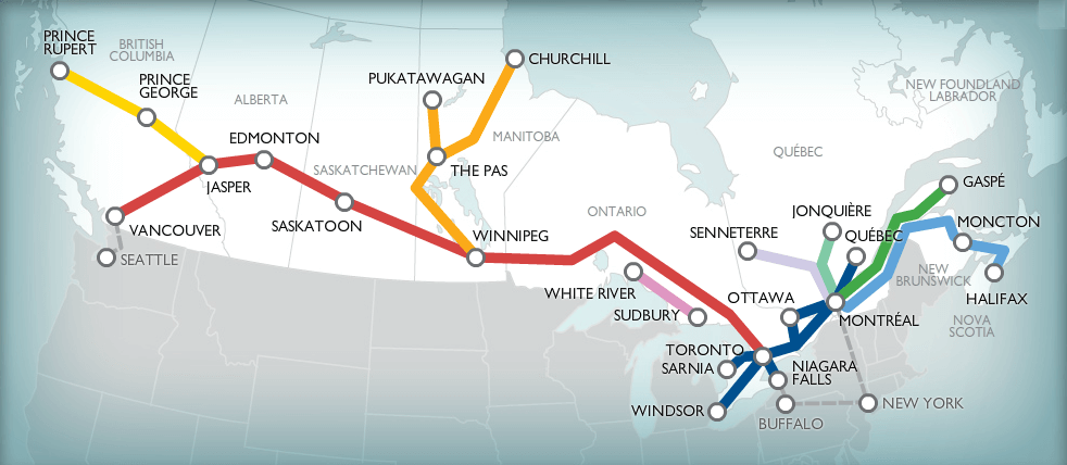
Major train stations in Canada
The transport system of Canada includes about 72 thousand railways in total.
The Canadian National Railway Company is the largest rail network in North America, with a total track length of 30,000 km. The history of the сompany dates back to 1919. Today it is the only transcontinental network in all of North America. Recently, passenger traffic has dropped drastically, and entire sections of railways are being closed in many provinces (for example, Vancouver Island no longer has rail links since 2019). Over the past 30 years, the length of the railway track has almost halved. About 400 trains of the national railways continue to carry passengers on important routes in the country.
Three main routes serving the direction from west to east (The Canadian, The Corridor, The Ocean), from which there are branches.
https://mishka.travel/blog/index/node/id/1610-poezda-i-jeleznaya-doroga-v-kanade/
|
|
|
|
|
|
|
|
|
|
|
|
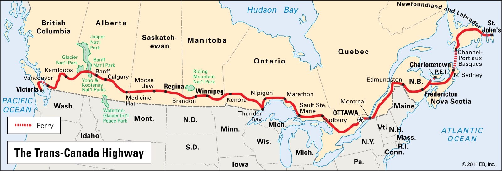
Highways of Canada
Today in Canada there are about 1.1 million km of roads (of which 415 thousand are paved, and 627 are unpaved). 17 thousand km are highways.
Road transport is the leader in passenger and freight transport in the country, generating huge income (35% of the GDP of the state's transport industry).
Officially, the National Highway System of Canada maintains three road classifications: Core, Feeder, and Northern / Remote.
Good quality roads are made with an ecology in mind and using modern technologies that increase the strength of the road surface. Repair of destroyed areas is carried out as soon as possible.
Major automotive road systems:
- Alaska Highway with a length of 2,237 km is unofficially considered an extension of the Pan American Highway. There are commemorative signs at the beginning and end of the route. Constant reconstruction is gradually reducing the length of the highway. The old kilometer pillars, which were based on historic miles, remain only from Lake Cloway to the border with Alaska.
- The Trans-Canadian Expressway is one of the world's longest national expressways. With its length of 7,821 km, it stretches across the country from ocean to ocean, connecting all 10 provinces of Canada.
- The northernmost road in North America is the 582 km long Trans taiga highway system, which runs through the province of Quebec.
http://www.campingcarcanada.fr/blogs/voyage-route-transcanadienne
Churchill
https://varlamov.ru/3339762.html?media
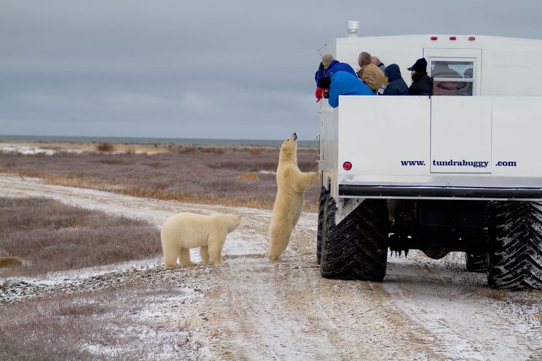
The small Canadian town of Churchill is world famous. It is located in the north of the sparsely populated province of Manitoba on the Hudson Bay coast, surrounded by wildlife. You can only get to Churchill by plane or train. Tourists from all over the world come to this region to see the harsh but beautiful arctic landscapes, admire the northern lights, see whales from the shores of the bay and meet polar bears.
The abundance of bears has become one of the engines for the development of ecotourism, but, on the other hand, a real misfortune for local residents who are trying to find a compromise with their large white neighbors.
There are only about 30 thousand polar bears left in the world, 10 thousand of which live on the ice of Hudson Bay. There are only two reasons for the bears to leave the ice for the mainland: the birth of offspring and the lack of food. One of the three maternity dens in the world, which are built by females, is located just outside the city of Churchill. During the summer months, when the ice in the bay melts, hunger drives animals in search of food closer to human settlements. There is a massive migration of animals, which is dangerous. Therefore, all houses and cars in the city are kept open so that there is an opportunity to hide.
Churchill has the only polar bear prison in the world, established in 1982 on the site of a former military base to keep animals that came to the city. For a month, personnel are trying to instill a rejection of the city to the animals so that they no longer return to it. For some time they are not fed, and then they are put to sleep and taken away by helicopter to a safe place far from the city.
Torn away from the world, the town with a surprisingly friendly population and difficult everyday life was named the world capital of polar bears and the pearl of Manitoba.
Location: Churchill, Manitoba, Canada
Coordinates: 58°46′05″N, 94°10′10″W