France map
Where is France. What is France
 https://www.zastavki.com/
French Republic (République française) is a Western European country with a highly developed economy, high culture and an advanced social sphere. It has the largest territory in Western Europe, and a high standard of living of the population. In addition to the mainland European lands, at the moment it has retained the part of its overseas territories (mainly Islands).
Actually historical France is washed by the Atlantic ocean and the Mediterranean sea and has got common borders with the following countries:
- Southwest by Andorra and Spain;
- South-Eastern with Italy and Monaco;
- Eastern with Switzerland;
- Northeast with Germany, Luxembourg, Belgium;
- Northern sea border with great Britain.
It is one of the world's leading tourist destinations, as France is a recognized world center of fashion, art and culture. It ranks fifth in the world in terms of the number of UNESCO world heritage sites and annually gets 70 - 90 millions of foreign tourists.

On the picture: two presidents of France: Emmanuel Macron and Charles de Gaulle
France is a semi-presidential Republic, a country with developed democratic institutions. One of the founding countries of the European Union since the 1950s, a permanent member of the UN Security Council and a member of NATO.
The total area of the country is 640 thousand km2. The country has a population of 67 million and an average density of 104 persons / km2. The official language is French, which is used by approximately 274 million people worldwide. GDP is on the 7th place in the world.
In France, there are hundreds of large and small rivers, of which 131 flow into the world ocean, and only 10 have a length of more than 300 km. That's Loire, Rhine, Rhone, Garonne, Seine, Meuse, Dordogne, Charente, Scheldt, Adour.
Mainland France is located in 1 time zone: it is 1 hour ahead of UTC. Car traffic is right-hand, and driving on studded car tires is allowed in winter, but there's a speed limit in 90 km/h for such cars.
Basic weather information. The Metropolitan Area is characterized by four climatic zones:
- Continental (center and East of the country)
- Atlantic (West)
- Mediterranean (South)
- Alpine
As a result, the climatic conditions are very diverse, but the climate of France as a whole is very favorable for life: a mild winter with almost no sub-zero temperatures (from 0 to 10 degrees the average temperature in January, except for the mountain Alpine zone, there are strong negative temperatures); warm summer without extreme heat (+14 to +29 average temperature in July).
Regions of France
Before 1790, France was divided into provinces instead of departments. This system of organizing regions was abolished after the French revolution and replaced by departments to effectively govern the country.
After the territorial reform of 2016, the country was divided into 18 regions (27 - before the reform), 5 of which are overseas territories. Regions, in turn, are divided into departments.
Regions are not allowed to engage in lawmaking and regulation, but at the same time they get the part of the taxes to their own budget from the central government. List of metropolis regions is:
Nouvelle-Aquitaine: It is Located in the South-West of the country, in addition to other French regions, it has borders with Spain, and is washed by the Atlantic ocean. It has an area of 84 thousand km2, and a population of 5.8 million people. The regional center is located in the city of Bordeaux.
Brittany (Bretagne): Region-a Peninsula in the North-West of the country with the administrative center in the city of Rennes, washed by the Atlantic ocean. The area is 27 thousand km2, and the population is 3.3 million people.
Bourgogne-Franche-Comté: It has Eastern borders with Switzerland, the regional center is located in the city of Dijon. The area of the region is 47 thousand km2, the population is 2.8 million people.
Normandie: It is a Region in the North-West of the country, with the regional center in the city of Rouen. The area of Normandy is 29.9 thousand km2, the population is 3.3 million people.
Ile-de-France: The Central region of France, with the administrative center in the capital of the state, the city of Paris. The area of the region is 12 th km2 with a population of 12.1 million people (the first place among the French regions with population).
Corsica (Corse): An island in the Mediterranean sea, the fourth largest. One of the regions of France, with the administrative center in the city of Ajaccio, an area of 8.6 thousand km2 and a population of 314 thousand people.
Occitanie: The region is in the South of the country, bordered by the Mediterranean sea and bordered by Andorra and Spain. The administrative center in the city of Toulouse, an area of 72.7 thousand km2, a population of 5.6 million people.
Grand-Est: Eastern region with the center in the city of Strasbourg, an area of 57 thousand km2, and a population of 5.5 million people. It has borders with 4 European countries-Germany, Belgium, Luxembourg and Switzerland.
Hauts-de-France: A region in the North-East of the country bordering Belgium. It is washed by the North sea and the Pas-de-Calais Strait, has an area of 31.8 th km2, a population of 5.9 million people and an administrative center in the city of Lille.
Auvergne-rhône‐Alpes: Is Located in the East of France, has a common border with Switzerland and Italy. The administrative center is located in the city of Lyon, the area of the region is 69 thousand km2, the population is 7.7 million people.
Lands of the Loire (Pays-de-la-Loire): The Western region of France, centered in the city of Nantes, is washed by the Bay of Biscay. It has an area of 32 thousand km2, and a population of 3.5 million people.
Provence-Alpes-Cote d'azur (Provence-Alpes-Côte d'azur): The extreme South-Eastern French region, with the center in the city of Marseille, an area of 31.4 thousand km2, and a population of 5 million people. Bordered by the Principality of Monaco and Italy, it is washed by the Mediterranean sea.
Centre-Val de Loire: The region in the North of the center of the country, the administrative city is Orleans. The area of the region is 39.1 thousand km2, the population is 2.5 million people.
Overseas regions are:
Guadeloupe: It is a Region and overseas Department of France in the Caribbean sea, consisting of six Islands with a total area of 1.6 thousand km2 and a population of 382 thousand people. The administrative center is the city of Bas-Ter.
Guiana (Guyane): The largest overseas French region and Department with an area of 83.5 km2, is located in the North-East of South America, washed by the Atlantic ocean, bordered by Suriname and Brazil. Due to the close equator, France has built a space launch complex (cosmodrome) here. The administrative center is the city of Cayenne, the region is inhabited by 237 th people.
Martinique: It is a Region and overseas Department of France, an island in the Caribbean sea, in the archipelago of the Lesser Antilles with an area of 1.1 thousand km2 and a population of 392 thousand people. Its administrative center is the city of Fort-de-France.
Réunion: An island in the Indian ocean, located 700 km East of Madagascar. Overseas region of France with the administrative center in the city of Saint-Denis, an area of 2.5 th km2 and a population of 828 th people.
Mayotte: An overseas region and overseas Department of France located in the Mozambique channel and consists of several Islands, with the administrative center in the town of Mamoudzou. The area of the region is 376 km2, the population is 246 thousand people.
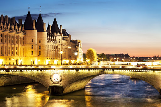
The most interesting sights of France
Palace of Versailles (Château de Versailles)
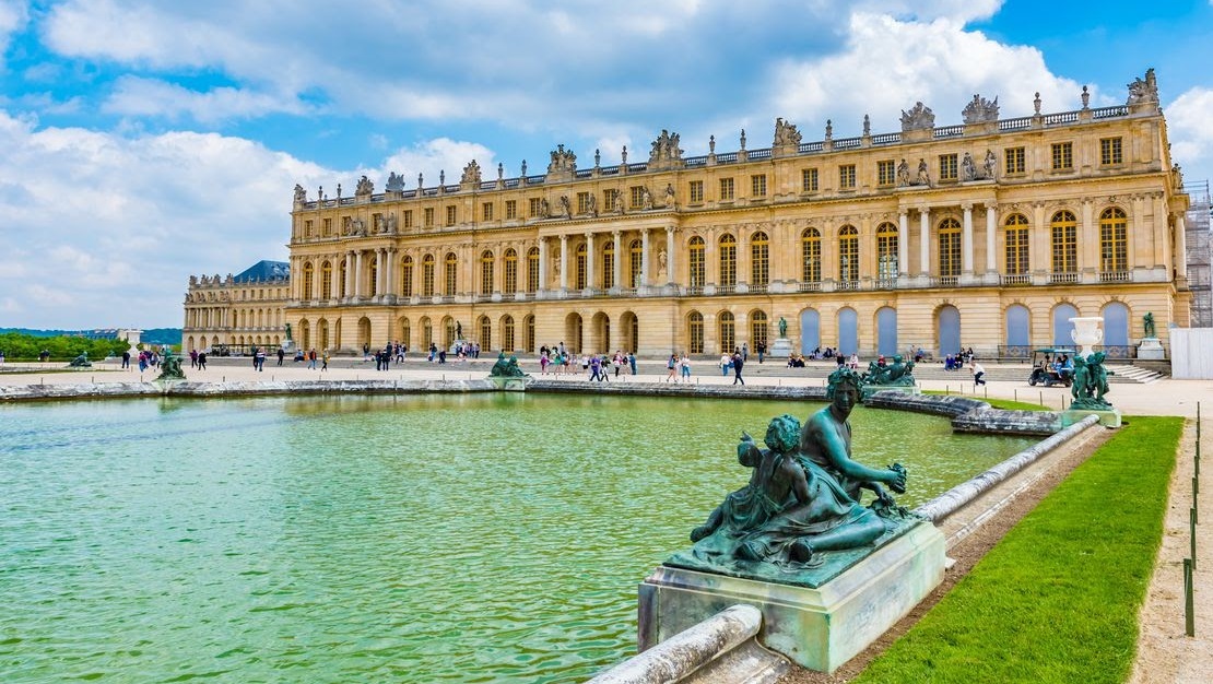 https://archive.curbed.com/
Unsurpassed Palace and Park ensemble, which has received worldwide fame, the main residence of the French kings. Becoming a turning point in the art of gardening, caused imitations among European rulers. Many significant historical events are somehow connected with this place; the Palace of Versailles is included in the UNESCO world cultural heritage list. The Palace of Versailles is associated with becoming of France as a leading European nation-state, governed from a single decision-making center (the royal court). "The state is me" - the formula of Louis XIV, meaning that he himself is the sovereign who manages the entire state French bureaucracy. Location: Place d'Armes, 78000 Versailles, France / 48°48′16″N 2°07′23″E (48.805041536112185, 2.120312482960958).
Castles of the Loire (Châteaux de la Loire)
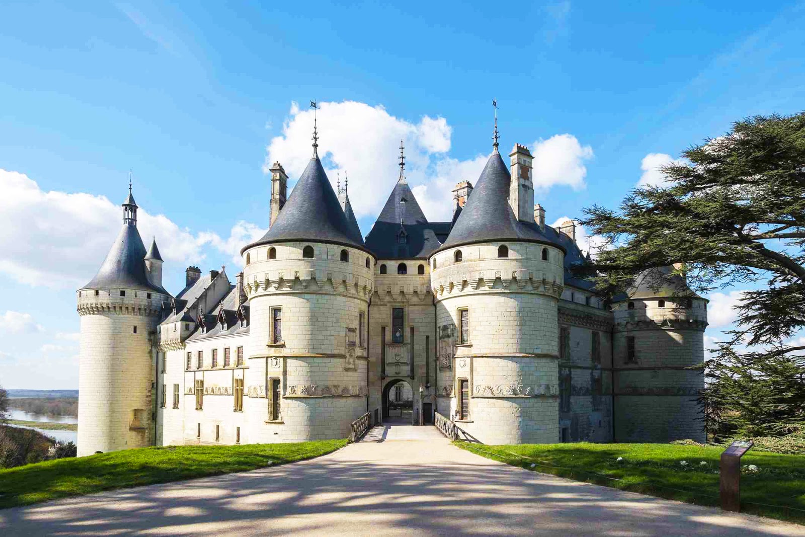 https://www.tripsavvy.com/
Thanks to its many beautiful architectural monuments, the Loire valley has been listed as a UNESCO world heritage site. This object includes castles and other 77 buildings that belonged to the aristocrats. Jusse Castle (on the picture) was built in the 15th century at the junction of two architectural styles: the outgoing Middle Ages and new coming Renaissance. A legend says that Charles Perrault, fascinated by this castle, described it in the fairy tale "Sleeping Beauty". And Chateaubriand wrote his "Sepulchral Notes" also here. The castle looks fabulous not only from the outside, but also the inside. From ancient times, there are many tapestries of the 18th century, hung on the walls of the gallery connecting the east and west wings. The walls of the rooms are decorated with real silks of that time. And the wine store is conserving many bottles filled several centuries ago. Location: Loire river Valley and its tributaries. Office: 8 Rue de Balzac, 37000 Tours, France.
Saint Michael's Mount Abbey (Mont Saint-Michel)
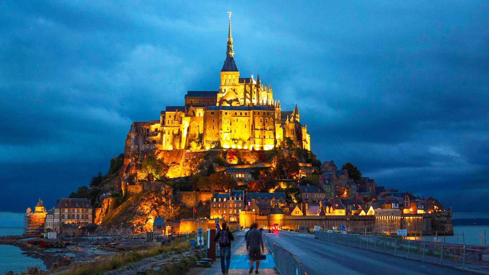 https://www.pinterest.ru/
Granite island-fortress in the North-West of France, founded in 709 AD. Popular with tourists: up to 3.5 million people visit mount St. Michael Abbey every year. A unique monument of nature and architecture is a small city built on a rock, which is located in a small bay. During the tides, this Abbey is cut off from the mainland. The ancient architecture has been preserved on the island, despite the numerous sieges that has occured over the 1500 years of its existence. Chapels and fortress walls are of great interest not only from the historical point of view, but also from the engineering point of view. Location: Le Mont Saint-Michel 50170 France / Coordinates: 48°38′08″N 1°30′38″E (48.6355702061022, -1.511207991070324).
The caves of Lascaux (Grotte de Lascaux)
 https://www.artranked.com/topic/Lascaux
One of the most important monuments in the world of paleotic art. The caves contain a large number of high-quality rock paintings made about 19 th years ago. They were found in 1940 and now discover us the new era in our knowledge of both prehistoric art and human mental history. They say: "Sistine chapel" of primitive painting. Now we know more about the formation of man as an independent species, separated from nature. Location: 24290 Montignac France / Coordinates: 45.054676039549726, 1.1678655431810974.
Mount Blanc (Mont Blanc)
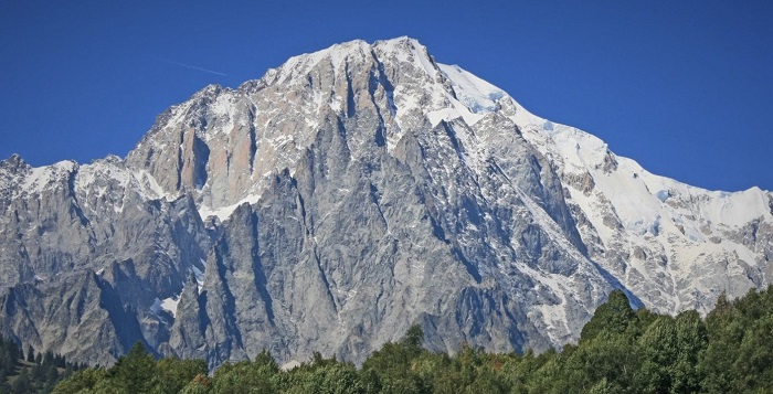 https://peakfinder.ru/peak/view/105_monblan
Mount Blanc (white mountain) – the highest point of the Alps and Western Europe is rising to 4,808 m. Blanc is located on the border of Italy and France. The mountain is attractive for tourists for outdoor activities like climbing, hiking, trail running and skiing/snowboarding in winter. The most interesting climbing route to the summit of Mount Blanc is Goûter Route: it needs typically two days. Living near thermal springs is also very popular with tourists. Up to 30 thousand people come here in the season. Under the mountain is a tunnel connecting France with Italy. Coordinates: 45.833309197295286, 6.865131951575816.
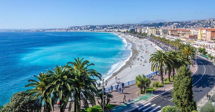
French Riviera (Côte d'Azur)
 https://provence-alpes-cotedazur.com/
The South-Eastern coast of the Mediterranean at the foot of the Maritime Alps, with a length of about 300 km. It is considered one of the best places in the world for recreation due to the favorable climate: warm winter (average temperature in January +10 °C and not hot summer (average temperature in July +24-26 °C); the bathing season lasts from the end of may to the end of September. Location: From Toulon: 43.102099063404, 5.943827172922021. Up to the boundary with Italy: 43.78459202094239, 7.529291655616796.
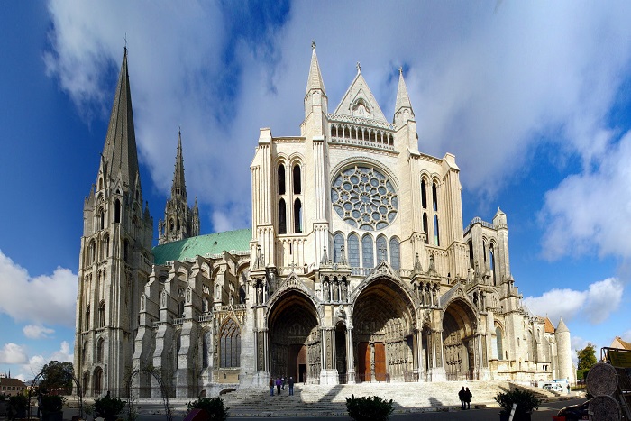
Chartres Cathedral (Cathédrale Notre-Dame de Chartres)
 http://visitefrance.ru/
One of the main Catholic Cathedral (built in 1194 - 1260) in France is located 90 km South-West of Paris. The French masterpiece of Gothic architecture with preserved medieval stained glass windows. The greatest fame was brought to him by the most valuable relic – the shroud of the Virgin Mary. According to legend, the Virgin was dressed in it at the time of the birth of Jesus Christ. This legendary shroud was donated in 876 by the French King Charles II to the city of Chartres. And a large temple was built to store it, which has not been preserved (destroyed by fire in 1020). Built in its place, the Gothic Chartres Cathedral has survived to our days without significant alterations and reconstructions. Location: 16 Cloître Notre Dame, 28000 Chartres, France / Coordinates: 48°26′50″N 1°29′16″E (48.447923558911384, 1.4878692845550274).
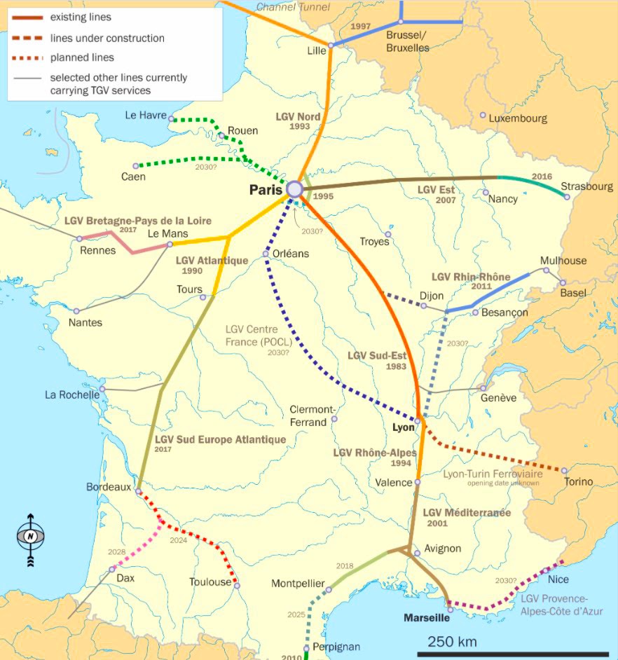
France high speed train map
France has the second largest railway network in Europe, with a length of 30 th kilometers, with transportation indicators of 1.7 billion passengers annually. For fast passenger transport at speeds up to 320 km/h, the national network of high-speed electric trains TGV (Train à Grande Vitesse) is used, which runs in cities in the South, North-East and West of the country. The network is connected to similar networks of neighboring countries. The map of TGV is folowwing:
 https://en.wikipedia.org/wiki/TGV
5 largest train stations in France
|
Toulon train station It is located near the border with Italy. It works around the clock. High-speed TGV trains, intercity and regional. |
Boulevard de Tessé 83000 Toulon. Coordinates: 43°7′43″N 5°55′47″E |
|
Gare de Marseille Saint Charles One of the oldest railway stations in the country (opened on 8.01.1848), passenger traffic is up to 16 M people a year. |
Square Narvik, 13232 Marseille, Cedex 1. Coordinates: 43° 18′ 13″ N, 5° 22′ 47″ E |
|
Gare du Nord de Paris The busiest gare in Europe. Passenger traffic is 180 million people every year. |
18 Rue de Dunkerque, 75010 Paris. Coordinates: 48° 52′ 54″ N, 2° 21′ 22″ E |
|
Gare de l'Est de Paris The oldest and largest railway station in the city. It works mainly in the Eastern directions of France |
Place du 11 novembre 1918, 75010 Paris. Coordinates: 48° 52′ 39″ N, 2° 21′ 33″ E |
|
Paris - Gare-de-Lyon One of the largest train stations operating in the southern direction of France, as well as serving international traffic (110 millions de passagers in 2018). Multi-level transport hub including RER |
Place Louis-Armand, 75571 Paris. Coordinates: 48° 50′ 41″N , 2° 22′ 25″ E |
Highways in France
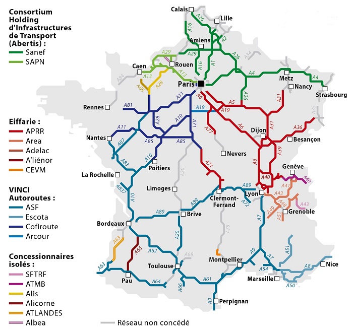
Map of toll roads in France (http://frenchtrip.ru/)
The total length of roads in France is 1.05 million km, of which 11 th kilometers of highways, where the permitted speed is 130 km / h for passenger cars, and 90 for trucks and public transport. A significant part of the roads in France are paid, they are built, managed and maintained by private companies. This decision was made in the 50s of the last century, for the rapid development of the road network. Highways are designated by the letter "A", and the serial number. Many motorways are included in the European rapid transit system and have an additional designation with the letter " E " followed by a license plate.
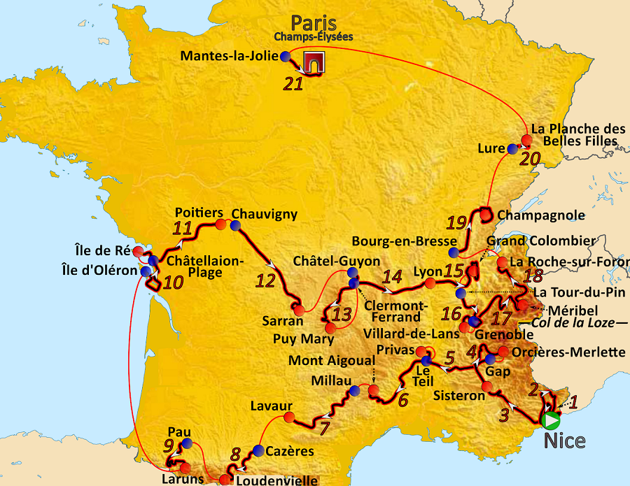
Editors' choice: Tour de France race with map
It is the most prestigious multi-day Cycling race in the world, held for more than 100 years in France, annually. The unofficial name of the event is "Big loop". Runs for three weeks in July, the track and length changes every year, so the final length of the race is different every year, usually between 3000 and 4000 kilometers. The race was only canceled during world war I and world war II; and in 2020, due to the covid-19 epidemic, it was postponed to August-September: there were 22 teams and 176 ridres started the race in Nice.
 https://ru.wikipedia.org/