India map
https://www.putivodi.ru/articles/india/stolitsa-indii/
India (Republic of India) is the largest and most populous country in South Asia: about 1.4 billion people live in an area of more than 3.2 million km² (population density is 411.5 people / km²). In terms of population, the state is on the second line of the world ranking. The capital is New Delhi. The country has two official languages: Hindi and English.
India is located on the Indian subcontinent and occupies most of it. The origins of the ancient Indian civilization (the third in time of appearance) are located here. India has always occupied an important place in the world, being the center of trade routes and the cradle of world religions (Buddhism, Hinduism). And today this potential superpower has not lost its importance and is rapidly developing, although still a large part of the population lives below the poverty line. GDP is about 2.6 trillion dollars, per capita is 1877 dollars.
The highest mountain system in the world is the Himalayas and the Thar Desert in the north-west of India have a great influence on the formation of the climate in the country. 4 main types of climate prevail:
- dry tropical,
- humid tropical
- subtropical monsoon,
- alpine.
There are three distinct weather seasons:
- hot and dry season in spring (average temperatures in May +28 ...+35);
- hot wet season (monsoons bring more than 80% of annual precipitation). All summer, September and October;
- a cool and dry season dominated by the northeastern trade wind is November and winter months (air temperatures from +15 to +27, depending on the region).
Time zone: UTC +5: 30.
India is one of the countries with the richest diversity of flora and fauna (33% of plants; 12.6% of mammals; 4.5% of birds; 55.8% of amphibians; 45.8% of reptiles are endemic). More than 500 national parks (including 13 biosphere parks) are designed to preserve the unique natural wealth of India.
The land of contrasts is visited by millions of tourists every year: in 2019, more than 10 million people arrived to plunge into the unique atmosphere of the country.
India is a federal state, a sovereign socialist secular liberal democratic republic with a bicameral parliament.
Coordinates: 21°07′32″N, 78°18′38″E
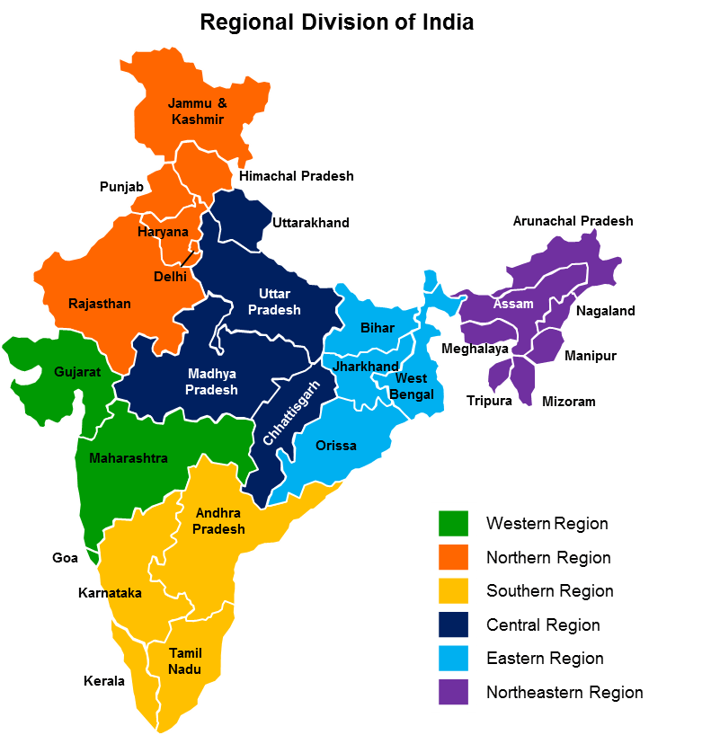
Regions of the country
https://www.cleanpng.com/png-northeast-india-china-sino-indian-war-sino-indian-3277780/
The country is divided into 28 states and 8 union territories, including the national capital district of Delhi.
Currently in India there are:
- states (have their own legislative and executive bodies; head is the governor): Andhra Pradesh, Arunachal Pradesh, Assam, Bihar, Goa, Gujarat, Jharkhand, West Bengal, Karnataka, Kerala, Madhya Pradesh, Manipur, Maharashtra, Meghalaya, Mizoram , Nagaland, Orissa, Punjab, Rajasthan, Sikkim, Tamil Nadu, Telangana, Tripura, Uttarakhand, Uttar Pradesh, Haryana, Himachal Pradesh, Chhattisgarh.
- Uttar Pradesh. Located in the north of the country (area 240.9 thousand km ²). Leading in the list of the 10 most densely populated administrative units in the world (population about 200 million people). There are 18 regions in the state.
- Rajasthan. The largest in India (area 342.2 thousand km², population 66.6 thousand people). 4 national parks: Desert (area 3162 km2), Ranthambore (area 392 km2), Sariska (area 866 km2), Keoladeo (area 29 km2). The basis of the economy is agriculture and cattle breeding. It is the leader in the production of wool, milk and one of the largest producers of oilseeds).
- Maharashtra. It is the third largest and second most populous state located in the central part of the country (an area of more than 307 thousand km², a population of 112.3 million people). The capital is the city of Mumbai. Divided into 36 districts. It occupies a leading position in industry (46% of GDP, 15% of the total national product in the country, brings about 40% of all government revenues). The largest center of the film industry, a software exporter, the country's main financial region and a leader in power generation.
- Madhya Pradesh. The second largest state (area 308 km², population 72.5 million). It is located in the center of the country and is divided into 50 districts. On its territory there are 9 national parks and 25 nature reserves. Basis of the economy: cotton industry, mechanical engineering, metalworking.
- Goa. Well known to the whole world, the smallest state in India is located in the south-west of the country on the coast of the Arabian Sea (area 3702 km², population over 3.1 million people). Administratively divided into North and South Goa. The main resort in the country and one of the richest states. The economy is based on tourism.
- union territories (headed by representatives of the government of the state: commissioners or administrators): Andaman and Nicobar Islands, Dadra and Nagar-Haveli and Daman and Diu, Jammu and Kashmir, Ladakh, Lakshadweep, Pondicherry, Chandigarh and Delhi (national capital district).
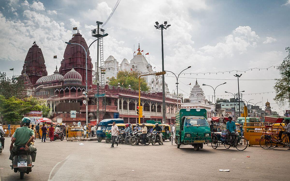
- The national capital district of Delhi. The most densely populated area (population about 16.6 million inhabitants, an area of only 1.48 km²). The territory is divided into three city corporations: Delhi (1397.3 km²), New Delhi Municipal Committee (42.7 km²) and the Military Council of Delhi (43 km²) and 9 districts. Delhi is the most economically developed city in the country and the largest business center in North India. The economy is based on information technology, financial services, tourism, media, manufacturing industry.
- Jammu and Kashmir. Second most populous union territory located in the north of the country (population about 12.3 million people, area 42.2 thousand km²). This is the only region where the majority of the population is Muslim (97%). The economy is based on ecotourism.
The most interesting sights of India
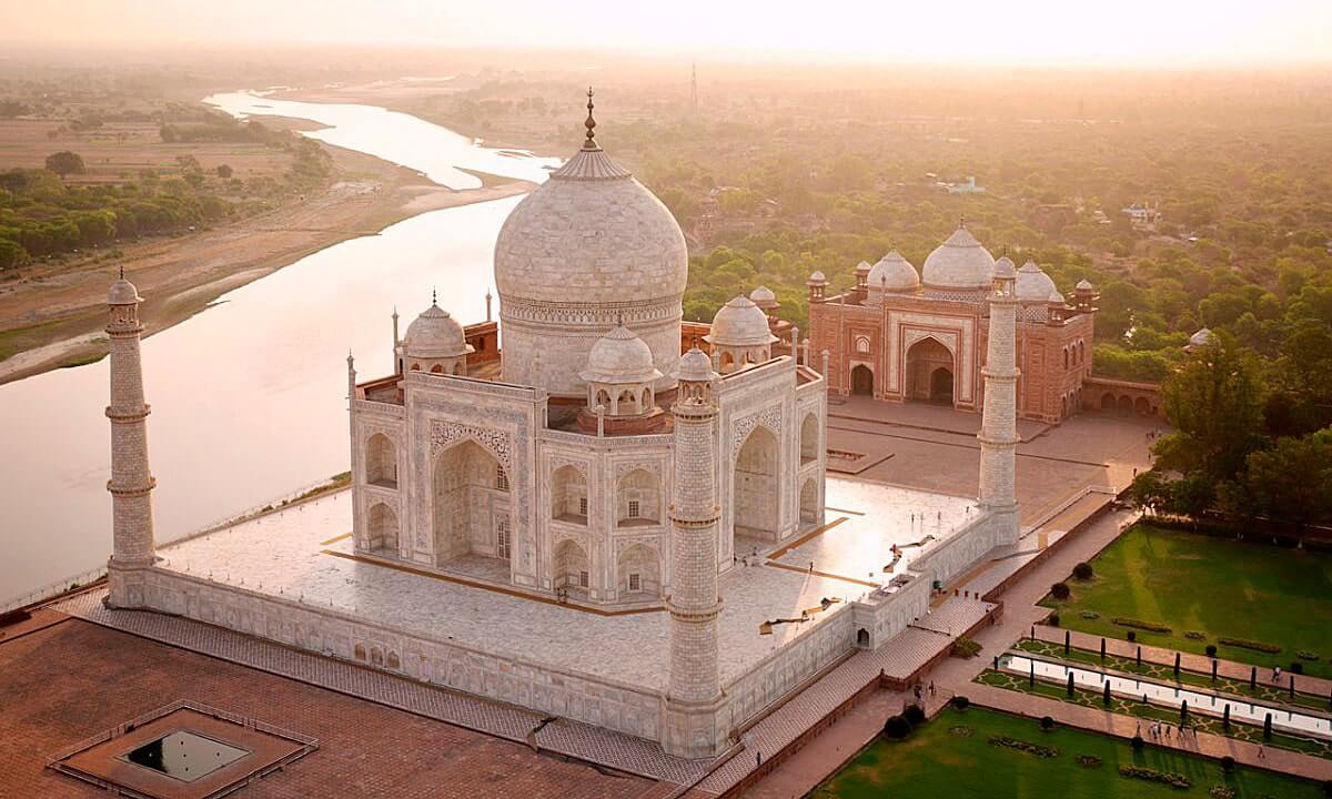
Taj Mahal
https://interesnyefakty.org/tadzh-mahal/
The Taj Mahal (Crown of Palaces) is one of the finest examples of Mughal architecture mixed with Indian, Arabic and Persian styles. This magnificent mosque is located in the north of the country: in the city of Agra on the banks of the Jamuna River (Uttar Pradesh state). The pearl of India was built by order of Shahab-ud-din Muhammad Khurram in memory of his deceased wife Mumtaz Mahal. More than 22 thousand craftsmen took part in the construction.
The architectural complex has a rectangular shape (about 600 m x 300 m) and is surrounded by red sandstone walls. Wall thickness reaches 9 m. The mausoleum is built of polished translucent marble and is a five-domed structure with a height of 73 m on a platform. In the corners there are 4 minarets 41 m high, inside there are two tombs (of the shah and his wife). The white walls, adorned with intricate marble carvings and inlaid gems, have the unique ability to change color: they turn pink at sunrise, and silver in the moonlight. There is a beautiful park with marble paths, fountains and a swimming pool near the mosque (the area of the garden and park zone is 300 km²).
Since 1983, this architectural masterpiece celebrating love has become a UNESCO World Heritage Site, which is visited by about 5 million tourists annually.
Location: State Highway 62, Tajganj, Uttar Pradesh, Agra, India.
Coordinates: 21°07′32″N, 78°02′31″E
Dudhsagar waterfall
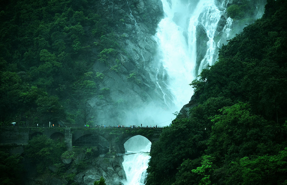
https://karmagroup.com/blog/monsoon-in-india-things-to-see/
Dudhsagar Falls ("sea of milk") is one of the highest waterfalls in India (5th place). Located on the Mandovi River in the Bhagwan Mahavir Nature Reserve and Mollem National Park (60 km from the state capital of Goa, Panaji). The height of this four-tiered waterfall is 310 m, and the width is 30 m, the total length is more than 600 m. At the waterfall there is an ancient bridge, built in colonial India.
The waterfall looks especially impressive during the monsoon season, but it is difficult to get to it at this time. The best time to visit is from November to February.
No less interesting are the surroundings of the waterfall, which are dense deciduous forests with rich flora and fauna. Tourists cannot avoid meeting wild monkeys
Location: Bhagwan Mahavir Wildlife Sanctuary 403410, India.
Coordinates: 15°18′44″N, 74°18′51″E
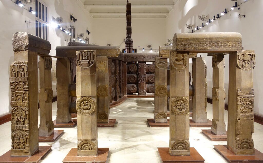
Indian museum
https://paintingbazaar.in/15-best-art-galleries-in-india/
The Indian Museum is the oldest museum in India and is also one of the oldest galleries in the world. Founded in 1814 by Danish biologist Nathaniel Wallich in the city of Serampore near Kolkata. Built in 1875 in the Victorian style, the museum's own 3-storey building has become an outstanding architectural monument. Today the museum is also a center for research into the traditions, culture and history of India.
The museum has 35 galleries with over 100 thousand exhibits.
14 halls present them:
- Gallery of stones and minerals. Contains a unique collection with a large variety of minerals, gems and fossils.
- The anthropological. Presents objects of the life of tribes and samples of creativity of masters of India.
- Numismatics gallery. Contains a large collection of coins.
- Zoological collections of exhibits from scientific expeditions in India.
- Egyptian Gallery. The main attraction is a mummy (4 thousand years old).
- The Art Gallery. Exhibits samples of textiles collected in different regions of the country (printed fabrics, embroidered shawls, woven rugs, brocade) and historical items of folk art made of wood and metal.
- Gallery of masks.
- Nahar Gallery of Oriental Art with Mongolian paintings and Persian miniatures of the 17th century.
Of particular interest to visitors are the skeletons of prehistoric animals, the ashes of the Buddha, the sparkling pillar of Ashoka, artifacts of the Harappan civilization and the emerald cube of Shah Jahan.
Location: 27, Jawaharlal Nehru Rd, Fire Brigade Head Quarter, New Market Area, Dharmatala, Taltala, Kolkata, West Bengal 700016, India.
Coordinates: 22°33′29″N, 88°21′03″E
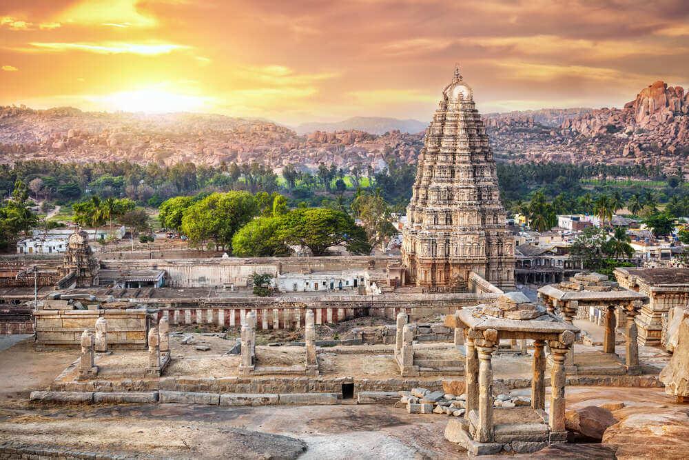
Hampi Monuments and Vijayanagara Ruins
https://travellizy.com/ru/journal/post/south_india_places
Hampi is a settlement located on the banks of the Tungabhadra River in the north of Karnataka (southwest India). The small village is located in the center of the ruins of the former capital of the Vijayanagar Empire, one of the richest cities in the world, which existed more than 400 years ago.
Hampi is a cult place and an important center of Hinduism, which has preserved a large number of architectural monuments, scattered over a large area around the village. The 120-meter high Matanga hill is one of the shrines of India, which offers a stunning view: temples, ruins of markets and various baths, and much more. The ruins occupy an area of 26 km².
In the vicinity of the village there are numerous huge boulders that were used by ancient sculptors to create statues of deities. And now this unique landscape is a mecca for rock climbers, fans of bouldering.
Until now, about 300 ancient temples have survived in Hampi:
- Virupaksha Temple (active). The main, largest and most ancient temple complex in Hampi, dedicated to the god Shiva.
- The Vittala Temple (active). The most beautiful architectural structure of the Vijayanagar ruins with unique singing columns. Dedicated to the god Vishnu.
- Lotus Temple. Made in a mixed style, combining the architectural lines of the Hindu and Islamic styles. The two-storey building with arched windows, built for the queen, looks like a lotus flower and adorns the so-called women's quarter.
- Khazar Rama Temple. A temple dedicated to the deity Rama, decorated with panels with graceful carvings and basilicas.
- Narasimha Temple (active). A temple dedicated to one of the incarnations of Vishnu, famous for the largest statue of Narasimha (lion-man). The height of the attraction is 7 m.
- Badawaling Temple. The temple houses the largest Shiva Lingam (3 meters high) made of black stone. Even in a drought, there is always water in the temple.
- Little Ganesha. Temple attracts tourists with an impressive 1.5 meter high statue of Ganesha.
- other.
Ruins of Vijayanagara (Hampi Monuments) has been a UNESCO World Heritage Site since 1986.
Location: Hampi, Karnataka 583239, India.
Coordinates: 15°20′N, 76°28′E
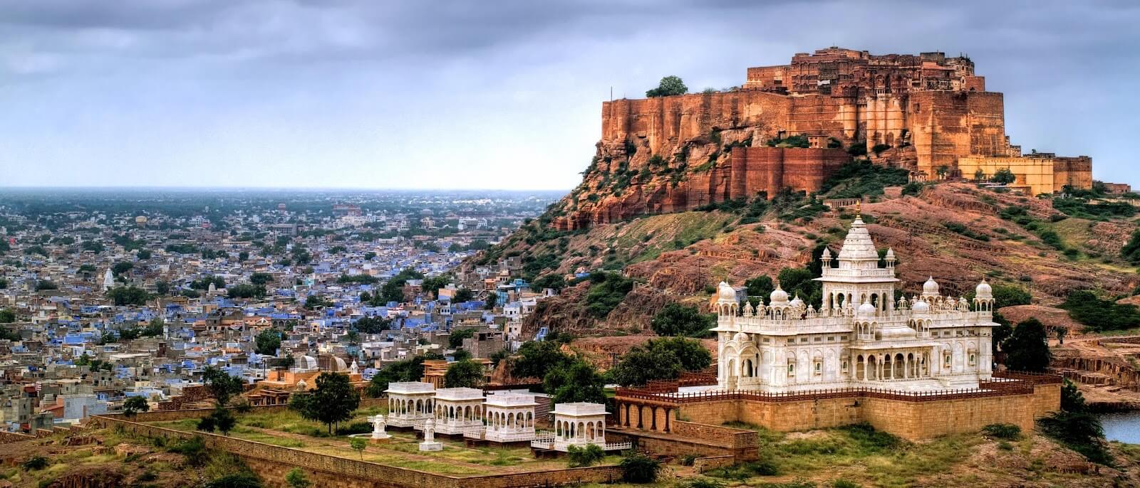
Jodhpur City and Mehrangarh Fortress, Rajasthan State
http://welcomeincredibleindia.blogspot.com/2017/03/top-most-forts-in-rajasthan.html
The amazing city of Jodhpur was founded in 1459 and is located at the foot of the Marwara Cliffs on the outskirts of the Thar Desert, in the northwestern part of the state of Rajasthan. This city is also called the City of the Sun for the always good weather or Blue City for the blue roofs of houses, as a sign of the place of residence of the brahmanas. Today the city is home to over 1.1 million people.
On Chittar Hill, there is the world's largest private residence: the Umaid Bhawan Palace. The area of the palace complex is 10.5 hectares (1.4 hectares of buildings, 6.1 hectares of gardens).
On the top of a 125-meter hill on the rocks of Marwara, the founder of the city of Jodhpur erected the Mehrangarh fort, Sun fortress. The impregnable fortress with an area of 0.2 km² is one of the largest defensive structures in India (the height of the walls is from 6 to 36 m, the width is 21 m). Behind the fortress walls, tourists discover the splendor of the palace complex, which includes:
- Moti Mahal (Mirror Palace),
- Sheesh Mahal (Pearl Palace),
- Phul Mahal (Flower Palace),
- Sileh Khan's palace,
- Daulat Khan's palace,
- the best museum in the state,
- and the armory.
To get inside the fort, you need to go through 7 gates.
Location:The Jodhpur Fort, Sodagaran Mohalla, Jodhpur, Rajasthan 342006, India.
Coordinates: 26°17′53″N, 73°01′08″E
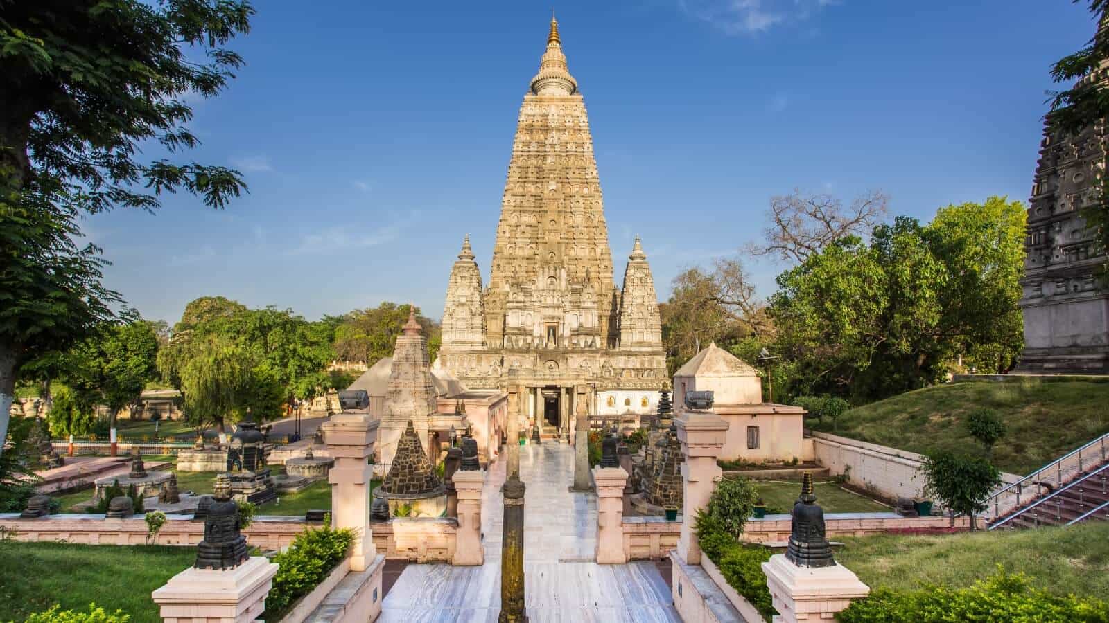
Mahabodhi Temple, Bodh Gaya
https://www.nirmalatravels.com/kashi-gaya-rajgir-14-days/
The Mahabodhi Temple (Temple of the Great Awakening) is located in the small town of Bodh Gaya, Bihar state. The founder of the temple is considered to be King Ashoka, the ruler of the Mauryan empire. And the date of foundation is 260 BC. The temple is built on the site where Gautama Siddhartha attained his enlightenment and became a Buddha. The Bodhi tree in Uruwella Grove is sacred to Buddhists and is also part of the temple complex. The sacred relic is the banyan tree (ficus, Indian fig tree).
This unique architectural monument is considered one of the oldest brick buildings in eastern India. The temple is built in the form of a multi-tiered pyramid with four entrances. Its height is about 50 m.
Today the town of Bodh Gaya is one of the main places of Buddhist pilgrimage. More than 400 thousand people visit the city annually.
Since 2002, the Mahabodhi Temple has been included in the UNESCO World Heritage List.
Location: Bihar 824231, Bodh Gaya, India.
Coordinates: 24°41′345″N, 84°59′29″E
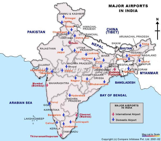
Major airports in India
Modern India is one of the countries where the aviation market is developing very rapidly. Airports Authority of India (AAI) operates 137 airports (23 international, 10 customs, 81 domestic, 23 civilian enclaves).
In 1972, the International Airports Authority of India (AAI) was formed and in 1986 the National Airports Authority of India (NAAI) was formed to manage domestic airports.
https://cosmoschronicle.com/india-to-build-100-new-airports-before-2030/
|
|
|
|
|
|
|
|
|
|
|
|
|
|
|
|
|
|
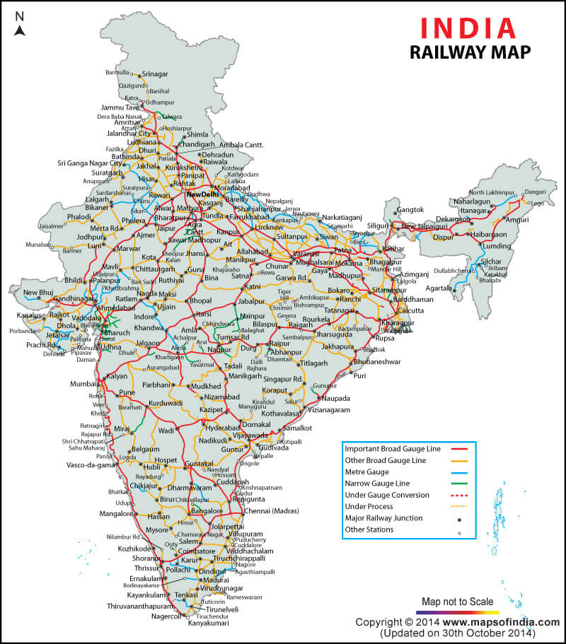
Major train stations in India
The first railway in the country appeared in 1853. The entire railway system has been nationalized, and virtually the sole owner is the state-owned Indian Railways.
Rail transport is the most popular and demanded mode of transport in India: cheaper than air and more comfortable than bus transport.
In terms of the length of the railway track, the Indian railway ranks 4th in the world (63.1 km). The annual passenger turnover is 6 billion people, and cargo transportation is 350 million tons per year.
The downside of widespread and widespread use of rail transport is the leadership in the number of rail accidents.
http://www.projectmapping.co.uk/Europe%20World/indiatrainrailma.html
|
|
|
|
|
|
|
|
|
|
|
|
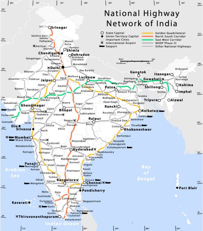
Highways of India
The total length of roads in India in 2017 was 5.6 million km (200 km of expressways). It is the second largest in the world after the United States. India's National Highways network covers all major cities as well as state capitals. Passenger traffic using road transport accounts for 80% of all traffic in the country, freight for about 65%. Federal roads, which occupy 2% of the entire road network, provide 40% of traffic.
The roads are of good enough quality for comfortable movement, mostly three- and four-lane. Left-hand movement. There are many toll roads.
Part of the National Highway Development Project in India is the Golden Quadrangle project (5846 km between Chennai, Calcutta, Delhi and Mumbai).
TOP best roads in India:
- Ahmedabad-Vadodara is the best quality road in the country (93.1 km). The busiest highway connecting the cities of Ahmedabad and Vadodara.
- Delhi-Gurgaon (27.7 km), the most important expressway connecting the capital and Millennium city of Gurgaon.
- Mumbai-Pune (94.5 km) is the first six-lane high-speed highway in India, which connects the financial capital of India, Mumbai, with the cultural center of the state of Maharashtra, the city of Pune.
- The Western Autobahn is a 10-lane highway to bypass the busy roads of Mumbai.
- The East Autobahn (23 km) is the busiest expressway in Mumbai.
- Jaipur-Kishangarh (90 km) is part of the Golden Quadrangle Project.
- The Yamuna Expressway (65 km) is one of the longest roads with 6 lanes.
- Allahabad Bypass (82 km) is the longest ring motorway.
- Dankuni-Palsit (65 km) is the oldest track in South Asia.
https://ugg-buy.ru/lajfhaki/dostoprimechatelnosti-indii.html
Editor's Choice: River Ganges. The holy city of Varanasi
https://dimawoolybully.com/world/sacred-places-india
While in India, it is impossible to ignore one of the deepest and longest rivers in the world: the Ganges (the heavenly river that descended to earth). It ranks third in the world in terms of water content, collecting its waters from an area of 1,060,000 km² and extending over 2,700 km. The river fauna includes over 350 species of river creatures and 143 species of fish, as well as the river dolphin and several species of crocodiles.
The waters of the Ganges have self-purifying and healing properties, thanks to the huge number of bacteria and bacteriophages. This unique feature was discovered in 1896 by the British bacteriologist Ernest Hankin. The most sacred river in Hinduism plays a huge role in the daily life of the inhabitants of India:
- For more than 400 million people, the Ganges is the main source of water, therefore the river basin is one of the most densely populated places on the planet;
- used for irrigation of agricultural land,
- and important trade routes pass through the water area.
Despite the fact that the Sacred Ganges originates from the Gangotri glacier high in the Himalayas and is originally a crystal clear river with unique water properties, further downstream it becomes one of the dirtiest rivers in the world. This happened due to: overpopulation, pilgrimage, industrial wastewater, tons of household waste and original burial rituals.
- Located in the state of Uttarakhand, the city of Haridwar (Gateway to God) is the most sacred city in India, a mecca for pilgrims who come from all over India to bathe and be cleansed from sins in the sacred waters of the Ganges. It is one of four places in India where the largest Hindu festival is held, Kumbha Mela, which attracts up to 70 million people.
Location: Haridwar, Uttarakhand, India.
Coordinates: 29°58′00″N, 78°10′00″E
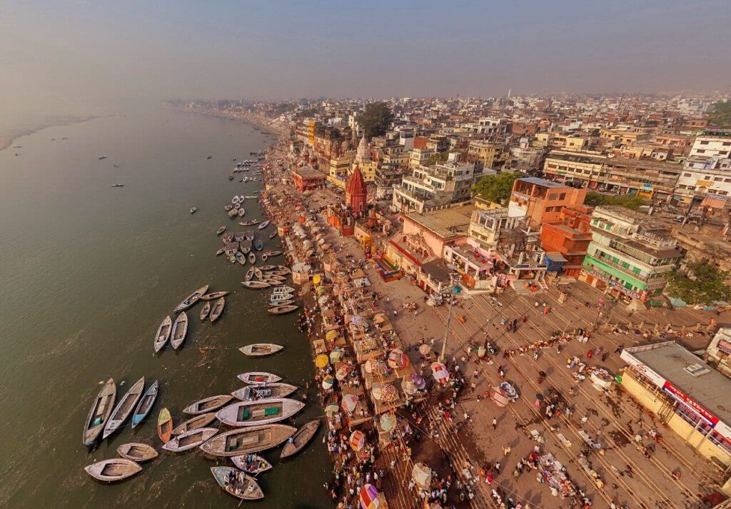
- Varanasi is one of the oldest cities in the world and India; it is considered a holy place in the world of Hinduism. The city is located in the state of Uttar Pradesh in the northeast of the country. It is inhabited by over 1.5 million people. For several thousand years Varanasi has been a city of ashrams, saints and scientists, the center of Theosophy and philosophy, medicine and education. Today, the city's life is concentrated on the Ganges embankment, the main attraction of which is the stone ghats: wide stone steps descending to the water and stretching for 5 km along the western coast. Their main purpose is ritual washing and cremation of the dead. Thousands of Hindus come to Varanasi every day to conduct funeral rites: funeral fires are never extinguished here (about 300 burnings daily). Ashes and remnants of unburnt bodies are sent into the river, which increases the toxicity of already highly polluted water. The environmental problem of polluted waters high in E. coli has resulted in high mortality, especially among Indian children.
Location: Varanasi, Uttar Pradesh, India.
Coordinates: 25°18′25″N, 83°00′22″E