Israel map
https://gcshelp.org/ru/novosti/mirovye-novosty/izrailj_prazdnuet_70_let_nezavisimosti.html
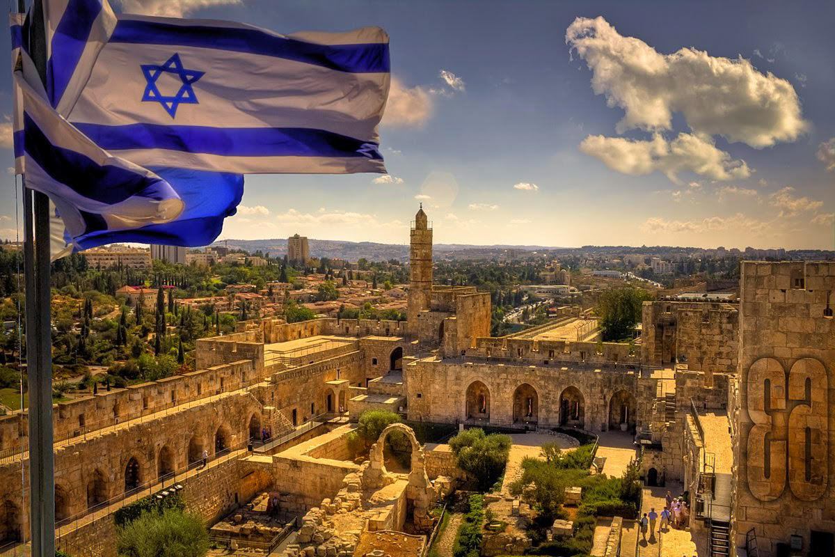
Israel is a land of shrines, a state with a rich cultural and historical heritage, diverse nature and amazing architecture of cities. An amazing country with an area of only about 20.8 thousand km² is located in the southwest of Asia. The population of this small country is 9.1 million people (74.1% Jews, 21% Arabs, 4.9% others).
Israel does not seek to officially determine its territorial boundaries and the rest of the world has its own views on this matter: there are several versions of the definition of the territory of Israel. The State of Israel has no officially fixed borders with Syria and Lebanon, and the rest of the borders are fixed by treaties. The capital is the city of Jerusalem.
In the west, the territory of Israel is washed by the waters of the Mediterranean Sea, the southernmost part of the country goes to the Gulf of the Red Sea of Aqaba. If we consider the territory of the state from the point of view of topography then it can be divided into several zones:
- Coastal plain (width from 1 to 32 km).
- Mountains and hills of Galilee, Judea and Samaria.
- Negev Plateau (desert that occupies 60% of Israel's area).
- Rift Jordan Valley.
The climate of Israel is often defined as a humid Mediterranean but the variety of relief, the proximity of various natural zones, form zones with their own microclimate. More humid in the north, deserted in the south.
- zone of moderately hot and humid climate (Carmel massif);
- hot and moderately humid climate zone (Central Highlands);
- arid climate zone (Negev, Jordan Valley);
- and an area with a desert climate (Arava Valley, Paran Upland, Dead Sea).
Annual precipitation rates range from 20 (Eilat) to 1080 mm (Galilee) per year. During the period from May to September there is very little rainfall.
Water temperature:
- in the Dead Sea (+20 in winter, +32 in summer);
- in the Mediterranean Sea (+17 in winter, +31 in summer);
- in the Red Sea (in winter +23, in summer +26).
Time zone: GMT + 2 (GMT + 3 in summer)
Israel is a democratic parliamentary republic with an actively developing economy. The economy of one of the most developed countries in Southwest Asia is based on the production of high-tech products, medicines, chemicals, textiles and others.
Since 2010, the State of Israel has become a member of the OECD.
Coordinates: 31°47′N, 35°13′E
Regions of Israel

There is no single administrative division in Israel.
Most often, the division adopted by the Ministry of Internal Affairs is taken as the official version:
7 districts (North, Haifa, Central, Tel Aviv, Jerusalem, South, Judea and Samaria);
- 15 subdistricts (nafa);
- 50 natural regions.
For the collection of statistical data, there is a separate division into three metropolises:
- Tel Aviv and Gush Dan
- Haifa
- Beer Sheva.
Tel Aviv District is the most populous district in Israel with a population of 1.4 million, 93% of whom are Jewish. The area of the district is 176 km², the administrative center is Tel Aviv.
The Southern District is the largest district with an area of 14.3 thousand km² and the smallest population density (77.77 people / km²). The population of the district is about 1.3 million people. The administrative center is Beer Sheva. Most of the territory is occupied by the Negev Desert and the Arava Valley. The district is known for the world's largest desalination plant.
Jerusalem District is a district with an area of 653 km² and a population of over one million inhabitants (1.1 million people). The administrative center of the district is the capital city of Jerusalem.
The District of Judea and Samaria, the second largest district (about 5.9 thousand km²) with a population of more than 413 thousand people. It is under the jurisdiction of the Central Military District of the Israel Defense Forces. Divided into 8 military districts. The area is better known as the West Bank.
The most interesting sights of Israel
About 5 million people from all over the world travel to Israel to worship shrines, touch the legends and secrets of mankind, and improve their health.
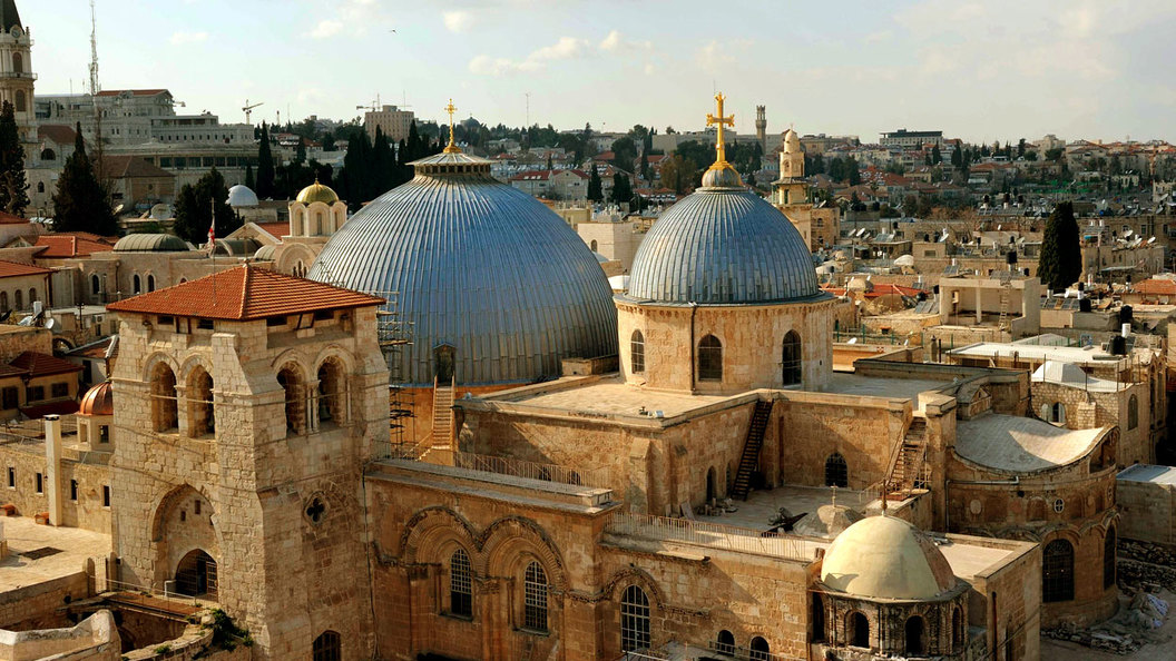
Church of the Holy Sepulcher
https://mir-piligrimov.ru/w1056h594fill/
The Church of the Holy Sepulcher is the main place of worship of the entire Christian world and the main attraction of the capital of Israel. Located in the Christian Quarter of the Old City, the temple is a single temple architectural complex, which includes:
- the church on Calvary with the place of the Crucifixion;
- Temple of the Resurrection;
- underground temple of the Finding of the Life-giving Cross;
- a rotunda with a large dome;
- Temple of Equal-to-the-Apostles Helena;
- side-altars, several monasteries, galleries and utility rooms.
The Church of the Holy Sepulcher is supposed to have been built on the site of the execution, burial and resurrection of Christ. Currently, the landmark is jointly owned by different denominations which gives rise to inevitable disputes. Chapels, the time of services are divided between 6 Christian churches: Greek Orthodox, Catholic, Ethiopian, Armenian, Coptic, Syrian. The keys to the main entrance have been kept by the Judy Arab dynasty for many centuries.
The temple was repeatedly destroyed during the hostilities which was one of the reasons for the start of the Crusades. In addition, the temple suffered from both earthquakes and a fire in 1808.
The facade of the temple is impressive with its beauty. Built in the 12th century Romanesque style, it was once decorated with bas-reliefs that are now on display in museums.
Every year the temple complex becomes a place of pilgrimage for millions of believers, especially on religious Christian holidays. On Great Saturday, on the eve of Easter, a huge number of people gather to participate in a special service: the Descent of the Holy Fire.
Location:1 Helena Str., Old City, P.O.B. 186, Jerusalem, Israel
Coordinates: 31°46′42″N, 35°13′47″E
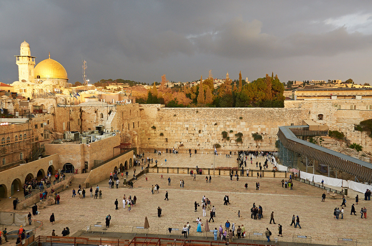
Wailing wall
http://fotokto.ru/photo/view/2197563.html
The Western Wall is a part of the 485 m long ancient wall which is located in the Old City of Jerusalem, on the western slope of the Temple Mount. The Temple Mount is a rectangular area (480 m X 300 m) which is surrounded by a high wall. The height of the wall reaches 45 m. This place is the most important symbol of the faith of the Jews.
Part of the wall extends (57 m) onto a large area of the Western Wall and is set aside for prayers. The rest of the wall is enclosed by numerous and dense buildings that cover the slopes of the Temple Mount. The wall consists of 45 layers of stone (28 above ground and 17 underground).
The main shrine of Judaism: the Western Wall. It is the holiest place, revered as the only thing that remains of the Holy Jerusalem Temple which in the period of X century BC - I century AD was the center of the religious life of the Jewish people.
At any time of the day at the wall you can see people bringing their prayers: prayers of gratitude or prayers for mercy. The Square at the Wall is divided into two parts: for women and for men. At the Western Wall, Jews mourn the destruction of the Great Temple, ask for the revival of Israel's former greatness, and express hopes for its future. About 300 years ago, the tradition came to leave prayer notes in the cracks of the Western Wall. Their number reaches 1 million annually.
Location: Western Wall Plaza, Jerusalem, Israel
Coordinates: 31°46′35″N, 35°14′00″E
Zion
https://littletravel.ru/6-bezvizovyh-stran-kotorye-stoit-posetit-etoj-zimoj/
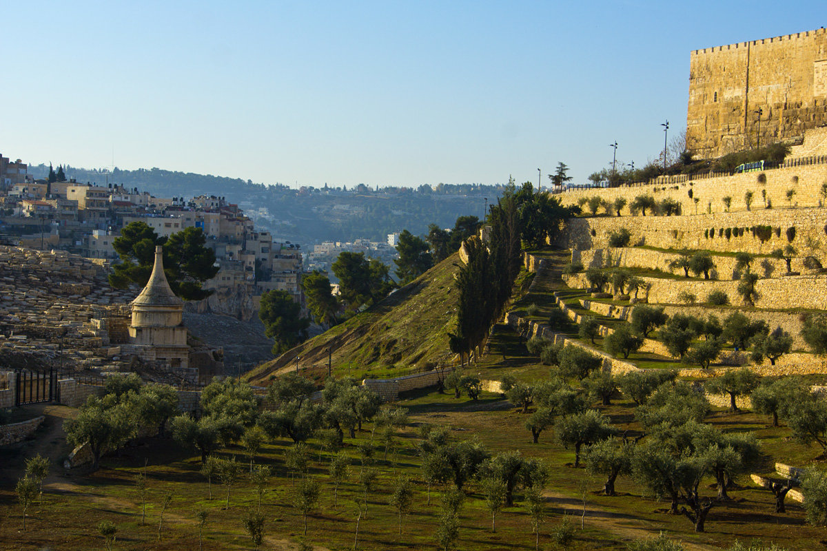
Zion is the highest mountain in Jerusalem (height 765 m). In the modern sense, Zion (Holy Mountain) represents the southern part of the western slope of the green hill of Jerusalem, located outside the Old City.
Mount Zion is not only a religious landmark but also a symbol of the Promised Land.
At the top of the mountain is the Zion Gate - the beginning of the path to the holy places. The first shrine on the way is the tomb of King David. This place is deeply revered by Jews, Christians and Muslims alike. During the occupation of the territory of Israel by Jordan (1948-1967), the Old City and the Wailing Wall in Jerusalem were inaccessible, and the Jews went with prayers to Mount Zion, to the tomb of David. The tomb is located next to the last of the seven ancient synagogues.
- The Zion chamber is located directly above the tomb of King David. It was here, according to legend, that the Last Supper (the last meal of Jesus and his disciples) took place, during which the sacrament of the Eucharist (the consecration of bread and wine) was born.
- On the day of Pentecost, the descent of the Holy Spirit took place in Zion.
- For many years Jerusalem Christians gathered in secret in Zion.
- Here lived John (a disciple of Christ), in whose house the Mother of God lived (on the top of the mountain, a Catholic church was built from the monastery of the Assumption of the Holy Mother of God).
- The world famous Oskar Schindler is buried in the Catholic cemetery, who saved about 1200 Jews from death during the war.
Today, the Holy Mountain is hidden from sight by numerous buildings but it still remains a place of attraction for all believers in the world.
Location: the Old City of Jerusalem, Israel
Coordinates: 31°46′18″N, 35°13′43″E
Masada National Park
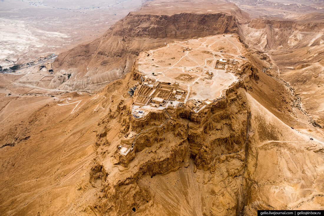
https://picworld.ru/?p=42758
On the southwestern coast of the Dead Sea, near the city of Arad, stands the majestic fortress of Masada. The fortress-refuge was built in 25 BC on one of the rocks of the Judean Desert at an altitude of 450 m.
The top of the cliff is crowned by a plateau (600x300 m), around there are steep cliffs. A narrow “snake” two-kilometer path from the sea leads to the fortress (the shortest and most popular among tourists with a climb of 310 m). The entire perimeter of the plateau is enclosed in the embrace of powerful walls 4 m wide, the total length of which is 1400 m. There are 37 towers installed along the wall. A mini-city was created inside the walls with an elaborate water supply system:
- palaces;
- synagogue;
- weapons depots;
- many auxiliary buildings.
One of the highlights of a visit to the attraction is the night light show which heightens the impression of the legend of Masada. According to historical records, Masada became the last stronghold of the rebels in Judea which lasted for several months. After that, 960 unbroken rebels, including women and children, met their death at the hands of their comrades in order to remain free and not become slaves of the Romans. The last rebel set fire to the fortress and committed suicide.
The show is organized on Tuesdays and Thursdays after sunset.
Today on the territory of the fortress there are:
- King Herod's palace
- synagogue
- water reservoirs in the rock
- baths
- ruins of a Byzantine monastery.
Location: Road 90, Ein Gedi, Israel
Coordinates: 31°18′56″N, 35°21′13″E
Mini Israel
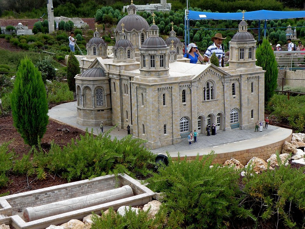
https://www.neizvestniy-geniy.ru/cat/photo/Pute/444770.html?addLike=-1
A unique miniature park 50 km from Jerusalem in the town of Latrun in Israel is the subject of interest of millions of visitors to the country. The open-air museum has collected 385 miniature copies of the most famous masterpieces of architecture, monuments and natural attractions of Israel. The park was opened in 2002 and is one of the largest miniature parks in the world.
The park in the form of a 6-pointed star (Star of David) covers an area of 6 hectares, of which 3.5 are reserved for miniature exhibits.
Most of the exhibits created by masters of the highest class are mobile. More than 50 thousand real plants have been planted on the territory of the park which were specially bred by scientists, the project engineers created an exclusive irrigation system. About 3.5 thousand cars move on mini-roads, 175 boats and ships on water, 32 planes are at airports, 14 trains run on a kilometer railway.
The sacred land at a glance allows you to immerse yourself in the atmosphere of the country and at the same time “visit” a large number of the most significant sights of Israel.
Location: Israel, Domaine de Latroun, Ayalon Valley, Hativat 7 Junction.
Coordinates: 31°50′32″N, 34°58′02″E
Gan Hashlosha
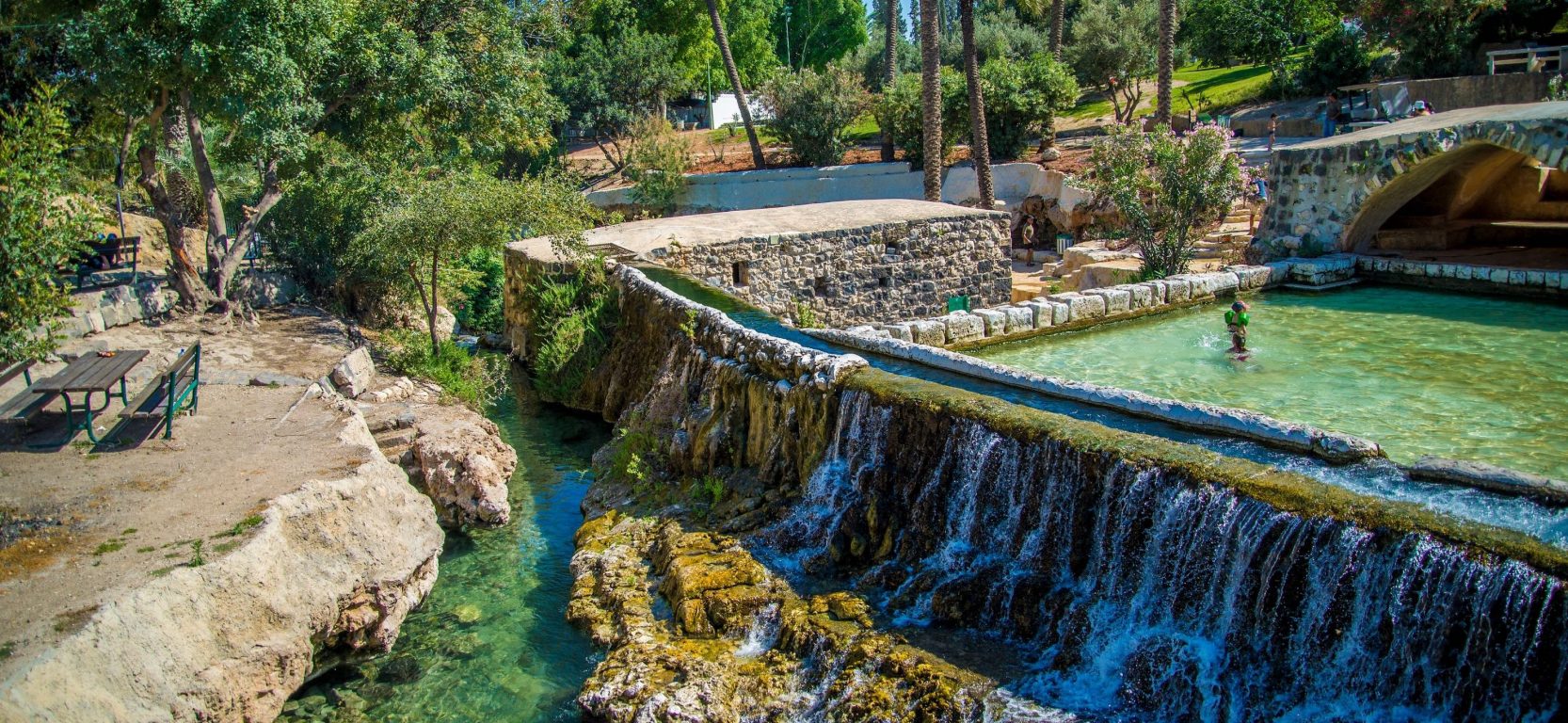
https://tourweek.ru/countries/israel/beit_she_an
Gan Hashlosha National Park is one of the most beautiful places in Israel, included in the TOP-20 most beautiful parks in the world according to Time magazine. The park is located in northern Israel, at the foot of Mount Gilboa, in the Beit She'an Valley, 5 km from the city of Beit She'an.
The main attraction is the Amal Stream, flowing from the west through a series of waterfalls into three natural pools. The water temperature of the brook and the pools is 28 ° C all year round.
The park also houses:
- The Wall and Tower Museum of Contemporary History. A reconstruction of the first settlement of Tel Amal with a watchtower and double palisade, founded in 1936. The pioneer huts illustrate the settlers' lifestyle.
- Museum of Regional and Mediterranean Archeology. The museum was founded in 1963 with a donation from Dan Lifshitz, a Jewish collector from Switzerland. The museum exhibits antiquities from the Neolithic period to the Mishnah and Talmud periods, including items from the anti-Roman uprisings and from the ancient synagogues that flourished in the area.
- Ancient flour-grinding water mill. Driven by the current of the Amal stream. It has been reconstructed and functions in the same place. It is used to demonstrate to groups the process of making flour and everyday life of those times.
- Remains of a Roman water theater (naumachia). On the southern bank of the stream, the remains of 10 rows of seats carved into the rock were found. During Roman times, this may have been a "water theater": a gathering place for the public to see recreated often bloody historical battles and events that originally took place at sea. Researchers estimate that the theater would have 500 seats.
- Garden of Bells. An exhibition of restored bells with specimens found in pioneer settlements throughout the country. Bells were rung in the event of an attack or fire, and workers were called upon to eat. In religious settlements, bells were also used as a call to prayer.
- Israelite Orchard. An orchard that contains the species of trees mentioned in the Bible, such as figs, vines and pomegranates as well as fruit trees and shrubs that were typical of the early days of the settlement. In a gazebo entwined with a vine, visitors can enjoy peace and quiet.
Location: near Kibbutz, Nir David, Israel
Coordinates: 32°30'20"N 35°26'52"E
Yad Vashem
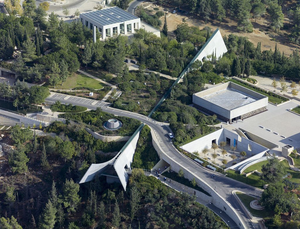
https://fr.timesofisrael.com/israel-va-remettre-pour-la-1e-fois-la-medaille-de-juste-decernee-a-un-arabe/
Yad Vashem is a National Memorial to the Holocaust and Heroism. It was founded in 1953 in memory of 6 million Jewish victims of Nazism. It is located on the western slope of Mount Herzl, at an altitude of 804 meters above sea level and covers an area of 18 hectares. This is the second most visited attraction in Israel: more than 1 million people come here to honor the memory of the victims.
The memorial complex includes:
- Holocaust History Museum (9 galleries);
- Memory wall;
- Children's memorial (a cave carved into the rock, under the arches of which the names, ages and place of birth of children destroyed by the Nazis are heard);
- Hall of Memory;
- Partisan panorama;
- Column of Heroism;
- Memorial to the Deported Cattle Car;
- monument to Jewish soldiers;
- sites: Hope Square, Valley of the Communities, Family Square, Janusz Korczak Square, Warsaw Ghetto Square;
- Museum of Holocaust Art;
- Garden of the Righteous of the World (a tribute to the memory and respect of the fighters against Nazism of non-Jewish origin, who chose the path of saving Jews during the genocide);
- synagogue;
- Research Institute;
- library with archives;
- publishing house;
- International School of Holocaust Research.
Yad Vashem is a place that touches to the depths everyone who steps on the territory of the memorial. All the pain of the Jewish people is captured here.
Location: Yad Vashem, The Martyrs' and Heroes' Remembrance Authority, P.O.B. 3477, Jerusalem, 9103401, Israel
Coordinates: 31°46′26″N, 35°10′29″E
Major airports in Israel
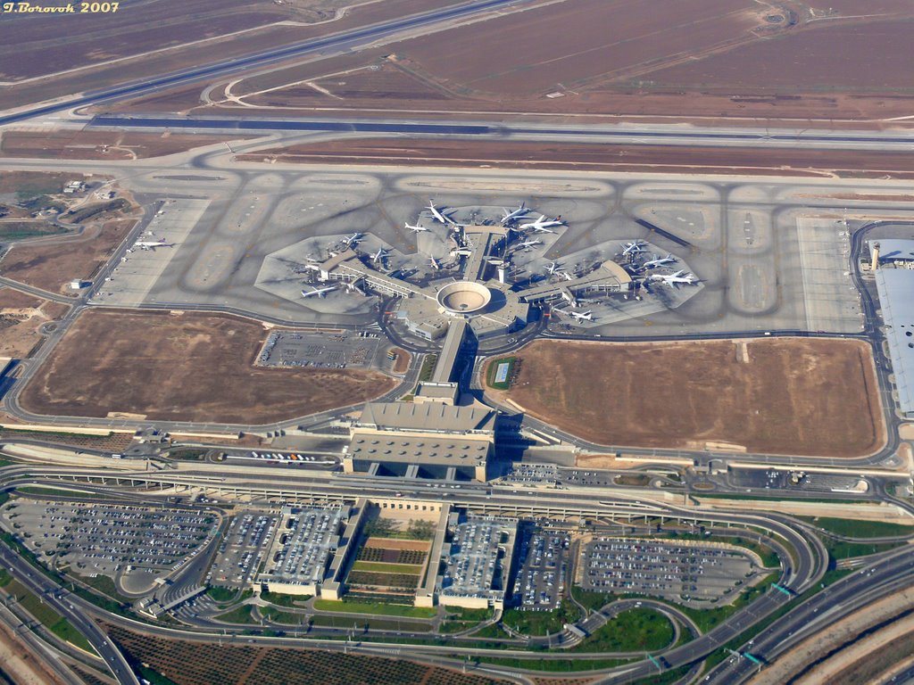
https://www.theyeshivaworld.com/news/headlines-breaking-stories/337714/jumbo-jet-makes-a-safe-touchdown-at-ben-gurion-amid-massive-ems-response.html
Air control at Israeli airports is administered by the Israel Air Force with the exception of Ben Gurion Airport. Three airports have international status. External and internal flights are operated by El Al, Arkia, Israir and others.
Currently operating:
- cosmodrome;
- 19 civilian airports (the main ones are under the jurisdiction of the Israel Airports Authority);
- 8 military airports (Israel Defense Forces jurisdiction).
|
|
|
|
|
|
|
|
|
Israel Railways 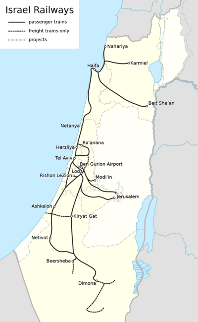
https://ja.wikipedia.org/wiki/イスラエルの鉄道
Israeli Railways (Rakevet Israel) is the main operating company that carries out passenger and freight rail services in the territory of the state. The total length of the railway line is 1138 km. The railway network diverges in different directions from the densely populated coastal area and includes 68 highly technically equipped stations. Cycle parks have been built at the stations.
Train travel in Israel is considered one of the most comfortable and affordable. The movement of trains is carried out around the clock. There are no trains on Shabbat and religious holidays. Passenger trains carry about 4 million people per month.
Communication with other countries is currently unavailable.
|
|
|
|
|
|
|
|
|
Highways of Israel
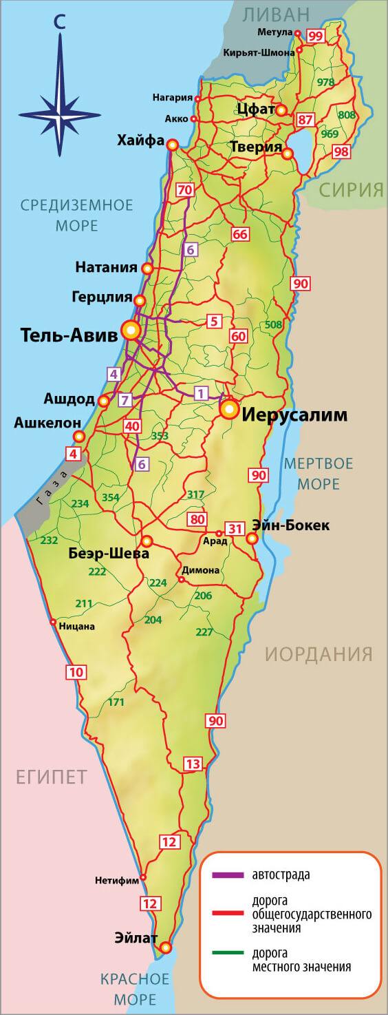
http://www.kruzo.com/blog/user/name/candlekeep/rasstoyaniya-mezhdu-gorodami-v-izraile.html
An extensive road network covers the entire territory of Israel. Currently, the total length of paved roads is about 20 thousand km.
In Israel, a 4-category road classification has been adopted:
- Motorways (expressways). They are numbered with one digit;
- Intercity highways (two-digit numbering);
- Regional roads (three-digit numbering);
- Local roads (four-digit numbering).
There are 43 active highways in Israel: 3 expressways, 4 partly expressways, a tunnel and 35 highways.
The Trans-Israel Highway (Highway 6) and the Carmel Tunnel (Highway 23) are the only toll roads.
Motor transport is the most popular form of transport among local residents: almost everyone has their own car. Public transport is relegated to the background. Markings and road signs on the roads are informative and very clear, convenient parking.
Editor's Choice: Dead Sea
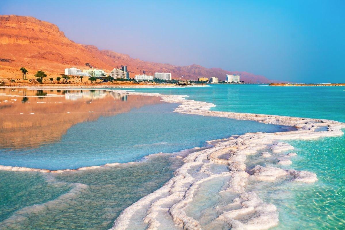
https://smarty.sale/news/gde-otdohnut-letom-2019
Israel is a country where people go not only for spirituality but also for health. The best place to improve your health is in the very unusual Dead Sea.
The Dead Sea is one of the saltiest bodies of water in the world (salinity is 300-310 ‰) and the coast is the lowest point on the planet. The sea is 67 km long, 18 km wide, and the depth reaches 306 m. Apart from some types of bacteria, no living organism is able to survive in such a salt concentration. Therefore, the sea was called Dead.
The mineralogical composition of the Dead Sea salt differs significantly from the composition of the salt of other seas. Therefore, the water of the Dead Sea has healing properties and silt sulphide mud from the bottom cleanses the skin, relaxes muscles, strengthens blood vessels. You can stay in such water, saturated with elements, for only 40-60 minutes a day (20-30 minutes per entry). The amount of salt makes the water very dense which allows the body to stay in the water without exerting any effort. Therefore, sometimes it’s called the "Asphalt sea". Diving in such water will not work. The only major source of fresh water flowing into the sea is the Jordan River.
Water temperature: +23 in winter, +33 in summer. Tourist peak: March-April.
Today, the natural resources of the unique sea are mercilessly exploited by industry which leads to a constant drop in the water level of the groundwater, and the level of the sea itself drops on average by 1 meter per year. With this state of affairs, an ecological catastrophe is imminent: a decrease in water levels, sinkholes, pollution.
Location: Israel
Coordinates: 31°29′27″N, 35°28′47″E