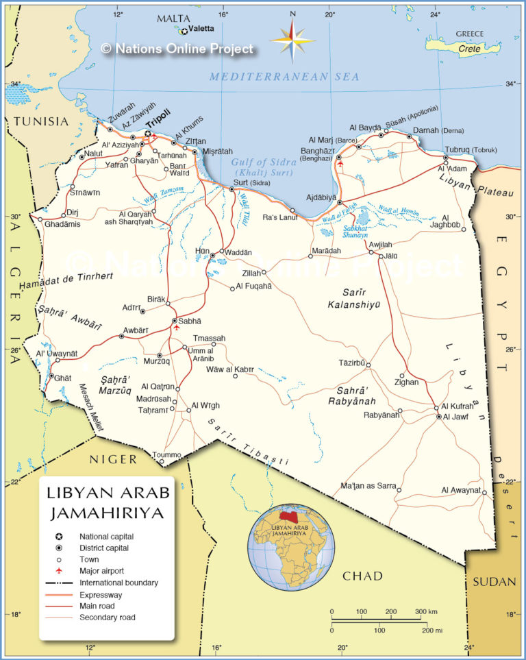
Libya map
 https://oko-planet.su/politik/politiklist/633585-madzhdi-shabaani-zaderzhali-po-ukazu-pns-podrobnosti.html
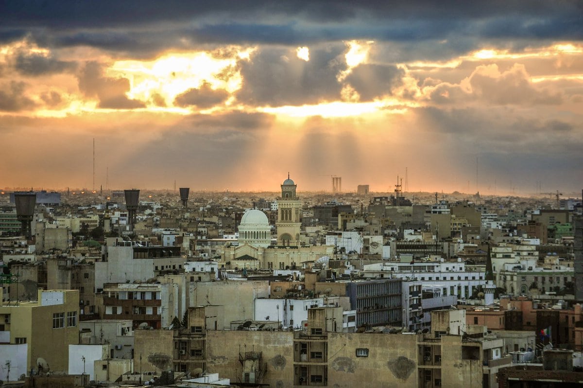
The state of Libya is the fourth largest country in Africa (area of 1,759,541 km²). The fairly homogeneous population of the country is more than 7.2 million people (population density is only 3.2 people / km²). About 2 million inhabitants of the capital Tripoli.
Libya is located in the north of the African mainland on the Mediterranean coast and has the longest coastline (1,770 m) among the Mediterranean countries. It shares borders with Algeria (west), with Chad and Niger (south), with Egypt (east), with Sudan (southeast). The total length of the land border is about 4.3 thousand km.
The highest point is Mount Bikku-Bitti (height 2267 m). Located on the Tibesti mountain plateau in the south of the country. 90% of the territory is occupied by the desert therefore the flora and fauna are poor: 80 species of mammals (5 endemics), 360 species of birds, Mediterranean shrubs, Aleppo pine, juniper, cedar. The rivers are filled with water only during the period of rare rains.
Historically, the country is divided into three parts:
- in the west of Tripolitania (area 350 thousand km²);
- in the east of Cyrenaica (about 850 thousand km²);
- in the south of Fezzan (about 550 thousand km²).
The climate in Libya is predominantly dry with a large difference in daily temperatures: mostly tropical and subtropical (in the north). Average temperature on the coast: in winter + 11 …… + 12 (January), in summer - + 26…. + 29 (July). In other regions, summer temperatures reach +36 during the day and 0 at night. There is little rainfall (less than 100 mm per year) and only in certain areas on the coast up to 400-600 mm per year.
Tourist season: November to March. Beach tourism is not well developed.
Time zone: UTC +2.
Libya is officially a republic but in reality a paramilitary dictatorship has been established in it. In March 2021, the state was ruled by the Government of National Unity (interim government) which eradicated the dual power in the country. In fact, a paramilitary dictatorship has been established in the officially recognized republic of Libya.
The economy is based on oil and gas production. The lack of large areas for agricultural development is compensated by the ability to harvest several crops a year but even this does not meet the country's food needs. With a fairly developed manufacturing industry (mainly metalworking and machine-building enterprises), Libya is the main supplier of weapons in Africa and a profitable and promising market for weapons sales. In addition, the country remains interesting to the world community as one of the largest suppliers of oil and natural gas.
GDP is 30.2 billion dollars (4.6 thousand dollars per capita).
Tourism fell into disrepair caused by years of civil war. Scattered parts of the country are at war with each other from time to time. Today Libya does not issue tourist visas which is why it is considered the most closed country in the world. It is extremely difficult to obtain a business visa and it is just as difficult to get to Libya itself. The official government controls only Tripoli.
Alcohol has been banned since 1969. The punishment is imprisonment.
Coordinates: 27°25′N, 17°47′E
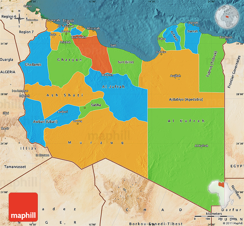
Regions of Libya
Libya is administratively divided into 22 municipalities, each of which has its own specifics and standard of living.
(Gat, El Kufra, El Jufra, Wadi El Hayat, Wadi El Shati, Marzouk, Nalut, Sabha, Sirt, El Butnan, Derna, El Wahat, El Mar, El Jabal Al -Akhdar, El-Nugat-El-Khums, Ez-Zaouia, El-Jabal-El-Garbí, El-Margen, El-Jirafa, Misurata, Benghazi, Tarabulus (Tripoli)).
- Tripoli is the smallest in area (835 km²) but the most populous municipality (population over 1 million inhabitants). The administrative center is Tripoli. It is a large industrial and commercial center of the country, the main seaport..
- Al-Kufra is the largest (area 483.5 thousand km²) municipality while occupying the penultimate place in terms of population (50.1 thousand people). The administrative center is Al-Jaf. Located in the center of the Sahara Desert and is a key point on the West-East route through the desert.
- El Jufra is a municipality in the very center of the country, ranked third in terms of area (more than 139 thousand km² with a population of 52.3 thousand people). Historically, it became known as the largest oasis in the Sahara Desert (oasis lands are about 2 thousand km ²). The administrative center is the city of Sokna. Due to its location, trade has always been a strong foundation of the economy.
- Benghazi is the second most populous municipality. More than 670 thousand people live in an area of 11.3 thousand km2. The administrative center is Benghazi (the second largest city in the country). Benghazi is also the capital of the historical region of North Africa: Cyrenaica which occupied the northeastern territories of the modern state of Libya.
https://conyersinthehous.blogspot.com/2018/12/libia.html?m=1
The most interesting sights of Libya
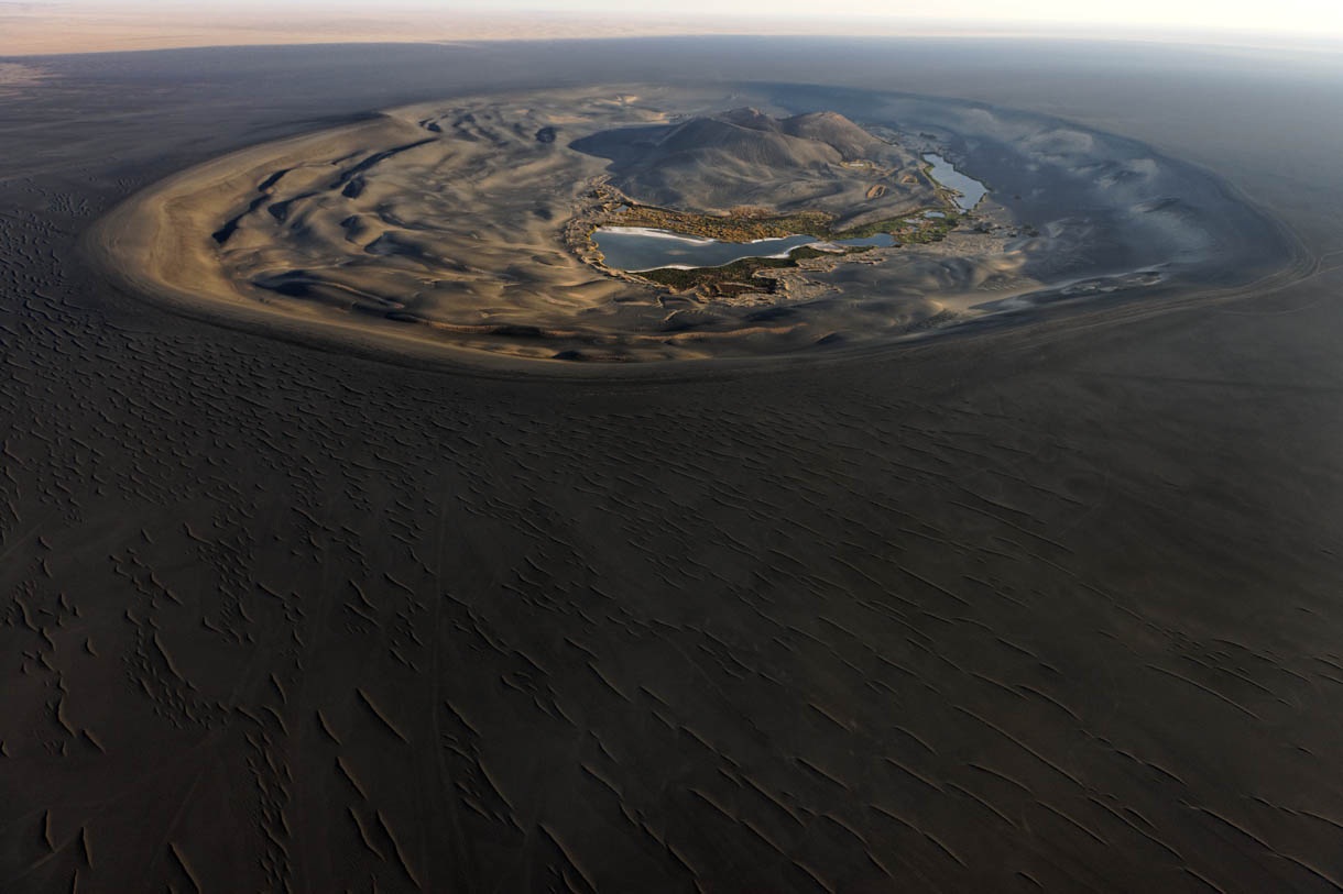
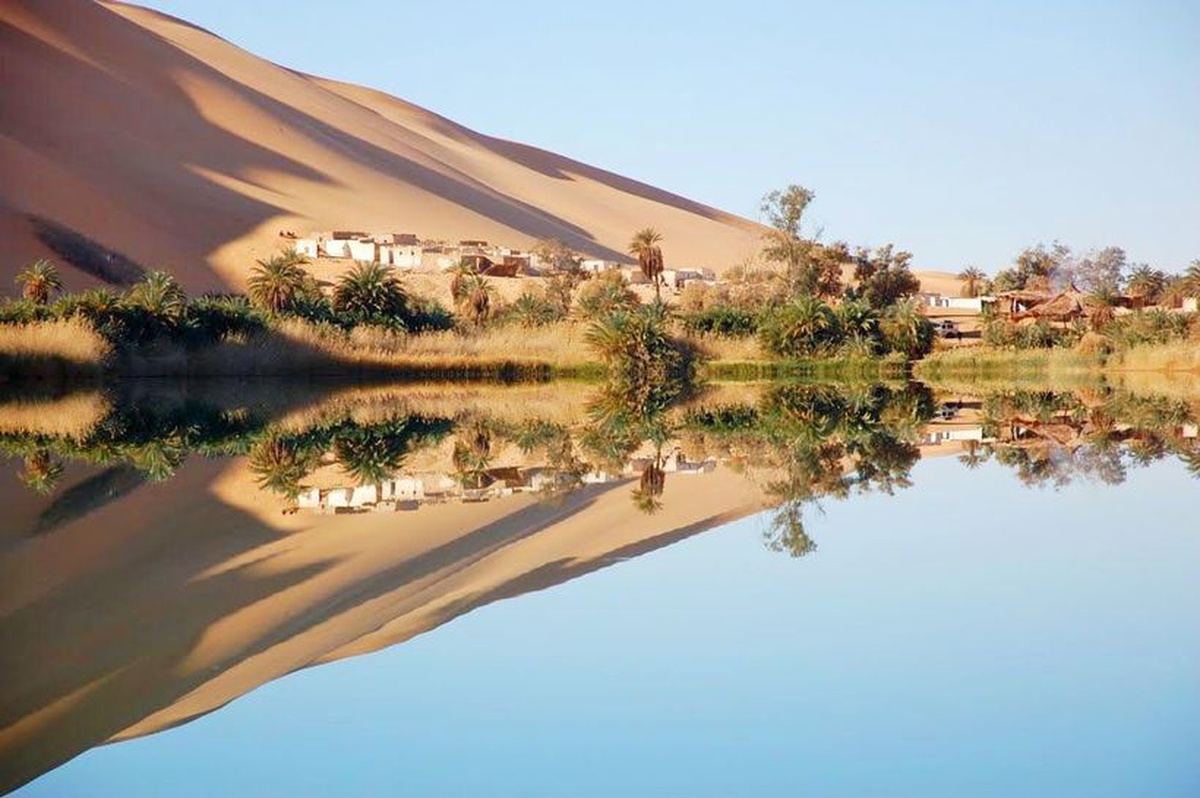
Oasis Ubari. Lake Umm-Al-Maa. Lake Gaberoun.
https://masterok.livejournal.com/1221232.html
Ubari Oasis is located in the southwest of the country in the Sahara Desert (Wadi al-Hayat municipality). Local residents: Tuaregs belong to the Berber group of tribes and are distinguished by their belligerence. But today the population of Ubari lives mainly on nomadic herding.
Oasis Ubari is one of the most beautiful oases in the world. On its territory there are 11 salt lakes surrounded by lush vegetation which were once part of a large aquatic ecosystem. Today the lakes are subject to gradual drying up as they have no external recharge. Salt is mined in their waters (the salt content is close to the amount of salt in the waters of the Dead Sea).
The oasis is a popular and frequently visited destination for tourists. Favorable months to visit: October to May.
Location: Libya
Coordinates: 26°35′06″N, 12°46′12″E
https://about-planet.ru/priroda-afriki/pustynya-sakhara
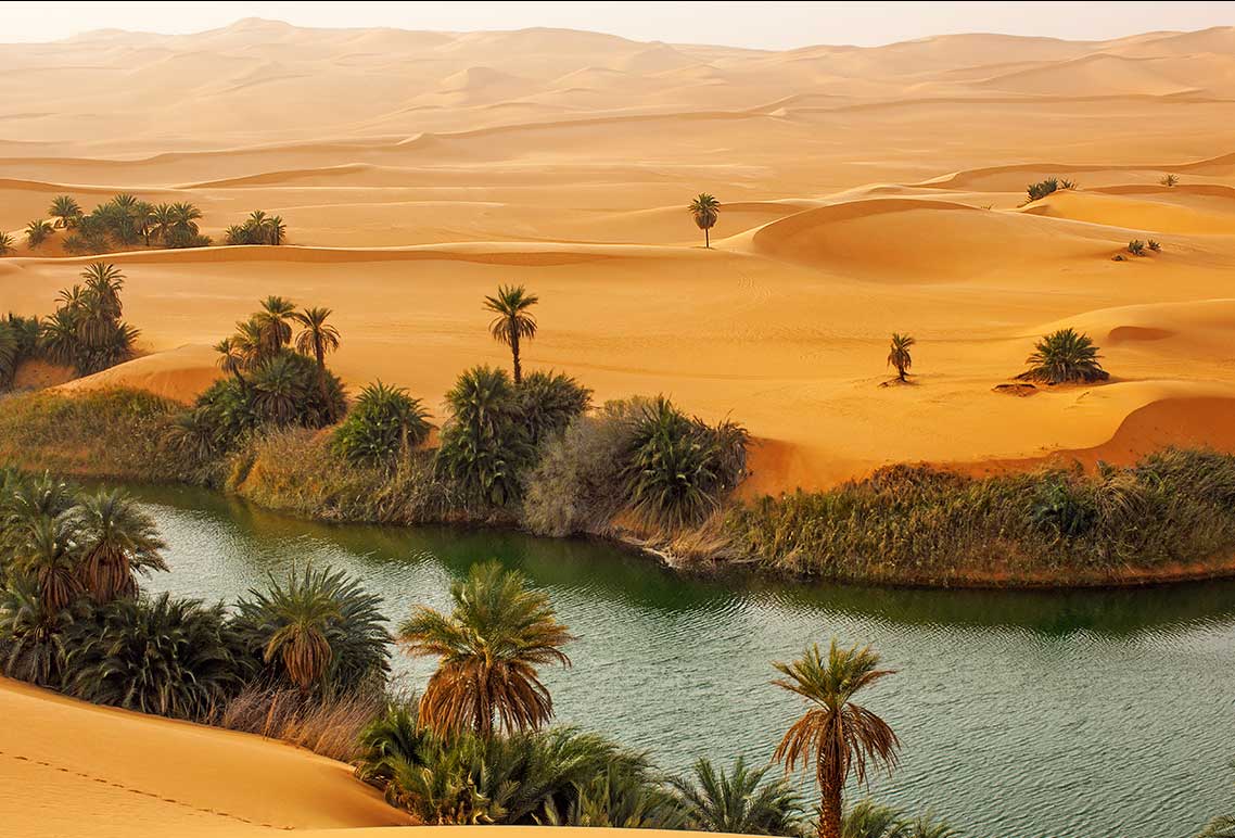
The largest lake in the Ubari oasis is Lake Umm Al-Maa (Mother of Water). The water in the lake is very salty, saturated with various minerals and its layers have a large temperature difference: the lower layers of water are hot and can reach +100, the upper ones are always cold.
Location: Libya
Coordinates: 26°42′40″N, 13°20′11″E
https://mobile-business.by/statyi/strany-goroda-kurorty/zhemchuzhina-pustyni-7-samykh-krasivykh-oazisov-mira
One of the largest lakes in the Gaberoun oasis is surrounded by a green ring of palm trees. The salt content of its waters is five times the amount of salt in seawater.
On the northeastern shore of the lake there is a tourist camp, on the territory of which a souvenir shop is open. It features traditional Berber handicrafts and jewelry. On the west coast are the ruins of an old Bedouin settlement.
Location: Libya
Coordinates: 26°48′11″N, 13°32′07″E
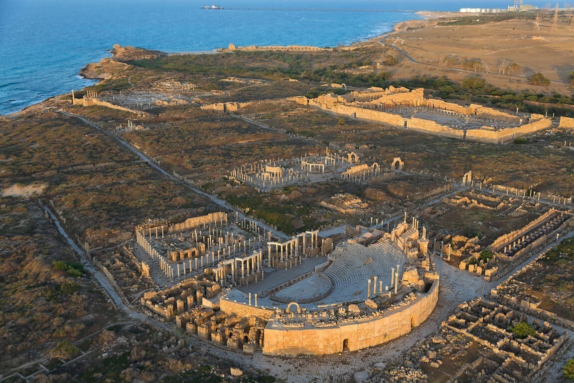
Leptis Magna Ancient Museum City
https://fishki.net/3403758-leptis-magna--drevnejshij-gorod-livii.html
A unique UNESCO World Heritage Site, the ancient city of Leptis Magna in Tripolitania (130 km east of Tripoli) is today a famous open-air museum. The exact date of the founding of "African Rome" (Phoenician colony) is unknown but scientists presumably call it 1100 BC.
The oldest city in Libya played an important role in the formation and development of the Libyan state:
- reaching its heyday after 193, it became the capital of the empire;
- was the main port;
- was one of the richest cities in Africa and the Mediterranean;
- as well as a major trade, cultural center, exporter of ivory, local products and exotic animals. Well-preserved ruins allow you to touch the greatness of Leptis Magna:
- fragments of buildings,
- columns,
- remains of foundations,
- forum and basilica,
- causey on a wide (18-meter) avenue
- and the baths of Hadrian, decorated with elaborate mosaics.
The flow of tourists (before the closure of the country) was insignificant, despite the majesty and significance of the attraction, it was small. Mainly archaeologists were interested in the architectural monument.
On the territory of the ancient city there is a museum which contains antique sculptures, the world's largest coin warehouse, etc.
Location: Al Khums Road, Tripoli, Libya
Coordinates: 32°37′48″N, 14°18′44″E
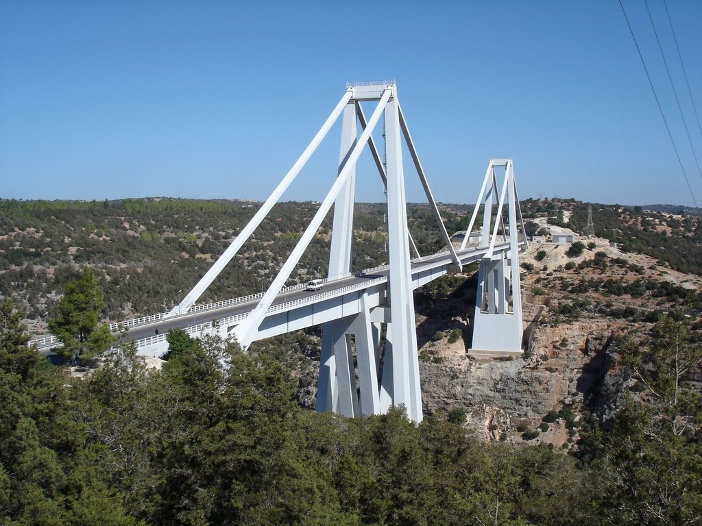
El Kouf National Park
https://twitter.com/Mecra/status/1168199215622828032/photo/4
The most famous national park of Libya is El-Kuf. It is located on the territory of 350 km2 along the north-eastern Mediterranean coast of the country (the length of the coastline is 20 km). The park was founded in 1975 and is part of the seven national parks of Libya.
On the territory of the reserve:
- 90% of all representatives of the flora of Libya;
- diverse marine and terrestrial fauna;
- sand dunes, magnificent sea lagoons and beaches;
- rock massifs;
- basin of the Kuf river.
The park is located 150 kilometers from the city of Benghazi and attracts about 300 thousand tourists annually.
Wadi Al Kuf is the second highest bridge on the African continent. Located not far from the national park. Its length is 477 m, width 13.5 m, height 160 m. The span of 282 m has become the longest concrete cable-stayed bridge span in the world.
Location: Al Mare, Libya
Coordinates: 32°44′36″N, 21°12′18″E
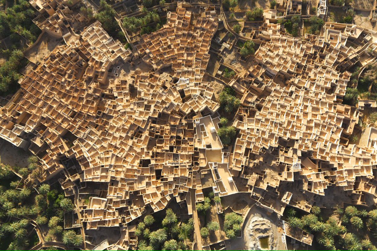
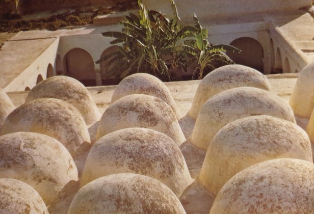
Ghadames town
https://www.da-magazine.co.il/wp-content/uploads/2019/12/CjiMWZzUkAAl2A0.jpg
Ghadames is one of the most ancient Berber cities in Africa. The city was built in the oasis of the Sahara Desert in northwestern Libya in a strategically important place at the intersection of caravan routes (area 38.4 hectares, population 10 thousand inhabitants, ethnic composition: Tuaregs).
Travelers of trade caravans found shelter from the heat in the oasis city which became known to the world as the pearl of the desert.
The old historical part of the city, surrounded by the city wall, has been a UNESCO World Heritage Site since 1986 (object No. 362) and is currently deserted. The city is divided into quarters, each of which belongs to a separate clan.
The entire architecture of urban buildings is unique and is aimed at making it possible for humans to exist in the high temperatures of the desert climate. The houses are built of earth, palm trunks, limestone, and painted white.
The internal architecture is subject to a clear functional division:
- lower floor for storing food supplies;
- the next floor with covered walkways is a family one;
- upper open terraces for women who were not allowed to leave the house unaccompanied by a male relative.
And now, in the summer, the former Roman fortress shelters its owners from the unbearable heat of the desert, who live in a new modern city nearby.
Location: Tripolitania, Libya
Coordinates: 30°08′N, 9°30′E
In-Naka Mosque in Tripoli.
https://libyacolonialhistory.wordpress.com/2019/07/22/libya-the-world-of-islam-festival-1976-to-the-present-day/
The oldest and most revered mosque in the Libyan capital is the In-Nika Mosque (Camel Mosque) in Tripoli. Officially, the building dates back to 1560 but, according to legend, the building was built in the X-XI centuries. The attraction is located in the southeastern part of the city.
The building has an area of 282 m². Built in the Libyan architectural style with one minaret, a large number of small domes (32 domes), laconic lines and simple decoration without inscriptions or carvings. The unique architecture distinguishes the mosque against the general background of the buildings of the capital city.
Location: Shari Jama ad-Draghut, Tripoli, Libya
Coordinates: 45°30′16″N, 73°33′22″E
Largest airports in Libya
Libya has developed both international and domestic air traffic. Today there are more than 50 hard-surfaced airfields.
|
|
|
|
|
|
|
|
|
|
|
|
The largest railway stations in Libya
All railways and stations in Libya have been dismantled and closed. But today there are intentions and plans to implement plans to restore the railway network in the country. In the future, it is planned to lay a railway along the entire coast: from the border with Tunisia to Egypt.
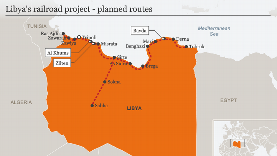
https://www.dw.com/en/libyas-train-project-remains-off-the-rails/a-19565824
https://www.reportdifesa.it/libia-haftar-tra-sirte-e-tripoli-manovre-politiche-e-militari-per-prendere-il-potere-del-paese/
Highways of Libya
The total length of roads in Libya is about 100 thousand km, highways are about 48 thousand km which connect almost all the cities of the country with a single network.
The main highway (Libyan Coastal Highway) which stretches 1,822 km from east to west along the Mediterranean coast of Libya (from Tunisia to Egypt), meets the highest quality standards for road surfaces. The highway is part of the Cairo-Dakar Route 1 (Trans-African Highway System).
Хорошо развито автобусное сообщение. К услугам населения такси и маршрутки.
Automobiles are the main mode of transport in the country. Almost every Libyan owns a car and Africa has the highest number of cars per capita.
Bus service is well developed. Taxis and minibuses are at the service of the population.
Editor's Choice: Jamahiriya
https://the-great-allied-soviet-war.fandom.com/wiki/Greater_socialist_people%27s_libyan_arab_jamahiriya
Jamahiriya (Arabic. Jamahir - the masses) is a non-standard form of the political and social structure of the state. The basics of the Jamahiriya were laid out by the leader of Libya: Muammar Gaddafi. In his three-volume Green Book where he substantiated in detail the advantages of the Jamahiriya as a state system.
The Great Socialist People's Libyan Arab Jamahiriya was formed on March 2, 1977. In 1988 the Libyan Jamahiriya adopted the Great Green Charter dedicated to human rights. After that, the regular army was abolished, replaced by the Jamahiriya guard.
The provisions of the Third World Theory of Gaddafi determined the implementation of the principle of direct democracy in the absence of the institutions of the president, parliament, government and party. "Jamahiriya is an era when everyone rules ... This is a society that embodies the dream of communism, anarchy, the City of the Sun" (M. Gaddafi).
The entire adult population of the country participated in the state administration of the Great Socialist People's Libyan Arab Jamahiriya and Gaddafi served as the Supreme Commander-in-Chief of the armed people. Many educated communes had full power, each in its own district but in reality Gaddafi ruled the country and no important decision was made without him.
On February 11, 2011, Libya held a "Day of Anger" which marked the beginning of mass unrest and became the starting point of a civil war between opponents and supporters of Gaddafi's rule. On October 20, the era of Gaddafi ended: the extraordinary revolutionary and leader of Libya, who challenged the world, was killed.
Libya became the only country in the world in which the Jamahiriya was the official form of government. But in some countries, for example, in Egypt and Tunisia, it is still the basis of statehood.