North Korea map
North Korea
https://liport.ru/politika/183899 – ec – vvedet – novye – sankcii – protiv – severnoy – korei.html
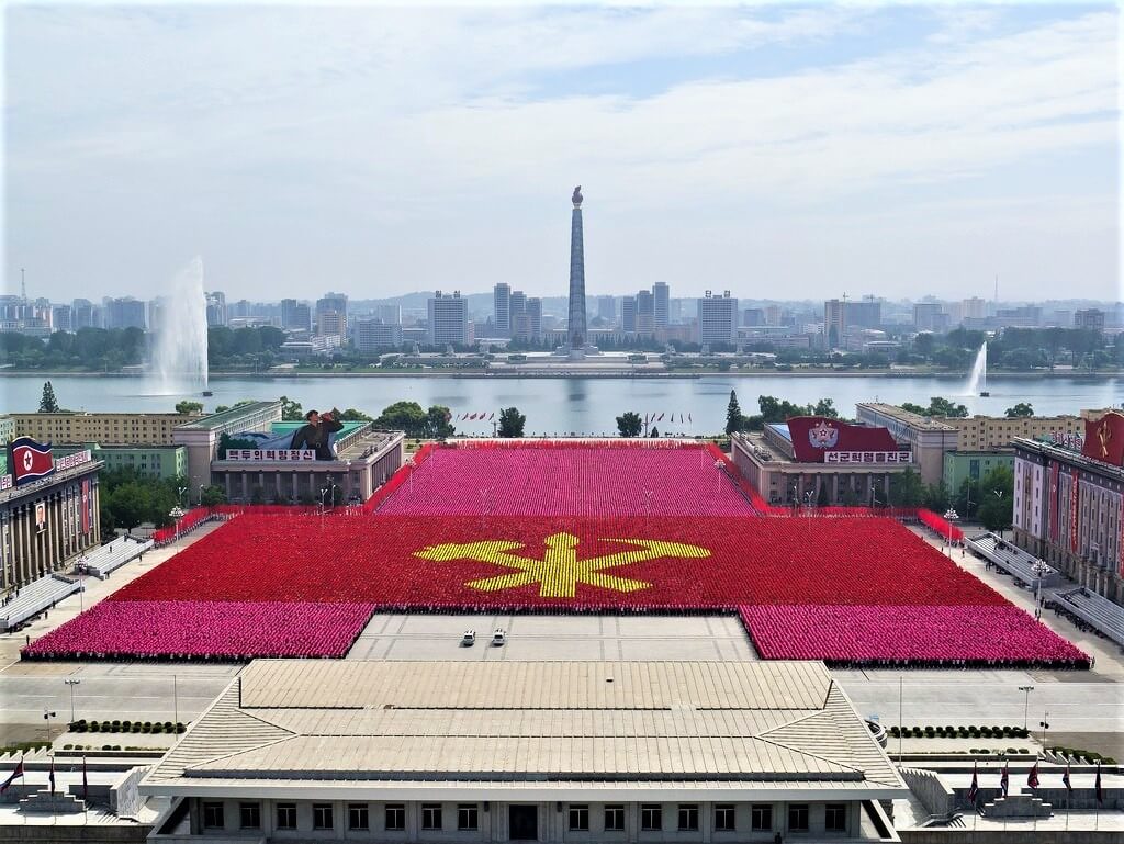
North Korea (officially - Democratic People's Republic of Korea) is a unitary state in East Asia, located in the north of the Korean Peninsula and covering an area of 120.5 th km². The capital Pyongyang is the country's only metropolis and the largest cultural and historical center. The mono-ethnic state is inhabited by more than 25.7 million people (99% are Koreans), of which the vast majority of residents are atheists.
The relief is predominantly mountainous (about 80% of the territory). The highest point is 2744 m – Pektusan volcano. The picturesque nature is carefully protected by numerous national parks and reserves. The flora is rich in various types of conifers, flowering shrubs, lianas (the core of the local plant world is made up of deciduous species of laurel, holly, Sieboldii magnolia). The fauna is diverse, and the reservoirs are rich in fish and seafood.
A developing industrial – agrarian state with a mixed economy (GDP $ 17.4 billion, per capita $ 685, a fairly high human development index of 0.766).
The climate is moderate monsoon with pronounced seasons and large fluctuations in day and night temperatures. Winters are cold and dry (stable snow cover only in mountainous areas). A short beautiful spring gives way to a long (almost 5 months) and rather hot summer with monsoon downpours. Daily temperature drops do not allow the sea water near the coast to warm up, and only in July and August it reaches +20. Autumn is short and rainy.
Favorable months for traveling to North Korea: April - May and September - October. Severe restrictions on visiting, the national policy of the state, the lack of Internet access on the territory of the DPRK led to the fact that tourism in the country is extremely poorly developed. Under the vigilant control, this "closed" country is annually visited by 4-6 thousand foreign tourists, for whom some regions of the country are inaccessible.
Time zone UTC + 9.
The DPRK is a sovereign socialist state actively waging a struggle against religion (a secular state). There are only two Orthodox churches in the whole country. In addition, North Korea is a vivid example of isolationism: the policy of non-interference in international affairs and the internal affairs of sovereign states. The DPRK emphasizes its independence by following the "Juche" - specially developed by Kim Il Sung (who ruled the country for almost half a century), the North Korean nationalist state ideology.
Coordinates: 39°44′56″N, 126°24′17″E
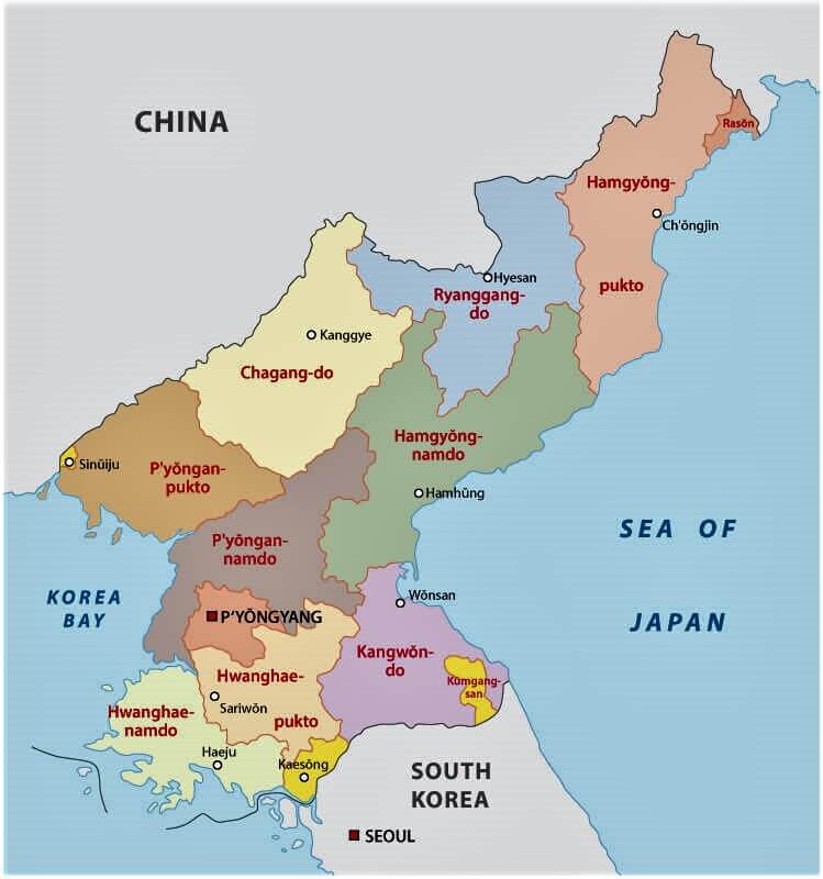
Regions of the country
https://www.turkey – visit.com/map – north – korea.asp
North Korea is divided into 14 administrative-territorial units:
- 9 provinces;
- 2 cities of direct subordination;
- 3 special administrative regions.
Provinces: (Chaganda, Hamgyong – Nam-do, Hamgyeon – Buk-do, Gangwon-do, Hwanghae – Buk-do, Hwanghae – Nam-do, Pyeong – Buk-do, Pyeongan – Nam-do, Yangando):
- Hamgyong-Nam-do is the largest in area (about 19 thousand m2) and the third most densely populated (more than 3 million people) province. The administrative center is the city of Hamkhyn. It is divided into 3 cities, 2 districts and 15 counties.
- Pyongan-Nam-do is the most densely populated province: the population is more than 4 million people in an area of 12.3 thousand square kilometers (5th place). The administrative center is the city of Pyongsong. Divided into 1 special city, 5 cities, 3 districts, 19 counties.
- Hamgyong-Buk-do (area 16.8 thousand km², population 2.3 million) is the historical homeland of most Koreans: the vast majority of local residents are ethnic Koreans. The administrative center is the city of Chongjin. Includes 3 cities, 16 counties.
Special cities (according to their status, they are equal to provinces):
- Pyongyang (area 315 km², population 4.1 million) is located on the banks of the Taedong River. The capital of the state, the largest city and the economic center of the country. It is divided into 19 districts. Rungrado 1st of May was built here. It is the largest multifunctional stadium in the world in terms of capacity (for 114 thousand seats).
- Rason (area 746 km², population 145.4 thousand people) is a large port, a railway transport hub. Divided into 1 municipal district and 1 county.
Special administrative regions (status equal to provinces):
- The Kaesong Industrial Region (66 km²) is located 10 km from the 4 km wide demilitarized zone separating North and South Korea. This is a scientific, technical and technological base for the implementation of innovative projects, uniting research institutes, business centers, exhibition zones, educational institutions. Since 2016, the activity of the technopark has been discontinued.
- Kumgangsan Tourist Region (area 530 km²) is the area around the Diamond Mountains (Geumgangsan Mountains), founded in 2002 after an influx of South Korean tourists. The resort area is located on the eastern coast of the Korean Peninsula. This is one of the most beautiful places in the DPRK.
- The Sinuiju Special Administrative Region (area 132 km²) is an experimental site on the border with China for the introduction of a market economy.
The most interesting sights of North Korea
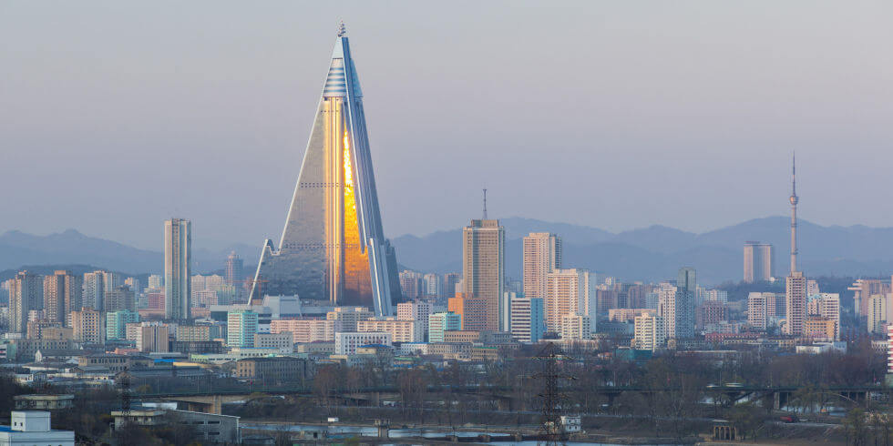
Hotel Rügen
https://m.brilio.net/brilistyle/wow/14 – bangunan – di – dunia – ini – punya – nilai – sejarah – tapi – dibiarkan – terlantar – 1609297.html
The Rügen Hotel, the construction of which began in 1987, is the tallest vacant building in the world and has not yet been commissioned. The name of the hotel comes from the old name of the capital: Rugen, Willow Capital. The building is designed in the neo-futurist style. Unrecognized by the world's leading architects, the “masterpiece” has an area of 360,000 m² and a height of 330m (105 floors, 3,000 rooms). The upper part of the triangular structure is a 40-meter round tower with 8 rotating lower floors. It is the largest and tallest building in North Korea. Around the skyscraper there is a green area: gardens and parks. Today, the unfinished building is used as a platform for propaganda light shows and is closed to the public. Hotel Rügen is considered the largest empty building in the world.
Location: Pyongyang, Democratic People's Republic of Korea (North Korea)
Coordinates: 39°02′11″N, 125°43′50″E
Korean Central History Museum
https://transphoto.org/photo/642587/
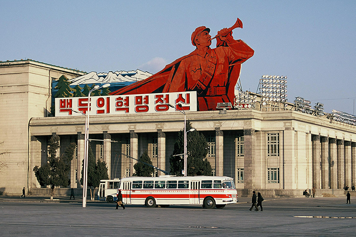
The Central History Museum of Korea, founded in 1945 in the capital of the DPRK, Pyongyang. The museum is located in the northern part of Kim Il Sung Square on the embankment of the Taedong River. The famous banner The Revolutionary Spirit of Paektu adorns the western façade of the building in the spirit of public policy.
The museum has an area of 10.5 thousand square meters and has 19 rooms (more than 100 thousand artifacts, works of art and materials related to Korean history since ancient times).
- Photo exhibition dedicated to famous people who visited the museum;
- Primitive period (halls 2 and 3);
- Ancient Joseon, Pue, Kurio and Chinguk states (halls 4 and 5);
- Collections from the Goguryeo era, 277 BC - 668 AD (6 - 9 rooms);
- Collections of the early feudal states of Baekje, Silla and Kaya (hall 10);
- Early feudal state of Palhe, 698 - 926 (Hall 11);
- History of the first unified state of Goryeo, 918-1392 (12-14 halls);
- Collections of the Li era, the last feudal state in Korea (1392 - early XX century) (rooms 15 - 17);
- Materials about the struggle of the Korean people against feudal oppression and external aggressors from the middle of the 19th century to our time (rooms 18, 19).
The research center at the museum conducts research on cultural values and organizes archaeological expeditions.
The finds from the Paleolithic and Bronze Age, like many other exhibits of the museum, are in the status of the National Treasure of the DPRK.
The museum participates in the exchange of experience with museums in other countries and actively cooperates with the World Organization of Museums.
Location: Kim Il Sung Square, Pyongyang, Democratic People's Republic of Korea (North Korea)
Coordinates: 39°01′12″N, 125°45′16″E
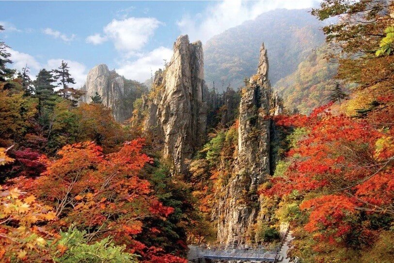
Mount Kumgang
https://travelask.ru/blog/posts/15122 – severnaya – koreya – sozdala – kalendar – na – 2019 – god – spetsialno – dly
On the east coast of the Korean Peninsula, the small mountain range Geumgang stretches for 80 km, which is part of the Taebaek mountain range. The maximum height is 1638 m - Mount Birobong. It is one of the most beautiful and popular destinations in North Korea. The Kumgan massif is divided into three parts: Outer (New - Kum gang), Inner and Sea Kum gang (Hae - Kum Gang).
The resort area was first opened in 1998, and in 2002 the Kumgangsan tourist region with an area of 530 km² became a separate administrative unit. The mountain park stretches 60 km from north to south, and 40 km from west to east.
The mountain range includes more than 12 thousand stone formations of bizarre shapes, formed by erosion. Unusual relief with a unique geological composition, pristine lakes, waterfalls, springs, and beautiful forests have made this natural attraction one of the most popular among guests and residents of North Korea.
The Kumgang mountains are called differently depending on how their appearance changes with the seasons: Diamond Mountains in the spring , Ponnesan (mountains where gods live) in the summer, Phunaksan (mountains without clothes) in the fall, Kegolsan (mountains that have opened their “bones”) in winter.
The diverse flora and fauna of the mountain range numbers 2,260 plant species and 390 animal species.
Buddhist shrines deserve special attention: surviving Buddhist temples are Phehun, Chang'an, Zhongyan, Singe, Yuchom; statues of Buddha Megir (the largest image of Buddha carved into the rock), a sculpture of three Buddhas.
Location: Kangwon Province,Democratic People's Republic of Korea (North Korea)
Coordinates: 38°31′34″N, 128°03′06″E
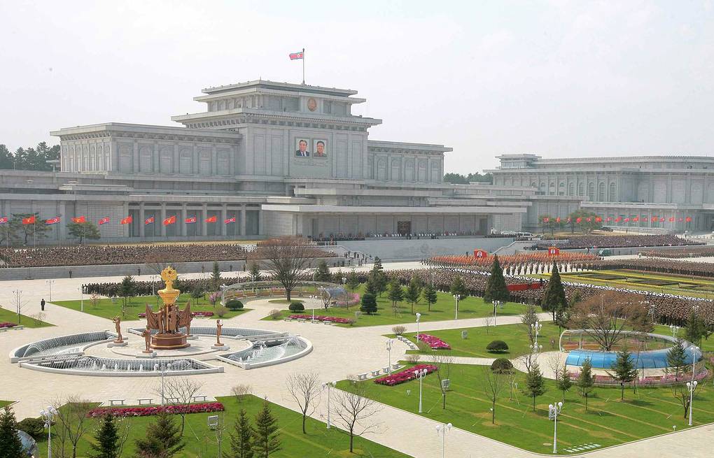
Mausoleum of Kim Il Sung (Kumsusan Palace of the Sun)
https://tass.ru/obschestvo/1803518
The tomb of Kim Il Sung and Kim Jong Il is located in the northeast of the capital Pyongyang in the former residence of the President of the DPRK. In 2012, the mausoleum of Kim Il Sung was renamed the Kumsusan Palace of the Sun. This is the largest mausoleum of the 5 mausoleums in the world, which is dedicated to the communist leader of the country.
The palace with an area of 10.7 thousand square meters was built in 1976 and is made in the style of brutalism. The Kumsusan memorial complex is the holy of holies for every resident of the DPRK. Next to the large marble-pillared hall, which houses the embalmed bodies of two former North Korean leaders, are:
- hall dedicated to the awards of Comrade Kim Il Sung;
- hall dedicated to the awards of comrade Kim Jong Il;
- the Hall of Tears: the most “solemn” and pompous hall, where the nation said goodbye to its leaders;
- halls with exhibits of personal vehicles, outfits, jewelry and gifts from all over the world;
- an exposition with a carriage in which the great leader of the North Korean people died.
Some of the halls inside the building are up to 1 km long.
The wide foyer has been reconstructed into a large park with fountains, flower beds and avenues for visitors.
For foreign guests, the palace can only be visited during an official government tour. Photography, video recording, smoking and talking are prohibited throughout the territory. Palace Square is open.
Opposite the huge building on Mount Taesong is another revered place: the cemetery of revolutionaries, where the closest relatives of the Korean leaders are buried.
Location: Pyongyang, Democratic People's Republic of Korea (North Korea)
Coordinates: 39°03′51″N, 125°47′15″E
Mount Paektusan

https://www.leosimpson.com
Mount Paektusan (white-headed mountain) is the highest point of the Korean Peninsula. It’s height is 2744 m. It is a potentially active volcano, the last eruption of which occurred in 1903.
The volcano is located near the Chinese border. In 1979, Korea's largest nature reserve merged with the Chinese nature reserve to form a single international biosphere reserve around Paektusan.
Scientists date the crater of the volcano to 946, when the very first eruption occurred (7 points). In addition, the volcano showed its activity four more times: in 1597, 1668, 1702 and 1903. The circus-shaped hollow (caldera) is surrounded by 16 peaks with a height of over 2500 m. And on the top of the mountain, right in the crater, there is Lake Chongji or Heavenly (area 9.82 km², depth up to 384 m), which is the object of protection of the National Union for Conservation of Nature of the DPRK and a natural monument. The lake with the purest clear water is also listed in the Guinness Book of Records as the highest alpine crater lake (height 2189 m). To go down to the lake from the observation deck at the top today, it is necessary to overcome 2,160 steps.
The highest and most beautiful mountain on the Korean Peninsula is sacred to the locals and is mentioned in the texts of the hymns of the DPRK and the Republic of Korea. It is here that since ancient times people have collected the root of wild ginseng, known to the whole world for its medicinal properties.
The average annual temperature at the summit is about -8.3 ° C (up to + 18 ° C in summer and up to -48 ° C in winter). The summit has been covered with snow for almost 8 months.
Location: 42 km from Hyesan (Ryanggang), Democratic People's Republic of Korea (North Korea)
Coordinates: 41°59′34″N, 128°04′38″E
Tomb of kongming-wang
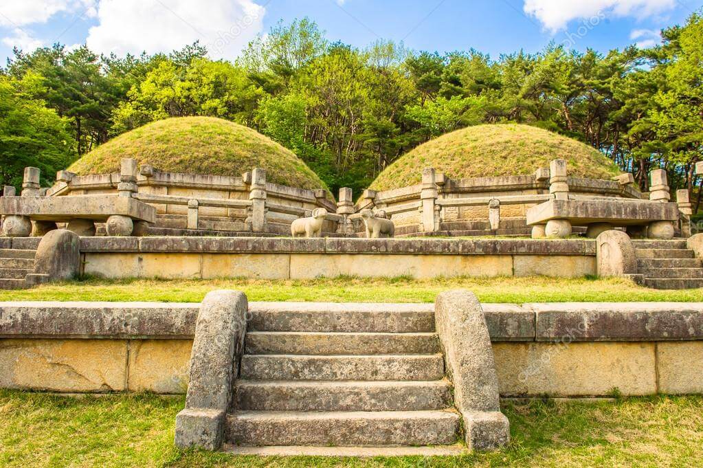
https://artzakaz.pro/foto_posteri/16925545 – grobnica – korolya – kongmin
14 km from Kaesong city in Gaphun county, Hwanghae-Buk-do province, there is a well-preserved tomb of Gongmin-wang. The burial complex was erected in the XIV century on the burial place of Konmin: the ruler (wang) of the Korean state of Koryo.
The paired tomb consists of two burial mounds (about 6.5 m high) on granite foundations, decorated with superbly executed carvings. Numerous stone sculptures of animals (rams and tigers) are located around the mounds. Both crypts are located at the top of a hill, to which you need to climb a stone staircase in four flights. Konmin is buried in one of the crypts, in another - his wife Noguk, who died during childbirth. There are stone sacrificial tables in front of the tombs. Inside the burial mounds there are chambers, the walls of which are covered with frescoes depicting animals, the constellation Ursa Major (Chilson, Seven Stars) and the Sun.
Along the stairs leading to the graves, there are 3-meter statues: four figures of soldiers and officials on each side. Stone lamps are located in front of each flight of stairs.
The burial complex is included in the UNESCO World Heritage List and the list of National Treasures of the DPRK.
Location: Hesolli village, Kaesong, North Hwanghae Province, Democratic People's Republic of Korea (North Korea)
Coordinates: 37°58′48″N, 126°28′12″E
Pyongyang Central Zoo
https://red – sovet.su/post/29932/walk – around – the – north – korean – network
The Central Zoo was opened in 1959 and immediately gained popularity among both local residents and guests of the city. The zoo is located on the outskirts of the capital Pyongyang at the foot of Mount Daesong. A wide variety of flora and fauna are collected in an area of about 3 km². Today the zoo contains 5 thousand animals of 650 different biological species: some of them are representatives of the local fauna, some were brought from other countries. Some animals are gifts from foreign leaders, which can be found on the sign on the aviary.
In zoo:
- 40 enclosures and corrals: elephants, bears, roe deer, monkeys, tigers, lions, giraffes, camels and many others;
- a special enclosure for cats and dogs that are not considered pets in the DPRK;
- the circus;
- large aquarium;
The Museum of Natural History has been built on the territory of the zoo, which is part of the New Pyongyang project and performs a scientific and educational function. A 4-storey building with annexes was built for the museum. The purpose of the museum is to acquaint zoo visitors with the structure of the universe. Therefore, the museum is of no less interest to guests than the zoo itself. Thematic sections of the museum:
- space,
- structure of the Earth,
- climatic zones,
- habitats of animals,
- historical epochs of the Earth,
- a hall dedicated to state symbols.
The Pyongyang Central Zoo is adjacent to the Revolutionary Memorial Cemetery, the Central Botanical Garden, an amusement park, and the Gwangbok Buddhist Temple.
Location:Taesоng District, Pyongyang, Democratic People's Republic of Korea (North Korea)
Coordinates: 39°04′30″N, 125°48′54″E
Major airports in North Korea
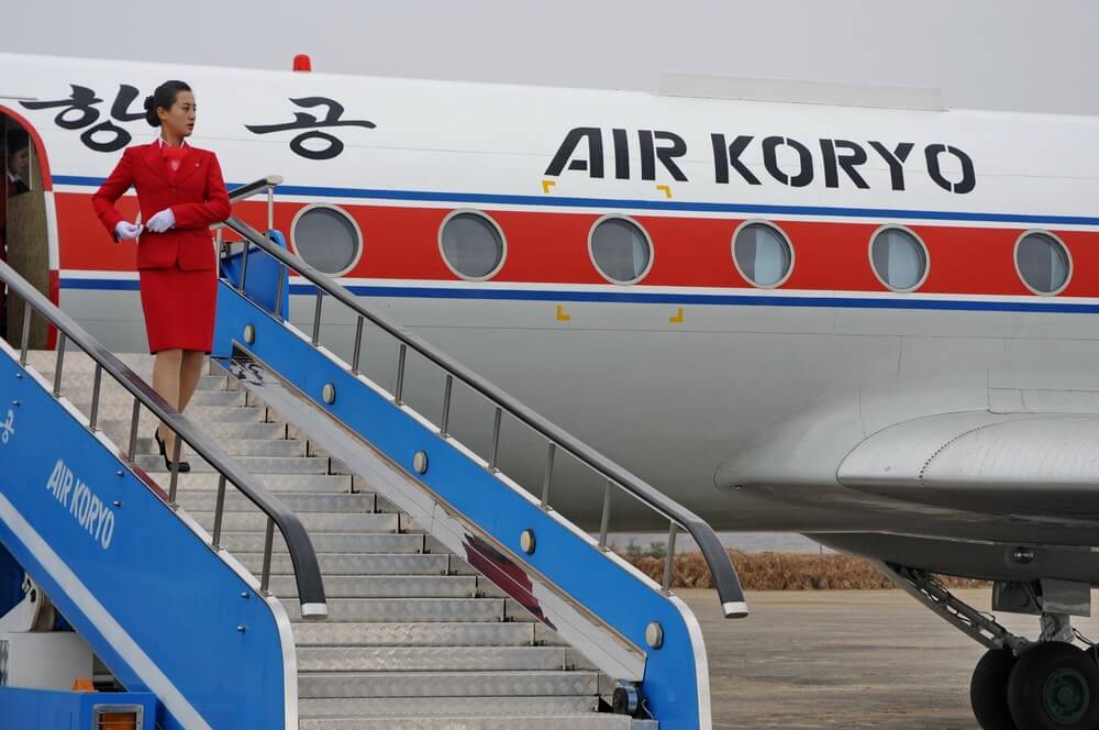
https://itravel.livejournal.com/82657.html
Freedom of movement in North Korea is limited: movement in the country can only be carried out under control, and leaving the country only with permission. International air communications in the DPRK are limited. The national airline is Air Koryo. It serves international, domestic and charter flights. There are 82 operating airfields in the camp, only 39 of them are equipped with hard surface runways.
|
|
|
|
|
|
|
|
|
|
|
|
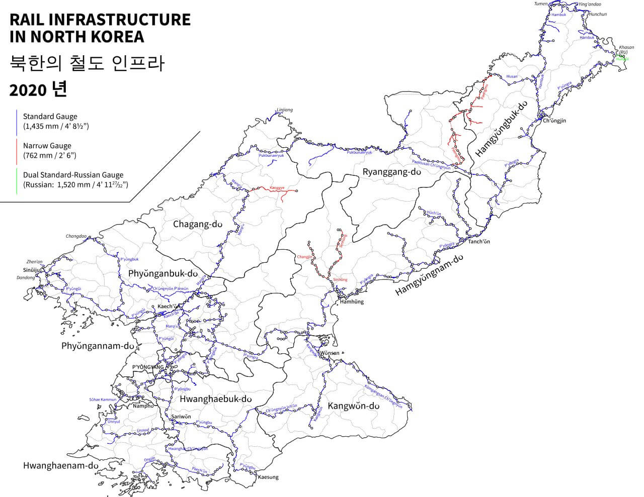
Major train stations in North Korea
North Korea has the only railway operator, the Korean State Railways. The railway track in the country has a length of more than 6 thousand km of wide European gauge (almost all electrified) and 400 km of narrow gauge. Passenger traffic accounts for about 60%. There are no high-speed roads. In 2018, North and South Korea held a symbolic rail unification ceremony. But the level of the DPRK's railway network does not yet reach the level of the South Korean one.
https://twitter.com/KoreDostluk/status/1265578325608710148
Pyongyang Central Station
The central metropolitan railway station has 3 platforms and 6 tracks. Trains from Moscow arrive at this station, having overcome the longest railway track in the world.
Location: Pyongyang, Democratic People's Republic of Korea (North Korea)
Coordinates: 39°00′17″N, 125°44′11″E
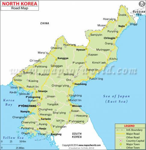
Highways of North Korea
Road transport in North Korea is of secondary importance. This is due to the fact that residents have practically no personal transport and there are restrictions on the amount of fuel. The entire road network in the DPRK is slightly more than 31 thousand km, of which the length of paved roads is only about 2 thousand km. Right-hand traffic. Most people in the DPRK use bicycles as personal transport, so there are very few cars on the roads. Only very wealthy people have personal cars. Traffic lights are only in the capital, therefore traffic controllers control traffic.
There are three main multi-lane highways in the country:
- the Pyongyang-Wonsan expressway (length 200 km);
- the Cheonnyeon-Yeongin highway connecting the capital with the port of Nampo (length 43 km);
- 4-lane Pyongyang-Kaesong highway (length 100 km).
http://holidaymapq.com/north – korea – map/
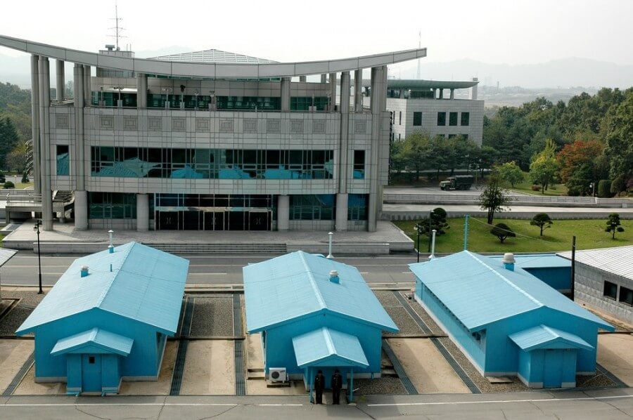
Editor's Choice: Korean Demilitarized Zone
https://itravel.livejournal.com/photo/album/509/
A demilitarized border zone is a territory in which prohibited:
- the formation of the armed forces;
- performing maneuvers;
- construction of military installations, fortifications and other facilities
- and other.
The entire history of a divided Korea is a history of armed clashes. Nevertheless, in the summer of 1953, representatives of North and South Korea came to the signing of an armistice agreement, which ended the Korean War. The agreement established a demilitarized zone and conditions for the return of prisoners of war. But by 2013, relations between the states deteriorated again, and in March 2013, the DPRK announced its withdrawal from the ceasefire.
The demilitarized zone, 4 km wide, stretches for 241 km along the 38th parallel and divides the Korean Peninsula into two parts, into two different worlds. In the middle of the zone there is a ceasefire line (military demarcation line), which is marked along its entire length by identical signs (1292 signs). Not far from Panmunjom (the most accessible place for tourists) there are strictly guarded and one-of-a-kind rail and road crossings across the border between the two sides.
It is possible to visit the demilitarized border zone from both the northern and southern sides, but under strict control and strict rules. In North Korea, an excursion to the DMZ is conducted by an officer of the North Korean army. The excursion program includes:
- visiting the building where the agreement was signed;
- the monument with the last autograph of Kim Il Sung;
- a house for negotiations;
- the observation balcony of the House of Liberty, from where you can look at the South Korean side through binoculars.
In some places of the border, observation points have been organized, where you can see a panorama of the demilitarized zone and border territories of South Korea.
Coordinates: 38°18′N, 127°16′E