Norway map
https://www.makalius.lt/
Norway is a country of contrasts. The country is located in Northern Europe, in the west and northwest of the Scandinavian Peninsula. It is washed by the seas of the Atlantic and Arctic Oceans. Norwegian Overseas Territories: Bouvet Island in the South Atlantic Ocean. Norway also claims Peter I Island and Queen Maud Land in Antarctica, which fall under the 1961 convention. King - Harald V, Prime Minister - Jonas Gahr Støre. The total area of the continental part of Norway is 323,786 km², and including the Svalbard archipelago and Jan Mayen Island - 385,207 km².
Oslo is the capital of Norway and the place of residence.
Norway is a unitary state with a constitutional monarchy.
Norway is a member of NATO, the Scandinavian Passport Union and the Schengen Area, and has topped the list of countries in the Human Development Index since 2009.
The climate of Norway is temperate oceanic, in the north of the country it is subarctic, in the Svalbard archipelago it is arctic. The average annual temperature in Oslo is +6 °С, in Varda +1 °С, in Longyearbyen (Spitsbergen archipelago) -6 °С. The climate is significantly influenced by the warm current of the Gulf Stream.
Timezone: UTC+1:00 Coordinates: 61°0′0″N, 8°0′0″E
Regions of Norway
Norway is subdivided into 11 counties (counties, regions or provinces), which in turn are divided into 356 municipalities.
The counties are grouped into 5 main unofficial regions:
Nord-Norge (Northern Norway). Area 112,951 km², population 482,000 people, density 4.3 people/km².
Trøndelag (Central Norway). Area 42,201.59 km², population 471,124 people, density 11 people/km².
Vestlandet (Western Norway) - Area 58,582 km², population 1,456,900, density 25/km².
Østlande (Eastern Norway) - Area 94,577 km², population 2,700,000, density 29/km².
Sørland (Southern Norway) - Area 16.434 km², population 277.250, density 17/km².
The most interesting sights of Norway
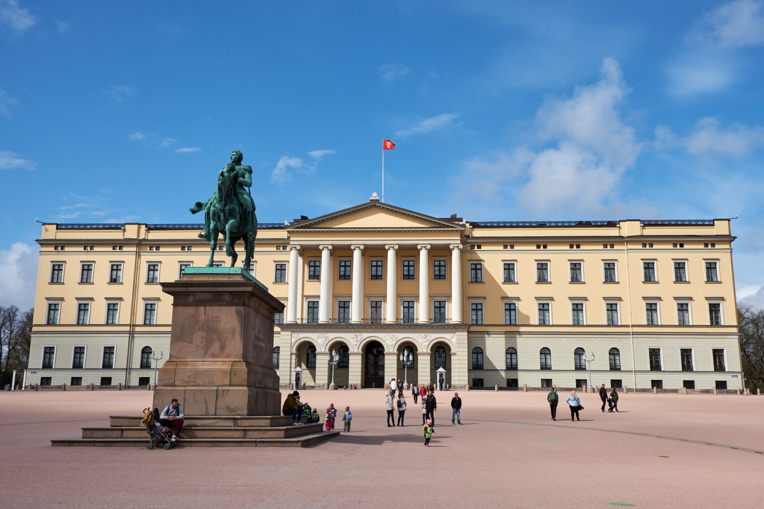
Royal Palace in Oslo
https://traveltimes.ru
The Royal Palace in Oslo is the majestic residence of the Norwegian monarchs. The building of the palace was built in the first half of the 19th century in the neoclassical style. In front of it is a statue of King Karl Johan XIV. Guided tours and exhibitions are held in the summer. Surrounded by a royal square and a royal park of 22 hectares, open to the public.
Location: Oslo, Norway Coordinates: 59°55′0.88″N, 10°43′39.24″E
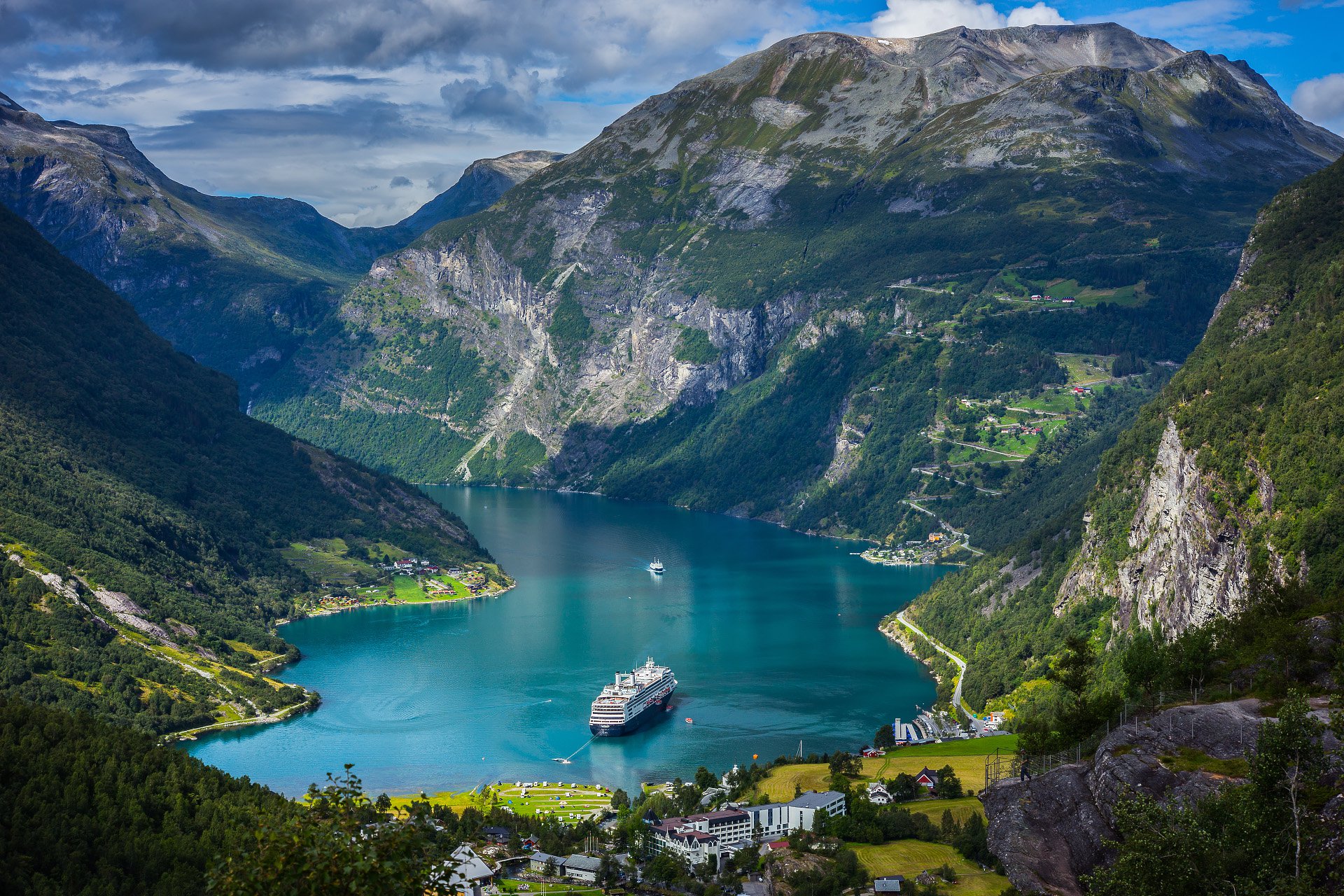
Geirangerfjord
https://nat-geo.ru
The Geirangerfjord is a picturesque fjord in the Sunnmøre region, southernmost part of Møre og Romsdal county in Norway. It is located 200 kilometers northeast of Bergen and 280 kilometers northwest of Oslo. The 15 km long fjord is one of the offshoots of the Storfjord. Depth is 565 meters. It was inscribed on the UNESCO World Heritage List in 2005.
Near the Geiranger Fjord is the village that gave it its name - Geiranger. In the village there is a fjord museum that tells about the natural history of this region of Norway.
The fjord is famous for its waterfalls, the most famous of which are: the Seven Sisters, the Bridal Veil and the Groom. Along the banks there are sheer cliffs up to 1400 meters high and glaciers. Along the Geirangerfjord, there are abandoned farms, some of which are located on small areas of mountain ledges. To get to them is possible only by special or rope ladders.
Location: Sunnmøre, Møre og Romsdal, Norway
Coordinates: 62°7′15.6″N, 7°7′44.4″E
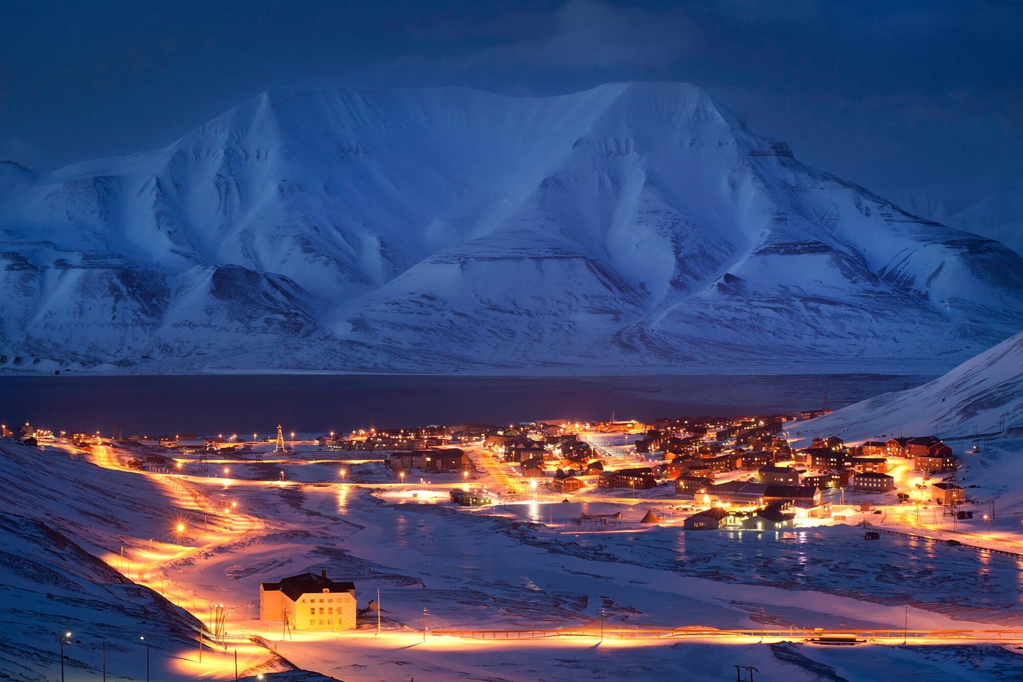
Svalbard Archipelago
https://monsoondiaries.com/
Svalbard is a vast polar archipelago, the northernmost part of Norway. Located in the Arctic Ocean. The climate is subarctic. The administrative center is the city of Longyearbyen. The archipelago and coastal waters are a demilitarized zone.
In addition to Norway significant economic activity in the archipelago is carried out only by Russia, which has a Russian settlement on the island of Western Spitsbergen: the village of Barentsburg, as well as the mothballed villages of Piramida and Grumant.
Large deposits of high-calorific coal (10 billion tons). Svalbard is also unique in a significant number of rocks with fossil remains of plants and animals. In 2007, a Norwegian team of paleontologists managed to discover the remains of the largest pliosaurus Pliosaurus funkei in the archipelago. The high diversity of geological rocks of the archipelago is explained by its long migration through the Earth's mantle, during which Svalbard visited different climatic zones.
The archipelago is located in a seismically active zone, earthquakes with a magnitude of 4 - 5 points on the Richter scale were noted.
About half of the territory is occupied by nature protection zones: 3 reserves and 3 sanctuaries.
A unique feature of Svalbard is the extremely low content of microbes, dust and parasites in the air and soil. The low biological activity of the environment ensures the high safety of both organic matter and artificial objects and structures. Even after being abandoned for decades, some buildings in Svalbard can look like people left them only yesterday. For the same reason, there is currently no cemetery in Svalbard and no burials are held.
Seven national parks have been created on the territory of the archipelago, and many animals (including deer, beluga whales and arctic foxes) can often be found right in Longyearbyen or near the airport. Also, the hallmark of Svalbard are aggressive terns that defend their territory by diving on passers-by. Polar bears and walruses are much more difficult to see: in summer they are in the northern part of the archipelago, and in winter they migrate south.
Location: Norway
Coordinates: 78°13′12″N, 15°39′0″E
Bryggen
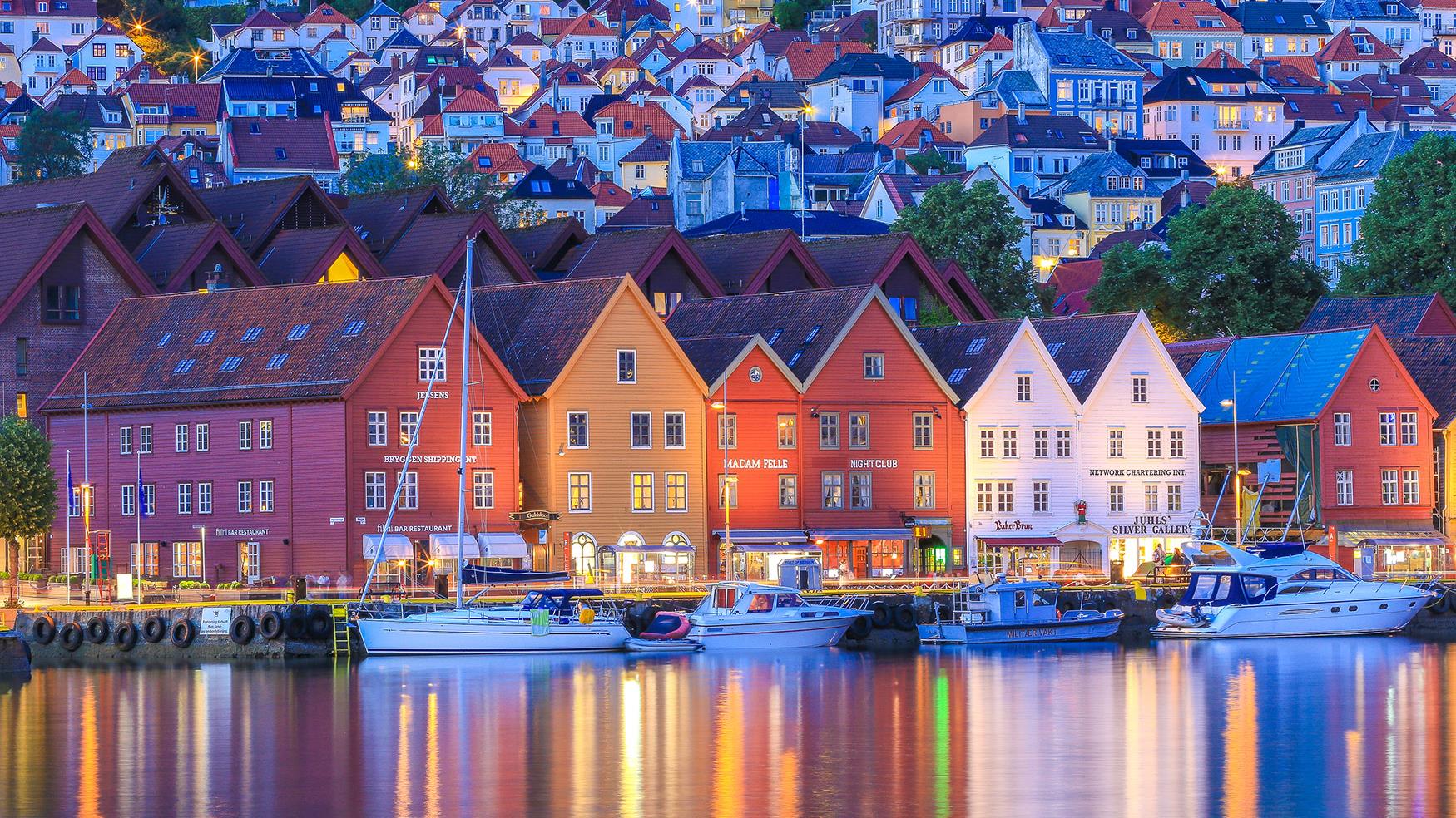
https://geografishka.ru
Bryggen is a popular complex of commercial buildings located on the waterfront in the center of Bergen. Listed as a UNESCO World Heritage Site in 1979.
The city of Bergen was founded in 1070. In 1360, a representative office of the Hanseatic League was established in Bergen and the city became an important trading center. The administrative buildings housed clerks from many European countries, mainly from Germany. Warehouses were filled with goods such as fish from Northern Norway, as well as grain from Europe.
Traditionally, most houses are made of wood, which is why throughout history, Bergen has been subjected to numerous fires. At the moment, about a quarter of Bryggen's buildings were built before 1702, while older warehouses and administrative buildings burned down. The rest of Bryggen mostly consists of younger buildings but there are stone cellars that date back to the 15th century.
Also, part of the buildings was destroyed during a fire in 1955. Later, this area was used to build the Bryggen Museum, which consists of a complex of archaeological sites as well as some old wooden houses. Today, the buildings of Bryggen house many tourist and souvenir shops as well as restaurants, cafes and museums.
Location: Bryggen, 5003 Bergen, Norway
Coordinates: 60°23′50″N, 5°19′23″E
Håkon’s Hall and The Rosenkrantz Tower
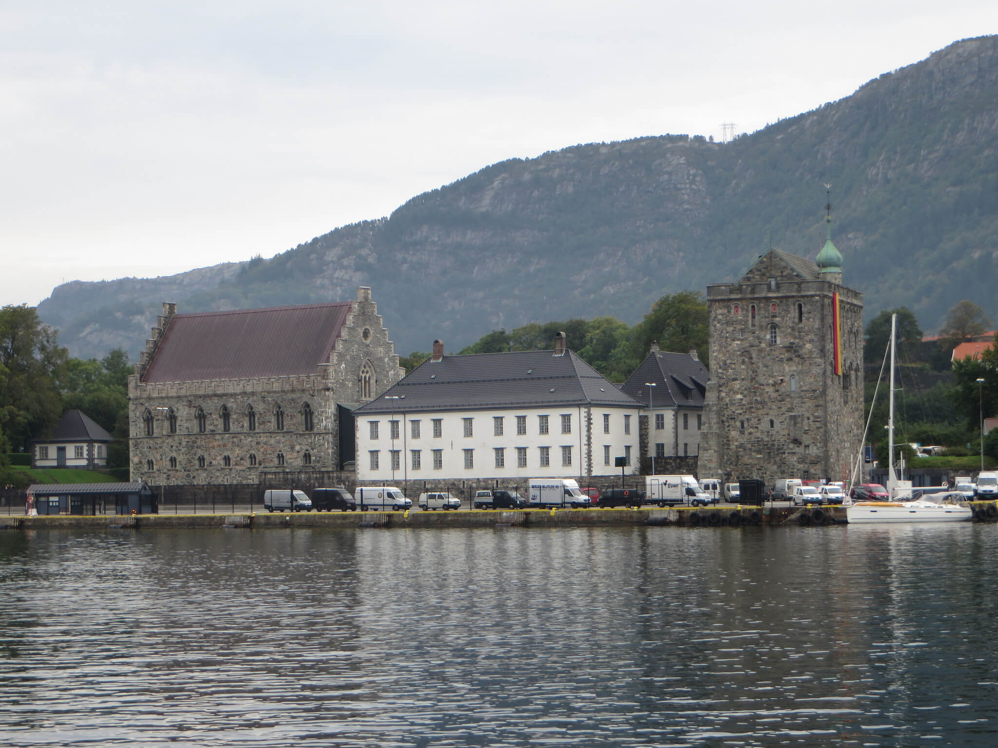
https://tonkosti.ru
This 750 year old castle was built by King Haakon Haakonsson as his own residence with a particularly impressive banquet hall. When Magnus Haakonsson Lagabot (the royal offspring) married the Danish princess Ingeborg in 1261, two thousand guests were invited to the feast. ‘The king judged in a stone hall’, the words of an ancient saga say. At this time, Bergen was the largest and most important city in the whole country, and Haakon's Hall was the venue for major national events; in particular, the announcement of the first complete Norwegian Code of Laws.
When Norway united with the rest of the Scandinavian countries, the importance of the castle began to decline. There was even a granary here. It was decided to restore the former glory of the hall only in the second half of the 19th century. As a national monument, Haakons Hall is still occasionally used for official ceremonies. It is visited, in particular, by the king himself.
The Haakon Hall is closed during the Bergen International Festival, at Christmas, Easter and on special occasions as well as on public holidays on 1 and 17 May. The on-site cafe is open during the summer season from June to August.
On the territory of the fortress is the Rosenkranz Tower: a defensive structure of a later period. It was erected in 1560 by order of Rosencrantz, governor of Bergenhus. The tower was rebuilt and expanded over time, and guns were installed on its roof. Today it is considered one of the most important monuments of the Norwegian Renaissance.
Location: Bergen, Norway
Coordinates: 60°24′2.11″N, 5°19′3.66″E
Vöringsfossen
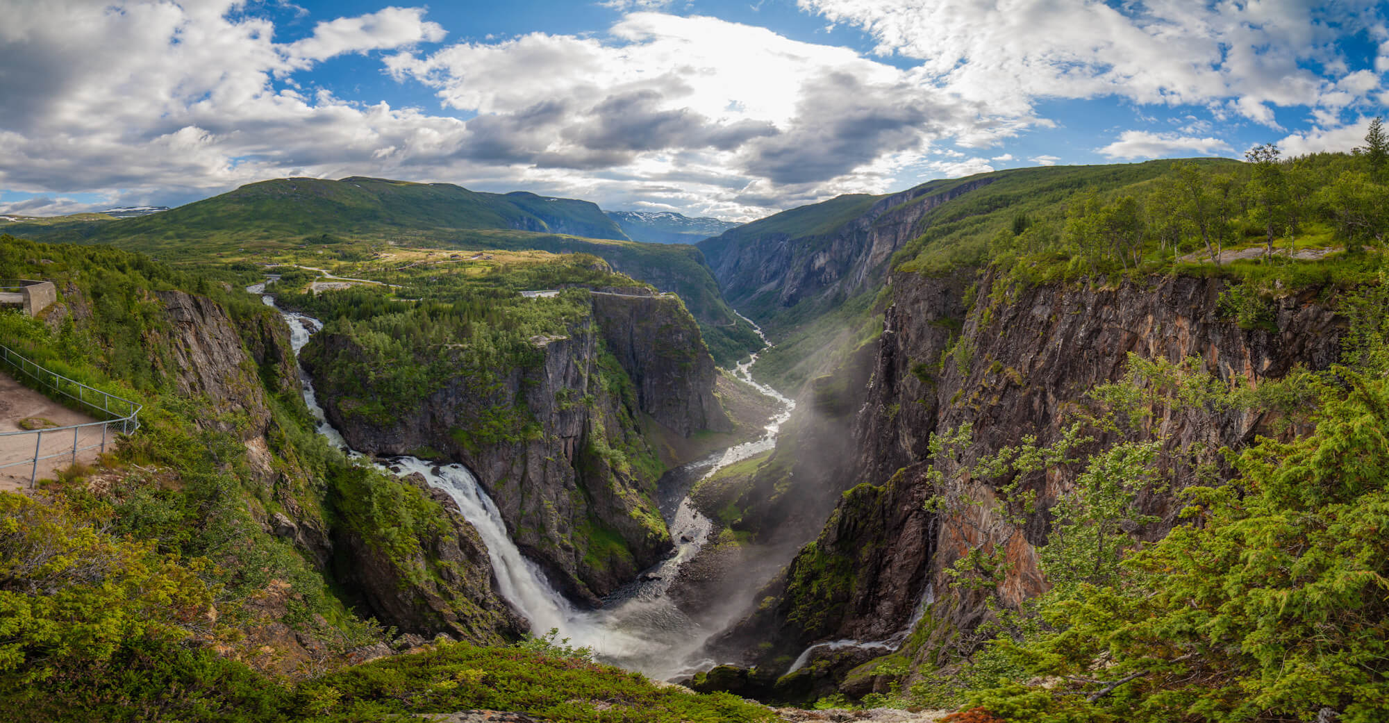
http://windoftravel.net
Vøringsfossen is the 83rd tallest waterfall in Norway based on total falls. Located in the upper part of the Mobødalen valley in the municipality of Eidfjord, in the county of Westland. Its total height is 182 meters, the main one is 163 meters. One of the most famous in the country and the main tourist attraction on the way from Hardangervidda to the Hardangerfjord.
There are several warning signs of the relative danger of falling to your death. In the spring of 2015, other measures to prevent deaths were implemented, in 2020 a stair bridge was opened.
Until 1821, the waterfall was almost unknown to anyone except the locals. In the same year, Professor Christopher Hansten, who was on his way to the Hardangervidda Plateau to make astronomical observations, estimated the height of the waterfall at about 280 meters by throwing stones from the edge and measuring the time of their fall with a pocket watch. In 1893, it was measured with a rope, the real height was 163 meters.
In 1880, Ola Garen decided to build a hotel on top of the falls. The only way up was the 1,500-step trail up Mobøbjerget, along with a bridle trail built in 1872 to take English tourists to the falls. In 1891, a new road with tunnels was laid along Eidfjordvandet, and in the same year the Fossli Hotel, designed in Art Nouveau style by architect Frederik Konow Lund, was completed. All building materials had to be transported on horseback from Eidfjord to the top of the hill.
There is good infrastructure, parking, toilets, souvenir shops, and a restaurant. Benches, bridges and handrails have been installed along the cliff. The authorities of the region claim that by 2023 the place will become even more comfortable and safer for tourist groups.
The talented composer Edvard Grieg owned a log cabin nearby and he frequented the falls.
Eidfjord is the closest settlement to Vøringsfossen. From it to the waterfall is another 18 km.
Location: 5785 Eidfjord, Norway Coordinates: 60°25′33.62″N, 7°15′ 3.34″E
Airports in Norway
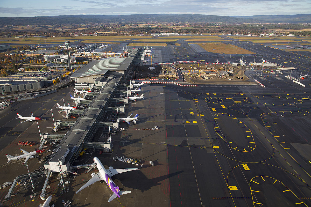
http://upload.turkcewiki.org
Norway has 98 airports. Public flights are served by 48 airports, including one heliport (Verøy Heliport). Forty-five of them are owned by the state through airport operator Avinor.
Airports used only for general aviation (GA) are owned simultaneously by municipalities, aviation clubs and private companies. The latter include those controlled by the state or municipalities. Two of them belong to the Norwegian Armed Forces. The Royal Norwegian Air Force maintains ten airfields, which are located near the main airports (‘shared’ airports).
|
|
|
|
|
|
|
|
|
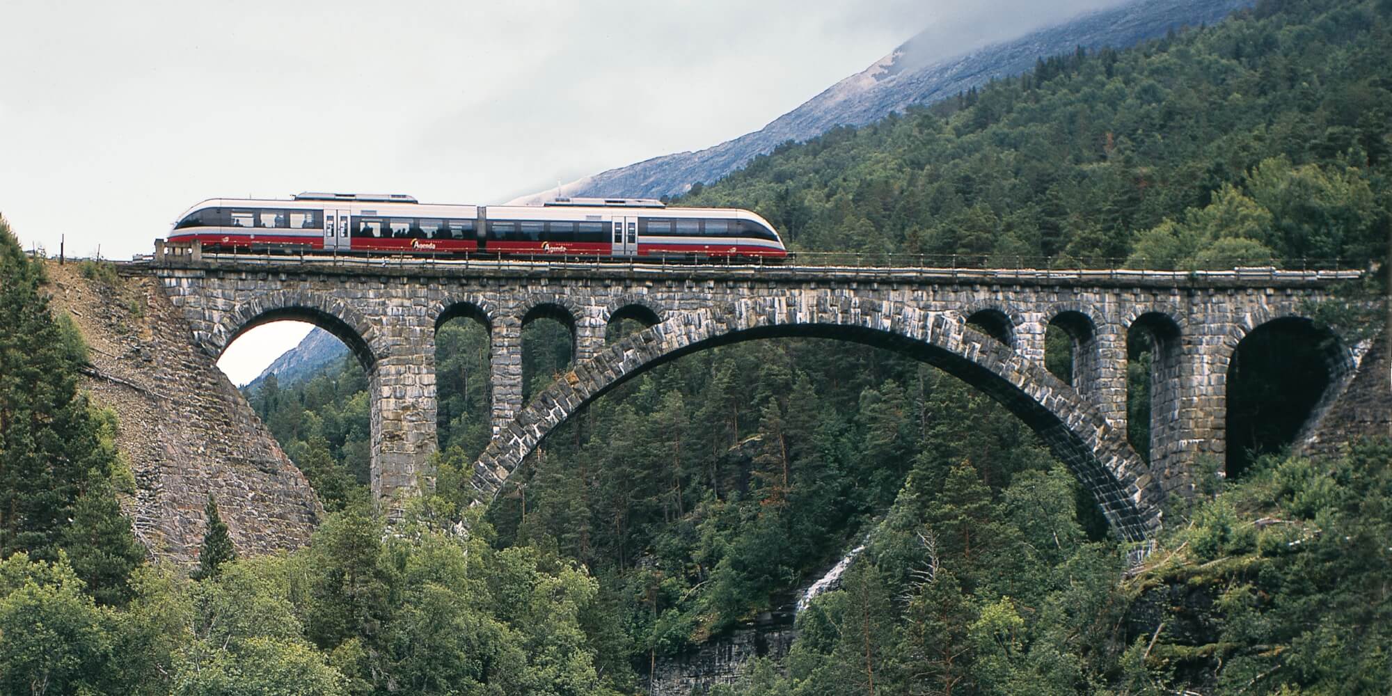
Railways in Norway
https://www.visitnorway.ru
The railway transport of Norway (length 4114 km, including 64 km of high-speed lines) is widely demanded by the population of the country as a reliable means of communication between the scattered regions of Norway. Rail transport is most developed in the western region. The state gives great importance to the development of long-distance intercity transportation by InterCity trains. Railways are expected to play a key role in improving Norway's public transport system.
The Flåm Railway is the most popular railway tourist attraction in the world.
The railways are operated by the state-owned company NSB - Norges Statsbaner.
The railway network of Norway consists of five directions diverging from Oslo: southern Sørlandsbanen (from Oslo to Stavanger), mountainous Bergensbanen (from Oslo to Bergen), central Døvrebanen and Rørosbanen (from Oslo to Trondheim) and northern Nordlandsbanen (Trondheim-Bodø).
|
|
|
|
|
|
|
|
|
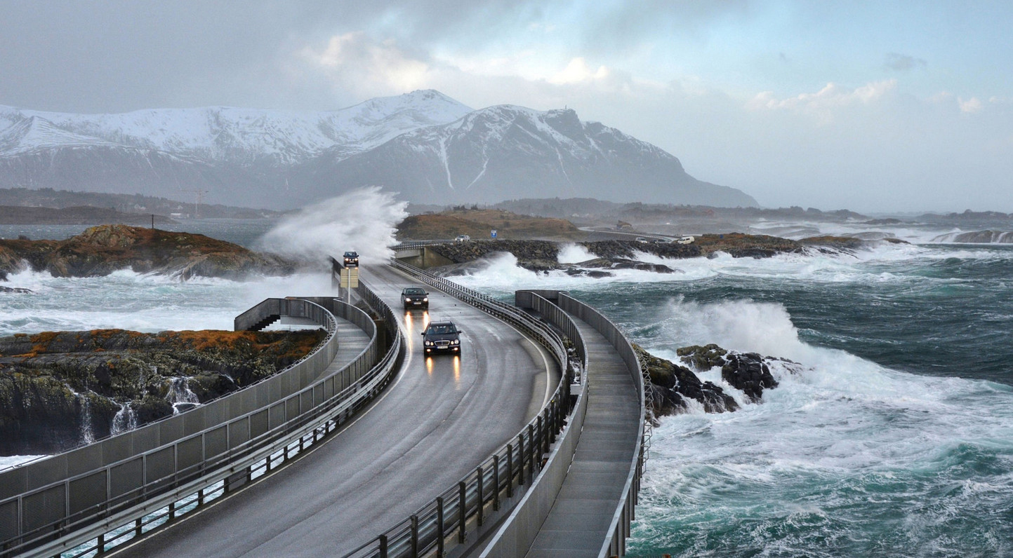
Roadways in Norway
https://rosphoto.com
Norway's public road network is 93,870 km long. Of these, with a hard surface - 75.754 km. The length of highways is 664 km.
There are 45 toll roads in Norway. 25 of them are equipped with electronic barriers.
Entrance to the center of some cities in Norway is paid.
Some roads in Norway are closed in winter. Roads may be closed for various periods, depending on weather conditions.
It is recommended to check the weather forecast before going on a trip to the mountains. For more information, contact the Road Information Service on 175 (+47 815 48 991 from abroad). The service operates 24 hours a day.
Standard speed limits in Norway for cars and motorcycles(unless otherwise indicated on signs):
- inside the settlement - 50 km/h
- outside the settlement - 80 km/h
- on the motorway - 100 km/h
Fines for speeding are among the highest in Europe. There is no allowed speed limit. This means that if you exceeded the speed limit even by 1 km/h, then you may be fined.
The Norwegian Ministry of Roads is one of the Norwegian government ministries responsible for the state of the country's public road network. This ministry is responsible for planning, building, subsidizing and operating the state and county road networks.
The Norwegian state is located in the North of the Scandinavian Peninsula and stretches from the Northeast and Southwest along the coast of the Atlantic Ocean. This area is a mountainous and hilly area on the territory of which the Scandinavian mountains (up to 2500 meters high) stretch.
Because of this, a distinctive feature of the Norwegian roads is a huge number of tunnels built: 1100 pieces. The length of the longest tunnel ‘Laerdal’ is 24.5 km. It is also the longest tunnel in the world, and is part of the Oslo-Bergen highway.
In addition, about 23,000 bridges have been built and are in operation in Norway. Of the most famous: Storsesandetsky bridge with a length of 8.5 km.
Currently, there are 45 toll roads in the country.
The fare depends on the length of the route, the mass of the car, the time of day and starts from 12 kroons (about 110 rubles) for cars and reaches 600 kroons (for road trains on the Hardangerbrua-Hordaland highway).
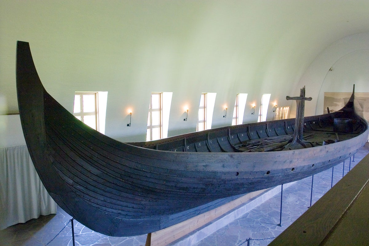
Editor's Choice: Viking Ship Museum
https://www.itinari.com
An educational Viking ship museum located on the Bygdøy peninsula within Oslo. It is part of the Museum of Cultural History at the University of Oslo. Stores archaeological finds from Thune, Gokstad (Sandefjord), Oseberg (Tønsberg) and the Borre mound cemetery.
Since 1926, the famous Viking ships have been exhibited: the Tune ship, the Gokstad ship and the Oseberg boat. All of them are made of oak and were used as funerary ones. They are over 1000 years old. The most famous of them is Gokstad, built around 800 AD. Completely preserved, it is the largest known burial ship. In addition, the exposition of the Viking Age shows sledges, beds, a wagon, wood carvings, parts of a tent, buckets and other items from burials.
A monument to Helge Markus Ingstad stands at the entrance to the museum. In the middle of the 20th century, he managed to find Viking settlements in a small Canadian village. They were created in the X-XI centuries: about 450 years before the official discovery of America by Christopher Columbus.
The museum is small in size, it has only four halls arranged in a cross but they store priceless artifacts from the Viking Age. The Vikings plowed the seas and oceans on such boats.The boat is 22 meters long and 6 meters wide.
Location: Oslo, Norway
Coordinates: 59° 54′ 17.12″ N, 10° 41′ 4.06″ E