RSE map
https://wallpaperscraft.ru/wallpaper/kejptaun_afrika_bereg_lodki_gory_110759
The Republic of South Africa is the former colony of the British Empire. Located in the southern part of Africa and covers an area of more than 1.2 million km². The state is home to 54.9 million people of different nationalities.
The coast of South Africa is washed by the Indian and Atlantic oceans. The coastline with beautiful bays is 2798 km. More than half of the country's territory is located at an altitude of more than 100 m. The highest point is Mount Njesuthi (3410 m), located in the mountains in the state-enclave of Lesotho. The longest river is Orange (length 1860 km) and all the largest rivers of the republic originate in the Drakensberg Mountains.
South Africa presents a variety of climatic zones but the climate is mainly tropical with average temperatures: January + 18 ... + 27 and July + 7 ... + 10. Precipitation indicators vary significantly: on the lowlands and slopes of the Great Ledge from the ocean side 1000-2000 mm, up to 150 mm in the interior regions.
The best time to visit South Africa is spring, although most of the country's national parks are comfortable only in African winters (June-July).
South Africa has a whole national network of territories taken under state protection:
- Kruger National Park,
- Kgalagadi Transfrontier Park,
- nature reserves, etc.
Ukhahlamba-Drakensberg Park, Mapungubwe Cultural Landscape, Isimangaliso Wetland, Richtersfeld Nature Reserve are included in the World Heritage List.
Time zone: UTC + 9.
According to the form of government, South Africa is a parliamentary-presidential (mixed) republic. The city of Pretoria officially bears the status of the capital, since the government of the republic is located here. But there are two more unofficial capitals: Cape Town (Parliament) and Bloemfontein (Supreme Court). This arrangement of the branches of government is due to the fact that until 1910 South Africa was a confederation.
There are 11 official languages in the republic, and this is the first state in the world that voluntarily renounced nuclear weapons.
Among the countries of the African continent, South Africa is the only country that entered the G20.
And, despite the fact that in the country:
- unemployment is over 40%;
- mortality exceeds birth rate;
- low level of education (the penultimate place in the world);
- leadership in the massive spread of HIV;
- one of the highest crime rates in the world,
South Africa is considered the most developed republic in Africa. It is rich in huge reserves of natural resources. The economy is based on the mining industry (52% of exports). Only 1/7 of the entire territory is suitable for agriculture, however, this is enough for complete self-sufficiency. South Africa is a major supplier of agricultural products. Winemaking, animal husbandry, fishing, and tourism are well developed.
The country with the richest natural and cultural heritage annually attracts about 10 million tourists.
Inside the territory of South Africa is the state-enclave of Lesotho.
Coordinates: 29°10′ S, 24°55′ E
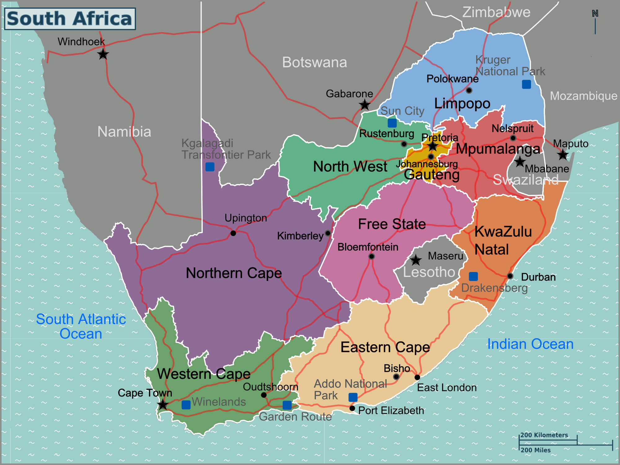
Regions of the country
The unitary state of South Africa has a three-tier administrative division. The territory is divided into:
- Level I. 9 provinces (Eastern Cape, Western Cape, North Cape, Gauteng, Northwest, Free State, Limpopo, KwaZulu-Natal, Mpumalanga):
- North Cape is the largest province (an area of about 373 thousand km ²), occupying ⅓ of the country's territory. At the same time, in terms of population, the province is the last on the list (just over 1.1 million people). The administrative center is the city of Kimberley. Divided into 5 districts. The basis of the economy: mining of diamonds and other minerals, agriculture.
- East Cape is the second largest province in South Africa (about 167 thousand km², population about 6.6 million people). The capital is the city of Bisho. One of the poorest provinces, with a low standard of living and an undeveloped economy. Divided into 2 districts and 6 districts. The backbone of the economy: the automotive industry, agriculture and industrial fishing and squid.
- Gauteng is the most densely populated province and is the smallest of all provinces with an area of 18.1 thousand km². It is a home to about 12.3 million inhabitants. The administrative center is the city of Johannesburg. It is divided into 3 urban districts and 2 districts. An important economic center not only of the country, but of the entire continent.
- KwaZulu-Natal is a province with the second largest population (about 10.3 million people, an area of 94.3 thousand km ²). The capital is the city of Pietermaritzburg. The main economic center and large port is the city of Durban (sugar cane processing, oil refining, light industry, rubber production).
- Limpopo is one of the poorest provinces (area 76.5 thousand km², population over 4 million people). The administrative center is Polokwane. Important highways to major ports and the busiest highway in South Africa, highway number 1, pass through the province.
- Level II. 52 districts (44 districts and 8 urban districts);
- Level III. 226 local municipalities.
https://www.maps-of-the-world.ru/africa/republic-of-south-africa/large-regions-map-of-south-africa
The most interesting sights of South Africa
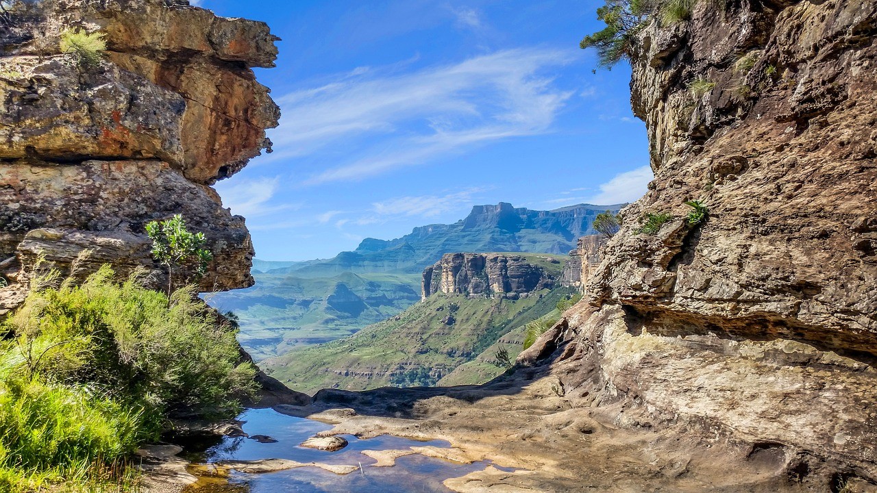
Drakensberg mountains. Drakensberg Park
https://travelurway.ru/prekrasnaya-i-opasnaya-priroda-afriki-yuar/
Drakensberg Mountains is a natural wonder about 360 million years old. Located in the southern part of the African continent. The mountain range covers an area of about 402 thousand km ² and is the highest in South Africa. Most of the mountain system is part of the huge Drakensberg Park, which is protected by UNESCO.
The Drakensberg Mountains are famous for their green slopes. Despite the hot climate and proximity to the Indian Ocean, the mountain peaks in winter wear snow caps and contrast with the vibrant green at the foot of the mountains. And only here you can see the pristine beauty of nature, untouched by civilization.
The flora and fauna rich in species are distinguished by a large number of endemics.
In addition to natural resources, the Drakensberg Park will find something to surprise the most discerning travelers. The reserve provides tourists with unique opportunities for hiking, horse riding, and fishing. Golfing in one of the most scenic spots in South Africa.
In the small town of Bulwer, a unique church was built from a yellow tree that grows only in South Africa. And lovers of archeology will appreciate the caves with ancient rock paintings, the total number of which is about 40 thousand. The Giant's Castle reserve, in which the largest number of rock art objects. It is listed in the book World Heritage.
One of the most popular tourist destinations is visited by more than 2 million people a year.
Location: Ukhahlamba Drakensberg, Mkhomazi Wilderness area, KwaZulu-Natal, South Africa
Coordinates: 27°26′00″S, 29°55′00″E
Cape of Good Hope. Cape Town
https://z1v.ru/mys-dobroy-nadezhdy-fotoistoriya-o-stolknovenii-dvuh-okeanov/
The Cape of Good Hope is the most extreme southwestern point of the African continent and is located on the Cape Peninsula 50 km south of Cape Town. This is the most famous cape of the African continent, the name of which serves as a reminder of the era of great geographical discoveries. Its discoverer is Bartolomeu Dias who first saw this picturesque point of the globe on February 3, 1488. The Cape of Good Hope is one of the tallest coastal cliffs in the world with an absolute height of 250 meters.
The Table Mountain National Park is a natural landmark where two oceans meet: the cold Atlantic and the warm Indian. Public transport does not go here so you can get here by taxi, rented car or with a guided tour.
The main attraction in the vicinity of the Cape of Good Hope is the lighthouse at Keith Point (2 km to the southeast). Built in 1860, it became the most powerful lighthouse in the world: 80 thousand candles illuminated a distance of up to 80 m.Today, it serves as a museum and an observation deck from which a stunning view of the Cape of Good Hope opens.
Location: Cape Point Rd, Cape Town, South Africa
Coordinates: 34°21′33″S, 18°28′21″E
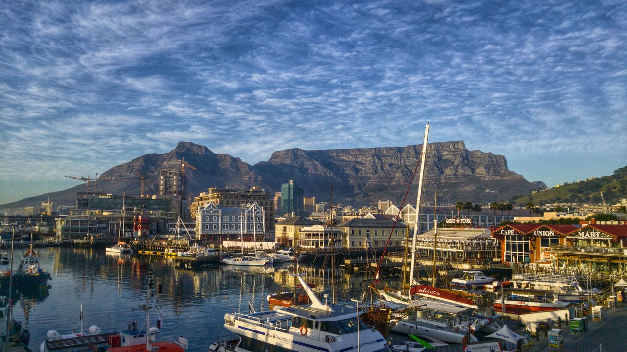
Cape Town
https://makddu.ru/477-yuar-v.php
Cape Town has the second largest population (3.7 million people) and is located in the southeast of South Africa. It is the most visited city in South Africa. Cape Town deservedly bears the status of the cultural capital of South Africa because unique attractions are collected on its territory:
- The symbol of the city and the main attraction is Table Mountain, which rises 1087 meters above sea level and serves as a magnificent observation deck, thanks to its flat top.
- The Two Oceans Aquarium. The largest aquarium in the Southern Hemisphere (11 meters high), featuring 300 species of the inhabitants of the two oceans.
- The largest museum in South Africa. South African National Gallery.
- Botanical Garden Kirstenbosch (area 528 hectares) is one of the seven best botanical gardens in the world.
- The largest entertainment and shopping center Victoria, Alfred Embankment.
- The Castle of Good Hope. The oldest surviving building in South Africa, which houses a military museum with a rich collection of weapons and ammunition.
- Diamond Museum and more.
Location: South Africa
Coordinates: 33°55′S, 18°29E
Sun City Resort
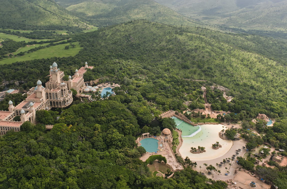
https://wetu.com/iBrochure/sv/Information/2253-68/sun_city_cabanas_hotel/Activities
The unique modern hotel and entertainment complex Sun City was built in 1979 in the Northwestern province of South Africa, near the city of Rustenburg. Here, natural beauty and the creations of human hands are harmoniously combined.
Sun City is one of the best entertainment complexes in the world. Its territory covers about 150 km²:
- many hotels from 3 to 5 stars (Sun-City Hotel, Cabanas Hotel, The Cascades Hotel, The Palace of the Lost City, one of the world's leading hotels, etc.);
- park Lost City;
- the world's largest water park: Valley of the Waves, which includes:
- an artificial lagoon with imitation of ocean waves for surfing,
- the world's tallest artificial waterfall,
- Temple of Courage. Descent along a 70-meter toboggan (17 m of free fall),
- quartz sand beach,
- aquapark;
- tropical gardens with unique collections of flora and fauna;
- Segaetsho village: traditional African dances, music, crafts;
- Africa's largest casino and nightclubs;
- restaurants;
- game centers;
- a concert hall for 6 thousand seats;
- 2 international standard golf courses (18 holes) and a 5 km jogging track;
- attractions;
- Labyrinth of the Lost City (a maze made of artificial stone and wood, which is the largest in the southern hemisphere);
- interactive museum South African Hall of Fame (the most famous people of South Africa and their achievements).
Sun City is bordered by the Pilanesberg National Park, which is home to a huge number of African animals.
Sun City is rightfully considered the best resort in South Africa by сombining such a wide range of entertainment, making the complex accessible to tourists with different income levels.
Location: Sun City Resort off the R556, North West Province, Sun City 0316, South Africa
Coordinates: 25°20′25″S, 27°5′27″E
Limpopo Transboundary Park. Kruger National Park
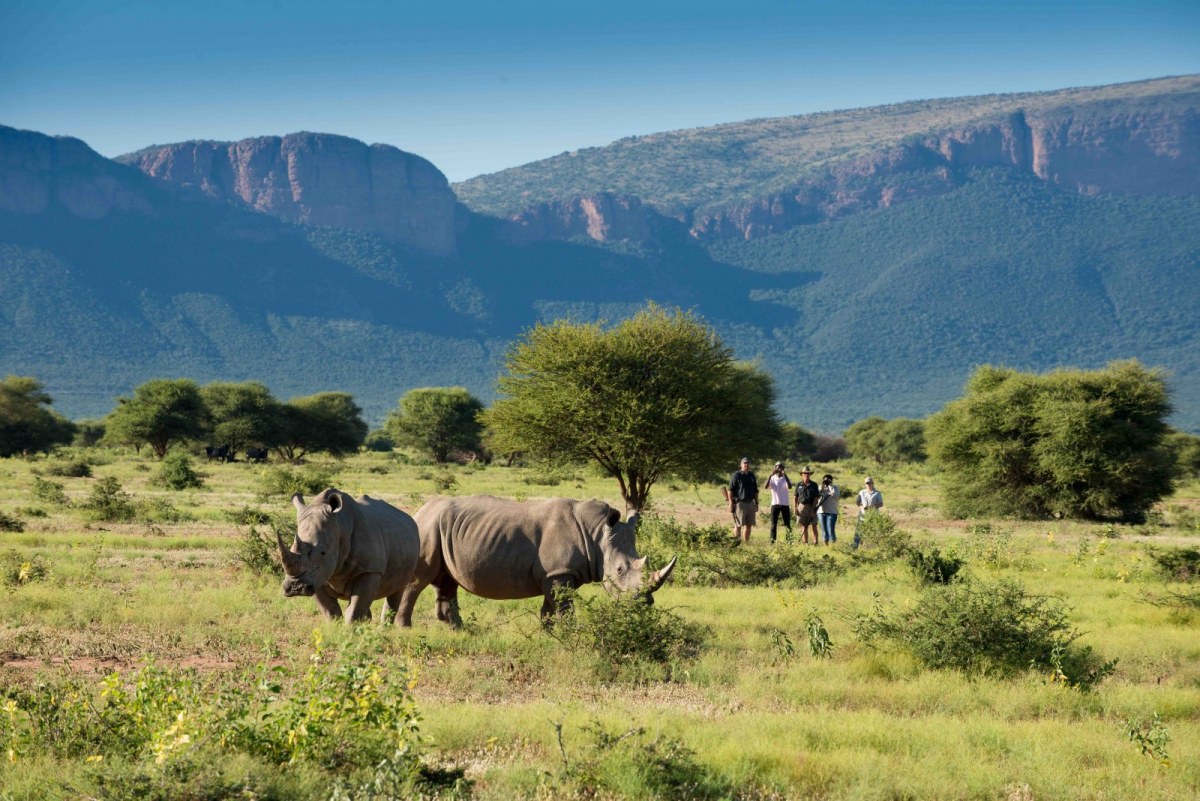
https://www.terraficionados.com/blog/2019/08/19/unique-unforgettable-experiences-in-south-africa
Limpopo is the world's largest protected transboundary reserve. It was opened in April 2002. This unique park has no analogues in the world. Its area is about 4 million hectares and includes both private and state territories of three states: South Africa, Mozambique and Zimbabwe. In total, the Limpopo Park has about 50 reserves on its territory. These include the Kruger National Park, located in northeastern South Africa and occupying two provinces (Limpopo and Mpumalanga). It is South Africa's oldest national park and is part of the Kruger-to-Canyons Biosphere Reserve, established in 2001. The length of the safari park from north to south is 350 km, the area is 19 thousand km ².
The park attracts with picturesque views, unique nature, richness of flora and fauna, and most importantly the opportunity to immerse yourself in the world of wild nature. The territory of the park is divided into three zones: central, northern and southern. More than 300 tree species grow on the territory of the reserve, among which 17 species are protected by the state. A special place is occupied by giant baobabs.
The central part of the park has the largest concentration of wild animals in the world: 147 species of mammals (elephants, rhinos, hippos, Nile crocodiles, giraffes, lions, leopards, 17 species of antelope), 507 species of birds (including a large number of endemics), 49 species of fish , 114 species of reptiles.
The climate in the park is subtropical. The rainy season extends from October to March, so the period from March to October (dry season) is most suitable for visiting the park and comfortable observing the wildlife.
The park contains artifacts of the Stone and Iron Ages, there are about 130 rock art sites of the Bushmen and more than 300 archaeological sites.
For numerous tourists, there is a wide choice of places for overnight stays (from comfortable campgrounds with restaurants to tents), interesting excursions, and Wilderness Trails.
Location: Skukuza/Phalaborwa/Malelane, Mpumalanga, South Africa
Coordinates: 24°00′41″S, 31°29′07″E
Tugela waterfall
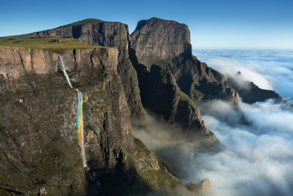
http://nicolasalexanderotto.net/der-landschaftsfotografie-podcast-s01-e20-alex-nail-english/
In the Royal Natal National Park, located in the province of KwaZulu-Natal, there is the Tugela Falls, the second highest in the world. Its waters fall from the eastern cliff of the Drakensberg Mountains in five cascades, the total height of which is 948 meters (the largest cascade is 411 m high, the maximum width is 15 m). In addition to its beauty, the waterfall is surprising in that during the rainy season, the volume of water in it can change dramatically (from 50 to 400 cubic meters / sec.). And in winter, the slope from which the waterfall falls can be covered with snow.
The waterfall is fed by the 512 m long river of the same name, which originates in the mountains.
Millions of travelers each year strive to see firsthand the splendor of one of South Africa's most impressive landmarks.
Location: Royal Natal National Park, KwaZulu-Natal, South Africa
Coordinates: 28°45′00″S, 28°53′45″E
Boulders Beach
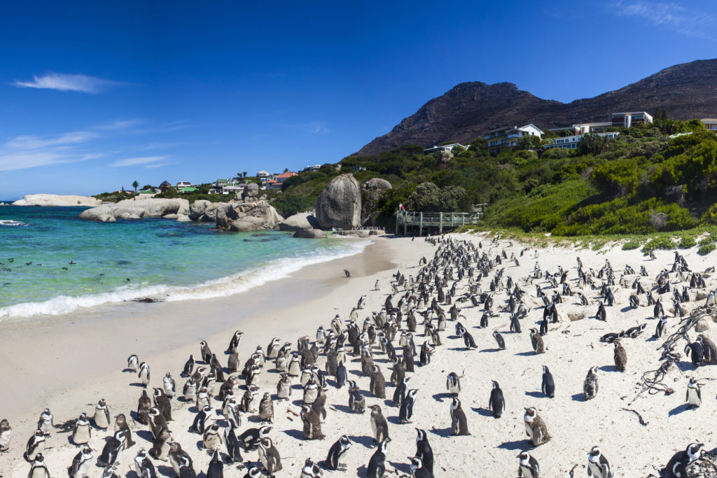
https://blog.virginatlantic.com/cape-town-were-heading-back-and-heres-why-you-should-too/
Wild Boulders Beach is located on the Cape Peninsula in Falls Bay, near Simons Town (a suburb of Cape Town). The place is unique for its inhabitants: African (spectacled) penguins, who settled on a deserted beach in 1982. This endangered penguin is under the protection and patronage of Table Mountain National Park (Table Mountain). Currently, the colony of penguins already numbers 3000 individuals: the hot climate has made possible year-round reproduction and the number of penguins is growing.
Comfortable living conditions for penguins are created by the cold Bengal current from Antarctica.
The beach stretches over several rocky coves surrounded by rocky shores. The huge granite boulders that gave the name to the beach form caves and create a unique scenic view. Access to the beach area is limited. Visitors to the reserve can observe birds in their natural habitat, standing on purpose-built wooden viewing platforms.
Every year more than 60 thousand visitors come to see the penguins, as it is not so easy to get to other habitats of these birds.
Location: Boulders Beach, 1 Kleintuin Rd, Cape Town, 7995, South Africa
Coordinates: 34°11′49″S, 18°27′04″E
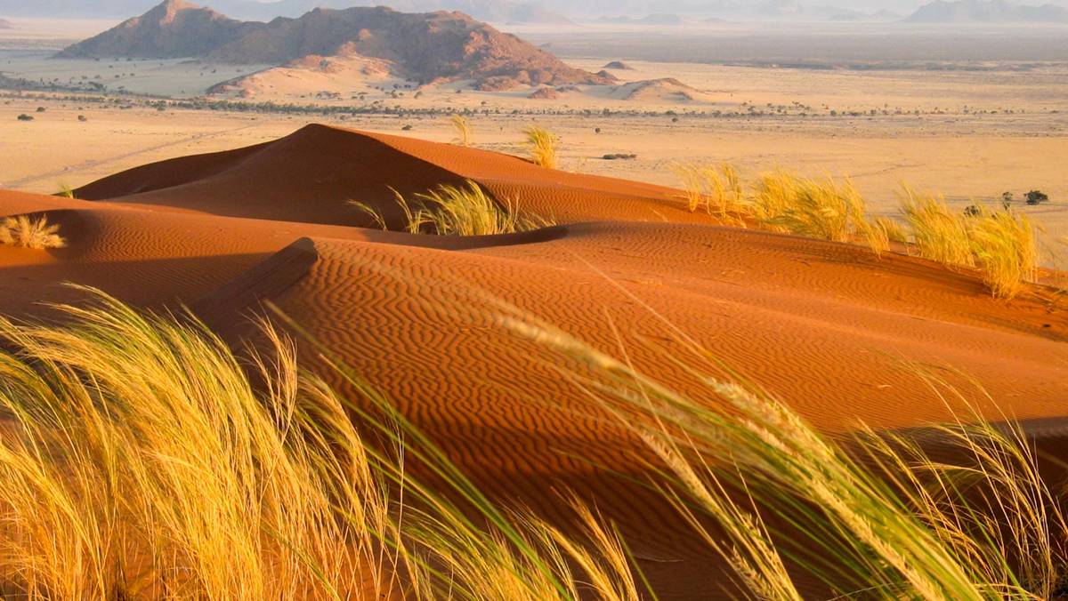
Kalahari Desert
https://www.african-safari-tour.com/tour/namibia-safari-tour/
The Kalahari Desert is the greatest natural monument on our planet, which is about 65 million years old. The Kalahari is the largest of the deserts of South Africa, part of which covers a large territory of the state of South Africa. The Kalahari area today is about 600 thousand km², but it is an ever-growing desert that is constantly conquering new territory for itself.
The entire territory of the Kalahari is a chain of sand dunes composed of Cenozoic sediments, mainly fine-grained red sands.
The sparse vegetation is represented by shrubs and grasses, as well as the umbrella acacia. The desert sands are home to 46 species of mammals.
The Kalahari has its own unique atmosphere: it is one of the hottest regions in South Africa (average temperatures + 12 ... .. + 29).
The indigenous population is the Bushmen (today their number is about 55,000). Only 2 thousand Bushmen have preserved their traditional way of life and are engaged in gathering and hunting. Farming and animal husbandry, which have just begun to develop, may not withstand the harsh environmental conditions.
The Kalahari has large reserves of water, but they are all at great depths (about 300 m).
Tourists from all over the world do not miss the opportunity to enjoy the endless expanses of the Kalahari and take an unforgettable journey through the famous red sands.
Coordinates: 23°S, 22°E
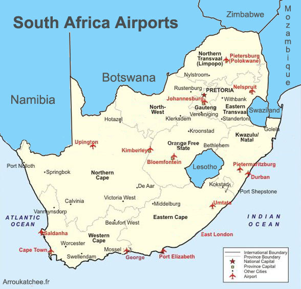
Major airports in South Africa
Among the large number of airlines in South Africa, South African Airways (SAA) is the largest airline in the country. It serves both international (flights to 32 countries of the world) and domestic flights (more than 600 per week).
224 airports are officially registered (including helipads). 3 international airports: in the cities of Durban, Johannesburg and Cape Town. A wide network of domestic transportation.
|
|
|
|
|
|
|
|
|
http://www.arroukatchee.fr/eng/plane-tickets.htm
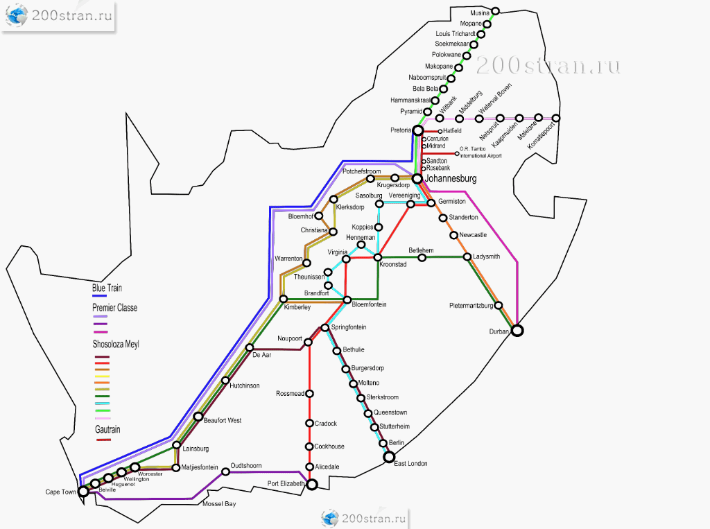
Major train stations in South Africa
The state-owned South African railroad is the most developed network in the entire African continent. Today the total length of the railway line is about 21 thousand km. The railway network is fully computerized. Trains connect all major cities and are a comfortable way to travel. But the fare is quite high, and whites should refrain from traveling as it is unsafe for them.
The commuter train network is huge.
Rovos Rail and Blue Train service the Tshwane: Cape Town route and are among the most comfortable in the world.
|
|
|
|
|
|
http://www.200stran.ru/maps_group26_item759.html
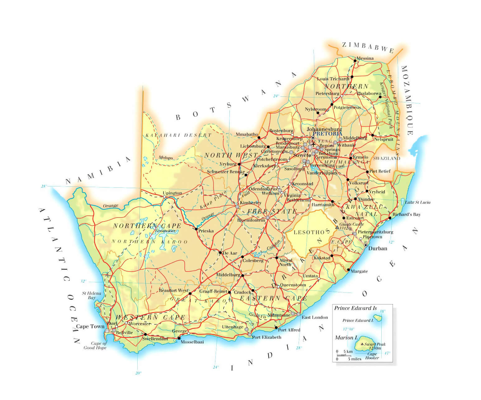
Highways of South Africa
The total length of highways in South Africa is more than 275 thousand km (with a hard surface of 57 thousand km, of which 2 thousand km are expressways). The motorway network is well thought out and developed throughout the country. 90% of the roads are electrified. The tracks are of good quality, usually six lanes. The absence of traffic jams guarantees fast movement. Roads are mostly toll, with the exception of free bypass roads. A feature of South African roads is a large number of clear road signs that make it easy to navigate.
Comfortable buses and minibuses are a popular and affordable form of public transport. Taxi call is carried out only by phone (voting is not accepted and unsafe).
80% of all domestic traffic is by road.
Route 1 is South Africa's national road from Cape Town to the Beit Bridge border post on the border with Zimbabwe. The length of this busy road is 1940 km.
The Chapman's Peak Drive toll road was built in 1922 and was an unsurpassed masterpiece of engineering of the time: 115 bends along dangerous cliffs overhanging the ocean. It is a mountain road on the western side of the Cape Peninsula near Cape Town.
https://www.maps-of-the-world.ru/africa/republic-of-south-africa/large-elevation-map-of-south-africa-with-roads-railroads-cities-and-airports
Editor's Choice: Apartheid Museum
https://artyom.co/johannesburg-plane/
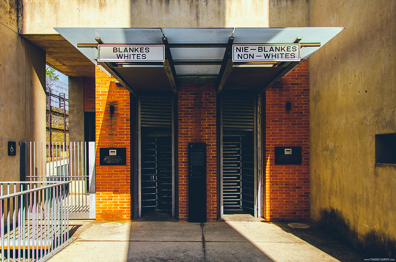
In 2001, a unique museum dedicated to the apartheid system that dominated South Africa in the 20th century (1948 - 1994). It was opened in the center of Johannesburg. Half a century of racial discrimination is part of South African history and is remembered in numerous documents, photographs, archival letters, subjects related to the life of political prisoners, instruments of torture.
The museum is equipped with an interactive exposition and modern displays.
The monolithic architecture of the museum building contrasts sharply against the backdrop of the Gold Reef City amusement park. Separate ticket offices for "whites" and "blacks", two entrances. From the very beginning, the atmosphere of the museum plunges into the atmosphere of the apartheid regime.
22 exhibition halls, which showcase life in South Africa during a time of racial segregation, when black South Africans were disenfranchised. The first exhibition is located in the courtyard. The seven pillars of the Constitution, written on the columns (democracy, equality, reconciliation, diversity, responsibility, respect and freedom). The most impressive of the halls is the Political Execution Hall, with hanging loops symbolizing numerous deaths. And on the way to the museum building there is an exposition with large photographs of descendants of immigrants who once came to the gold mines in Johannesburg.
The museum regularly hosts thematic exhibitions.
There is a lot of symbolism in the museum and the emotionally intense tour ends in a garden of astonishing beauty.
Adjacent to the museum is Constitution Hill, a former prison and fort that housed the famous apartheid resistance leader Nelson Mandela.
Location: Northern Park Way and Gold Reef Rd, Johannesburg, South Africa
Coordinates: 26°14′17″S, 28°00′32″E