USA map

https://blog.healthjobsnationwide.com/pt-supported-opioid-bill-ready-presidents-signature/
The United States of America is a leading power in the modern world, an economic and political leader, a country that influences most of the socio-economic processes on Earth. The US economy is in first place in the world in terms of nominal GDP ($ 21.2 trillion and $ 54.5 thousand per capita). It is believed that about 40% of the world's total wealth belongs to the people of the United States.
The United States covers an area of 9.4 million km² (fourth place in the world) on the North American continent. Population 329 million (third in the world). The average density is 34.6 people per km². The capital is Washington.
The United States is a federal presidential republic consisting of 50 states and the Federal District of Columbia.
The official language is American English.
There are few common land borders: Canada (in the north) and Mexico (in the south). Washed in the east by the Atlantic Ocean, from the west by the Pacific Ocean, and from the north by the Arctic Ocean.
Due to the large size and location of the country, the climate and weather of the United States is very diverse and covers almost any climatic condition:
- most of the country is in the temperate zone;
- the southern part of the country has a subtropical climate;
- the Hawaiian Islands and part of Florida have a tropical climate;
- there are semi-deserts and a Mediterranean climate.
In the United States, more than 50 territories have the status of national parks, and are protected from human influence. Through the creation of these sites, tourists from all over the world can see the natural habitat of wildlife in the United States, and appreciate how diverse America's nature is.
The country can offer very interesting and varied opportunities for tourists with different incomes. Excursion, beach holidays, ski resorts, the unique nature of the American continent, historical places for the United States, and much more. A big plus is the fact that with the same American visa you can visit Mexico, Albania, Bermuda, Turks and Caicos.
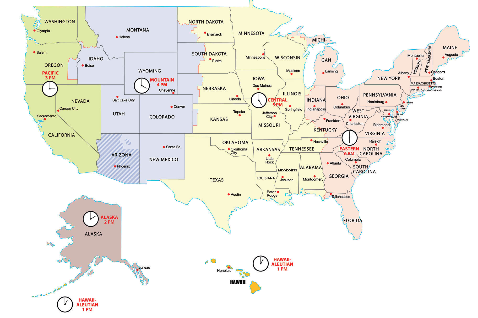
The United States is divided into 6 time zones, from UTC-10 to UTC-5, and there is daylight saving time in most of the country (except for Hawaii and parts of Arizona).
Regions of the USA
The United States consists of 50 states.
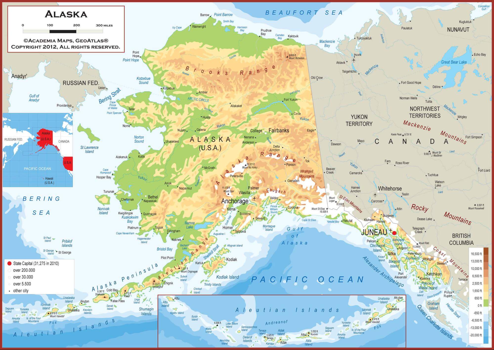
Alaska
The largest state in the USA, and the most northerly. It has a land border with Canada and a water border with Russia. The area of the state is 1.7 million km, and the population is more than 700 thousand people.
https://wallpapertag.com/us-map-wallpaper
There are over-state classifications of the United States into regions that are also widely used. According to the classification of the US Census Bureau, the country is divided into 4 regions:
- Northeastern USA
This includes the following states: Vermont, Connecticut, Massachusetts, Maine, New Hampshire, Rhode Island, New Jersey, New York, Pennsylvania.
- Midwest USA
Consists of the following states: Wisconsin, Illinois, Indiana, Michigan, Ohio, Iowa, Kansas, Minnesota, Missouri, Nebraska, North Dakota, South Dakota.
- South USA
This region contains the states: Virginia, Delaware, Georgia, West Virginia, Maryland, North Carolina, Florida, South Carolina, District of Columbia, Alabama, Kentucky, Mississippi, Tennessee, Arkansas, Louisiana, Oklahoma, and Texas. - West USA
Western Region states are as follows: Idaho, Arizona, Wyoming, Colorado, Montana, Nevada, New Mexico, Utah, Alaska, Washington, Hawaii, California, and Oregon.
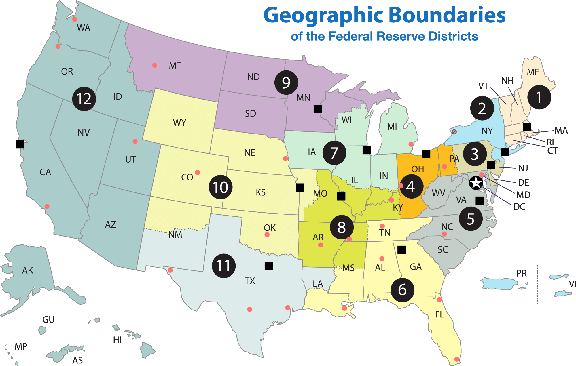
Other regional divisions of the country are based on a practical need for any institutional needs: the classification of the Federal Reserve System divides the United States into regions according to the location of the regional branches of the FRS on their territory. These are regions with the cities of Atlanta, Boston, Dallas, Kansas City, Cleveland, Minneapolis, New York.
https://www.kesslercompanies.com/
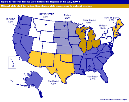
The US Bureau of Economic Analysis defines regions for comparing economic data, and they look like this:
New England, Middle East, Great Lakes, Plains, Southeast, Southwest, Rocky Mountains, Far West.
http://www.incontext.indiana.edu
Other regional divisions are based on time zones. There are 9 such regions: American Samoa / Hawaii / Alaska / Guam and the Northern Mariana Islands. And:
- Pacific time
- North American Mountain Time
- North American Central Time
- North American Eastern Time
- Atlantic time
https://nypost.com/
The most interesting sights of USA
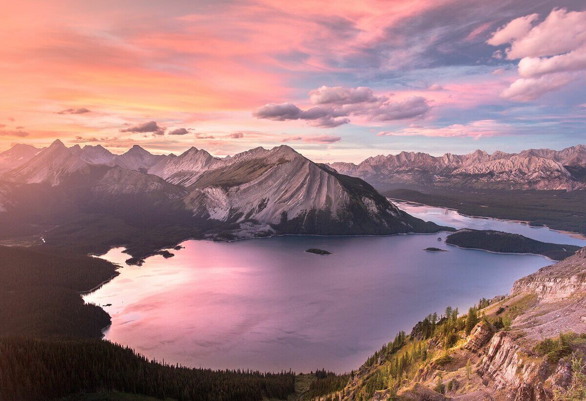
Great Lakes
https://1baikal.ru/puteshestviya/ozyora-zemli-s-solyu-bez-soli-i-dlya-samykh-smelykh
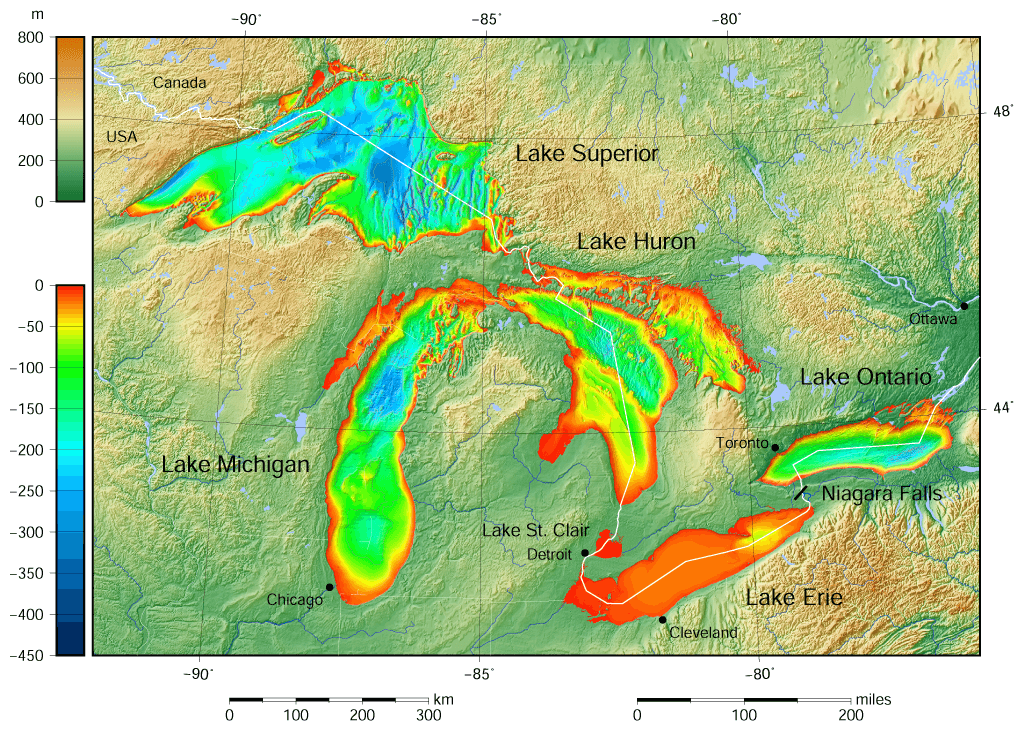
The world's largest group of freshwater lakes, ⅔ of which are located in the USA, and ⅓ are in Canada (total area 244 106 km², total volume 22 671 km³). The lakes were formed as a result of tectonic processes. The group includes five large lakes: Superior, Huron, Michigan, Ontario and Erie. This is 21% of the world and 84% of North America's total fresh water reserves.
Picturesque lakes form a single water system, as they are all connected by canals and rivers. The length of the coastline, including the coastline of the islands, is about 18 thousand km. The basin area is 768 thousand km² (including the area of the lakes themselves). Many small rivers flow into the lakes, but the water flows only through one large one. It is the St. Lawrence River, which carries it’s waters into the Atlantic Ocean.
The deepest and largest in area is Lake Superior: its area is 82.4 km², and the depth reaches 406 m. The smallest lake in the Great Lakes system is Lake St. Clair.
https://en.wikipedia.org/
More than 35 thousand islands are scattered across the lakes. Manitoulin Island is the largest island in the world located in a freshwater lake.
Wild forests, untouched by man, a variety of flora and fauna make this corner of the earth a real treasure, arousing the interest of millions of tourists who would like to feel the atmosphere of pristine nature.
Autumn is considered the best weather in the Great Lakes region, including a two-week Indian summer with dry and clear weather.
Coordinates: 45°N, 84°W
Grand Canyon
 https://weheartit.com/ragnhildtonstad/collections/11429670-verden
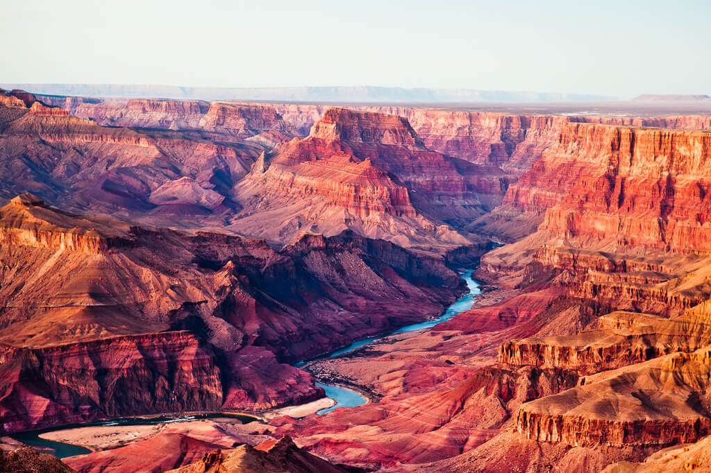
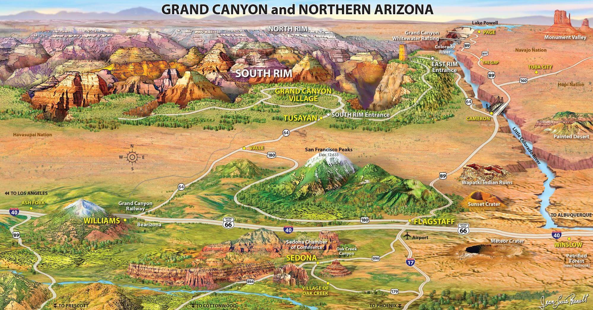
The Grand Canyon is one of the deepest canyons in the world. The Grand Canyon is located on the Colorado Plateau in Arizona in the Grand Canyon National Natural Park.
Since 1979, this unique geological site of the planet has been included in the UNESCO World Heritage List. The deep crevice was formed by the Colorado River about 5-6 million years ago and is considered one of the exemplary examples of erosional activity. The length of the canyon is 446 km, the width at the plateau level is from 6 to 29 km (at the bottom less than 1 km), the depth reaches 1857 meters.
The "walls" of the Grand Canyon are able to tell the story of the four geological eras of the Earth, and numerous rocks and caves contain rich material for research.
More than 4 million people come to see this miracle of nature every year. The stunning scale of this gorge and the palette of natural colors leave no one indifferent. There are hiking trails along the edge of the canyon, and one of the most beautiful places on earth is equipped with convenient viewing platforms. In 2007, the Grand Canyon SkyWalk was opened: the world's first glass bridge at an altitude of 1200 m in the form of a horseshoe, the extreme point of which is located above the abyss 20 meters from the edge of the plateau and from which an unforgettable view of the beauty of the Grand Canyon opens.
http://tournavigator.net/
Location: Colorado Plateau, State of Arizona, USA
Coordinates: 36°05′26″N, 113°14′23″W
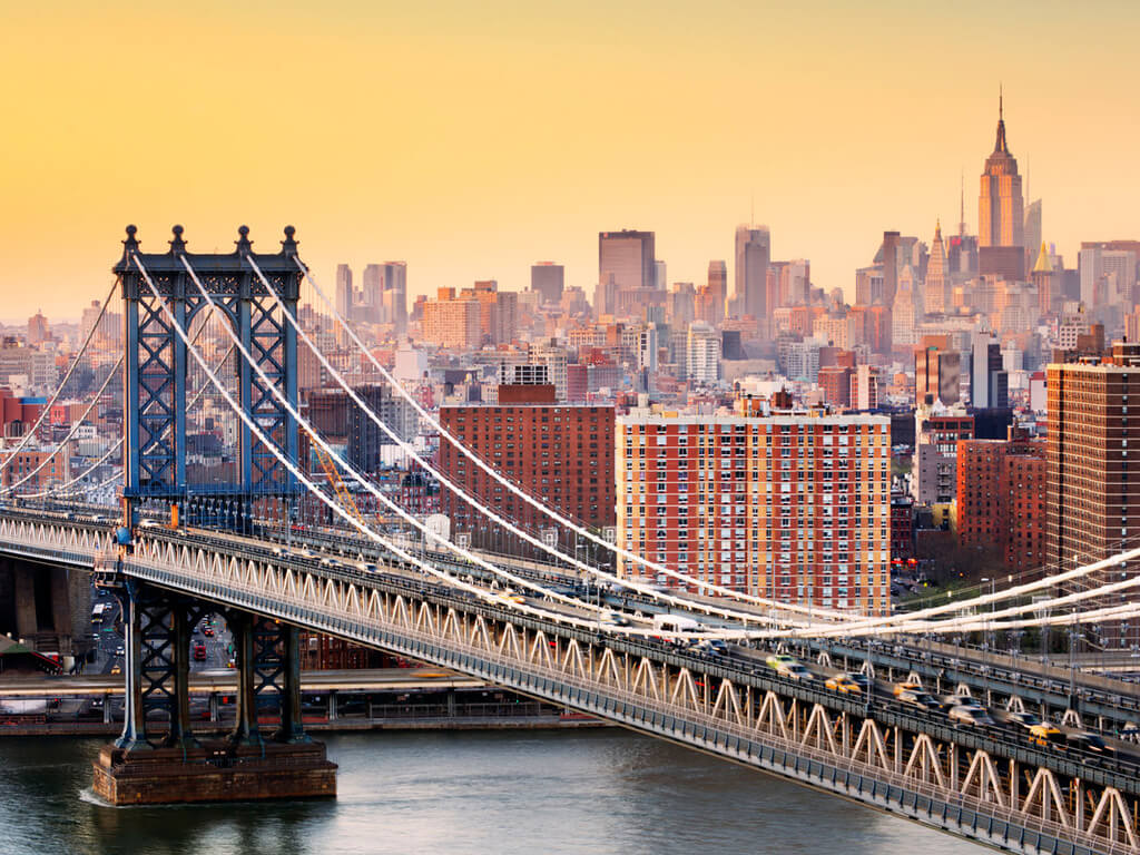
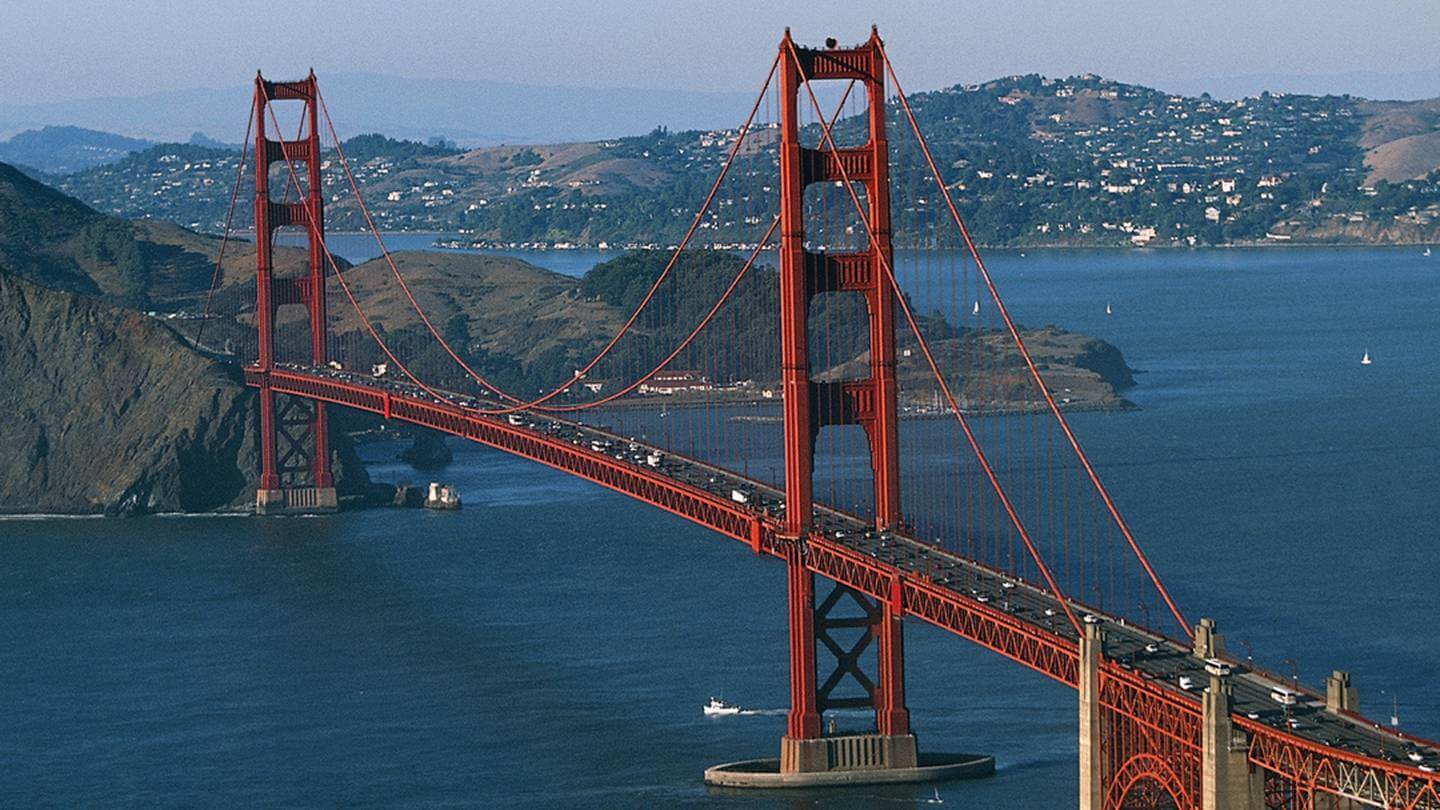
Brooklyn Bridge (New York City). Golden Gate Bridge (San Francisco).
https://www.nastol.com.ua/download/282566/1024x768/
The Brooklyn Bridge is one of the oldest suspension bridges in the world, connecting the New York districts of Brooklyn and Manhattan. Talk about the need for such a bridge has been going on since 1800, since the only way to get around was by ferries.
At the time of its opening in 1883, it was the longest suspension bridge on the planet (length 1833.7 m; width 25.9 m; span 486.3).
The bridge was designed by designer John August Roebling using a hybrid cable-stayed / suspended structure. The two stone towers of the bridge (85 meters high) made of limestone, granite and cement in the neo-Gothic style are decorated with pointed arches. The towers are supported by caissons made of southern yellow pine. Quite large rooms in caissons were once used by builders and rented out as storage facilities.
The complex construction of the bridge took 30 years. John Roebling, as the chief engineer, himself was very actively involved in the construction, and during one of the studies he received a leg injury, after which he soon died.
The case was continued by his son Washington Roebling, who also suffered during the implementation of the ambitious project. Decompression sickness and subsequent paralysis, chained him to bed for many years. Washington's wife Emily took up her husband's activities and for the next 11 years led the construction, having mastered higher mathematics, strength of materials and other sciences, which allowed her to take on the role of chief engineer. Emily Roebling was the first to cross the bridge.
Today, the Brooklyn Bridge is a National Historic Landmark. Six-lane traffic is only permitted for passenger cars. A complex system of ramps with access to the embankment is provided for pedestrians.
This romantic place attracts millions of tourists. Despite the prohibitions, lovers from all over the world come to the Brooklyn Bridge to leave their lock of love as a symbol of fidelity.
Location: New York City (Civic Center, Manhattan – Dumbo/Brooklyn Heights, Brooklyn), USA
Coordinates: 40°42′21″N, 73°59′48″W
https://www.nzherald.co.nz/sport/where-in-the-world-super-rugby-could-expand-to/CRWBM6XXMLRMB5OTM6UWB7FGEU/
The Golden Gate Bridge was opened in 1937, and until 1964 it retained the primacy as the world's largest suspension bridge. It is built across the Golden Gate and connects the city of San Francisco with southern Marin County.
Main characteristics:
- length 2737 m,
- main span - 1280 m,
- weight 894.5 tons,
- support height - 227 m.
Construction lasted only 4 years. The building is designed in an Art Deco style with smooth, elegant lines. The hallmark of the Golden Gate is not only the shape, but also the colour that is unusual for bridges. The American architect Irving Foster Morrow, who is part of the Golden Gate design team, found the unique International Orange color and also developed the most optimal lighting scheme.
Today, the Golden Gate Bridge is one of the most recognizable and impressive bridges in the world. More than 10 million visitors come to see the miracle of engineering every year. About 110 thousand vehicles cross the bridge every day.
On the other hand, beyond the Golden Gate, there is a sad glory: the bridge is known as a popular place for suicide. The statistics are merciless: jumping from the bridge occurs on average once every 2 weeks. In order to somehow reduce the number of suicides, special telephones have been installed along the bridge, where potential suicides can contact the crisis counseling center. On the phones written: “There is hope. Make the call. The consequences of jumping from this bridge are fatal and tragic. "
Location: Golden Gate, San Francisco, State of California, USA
Coordinates: 37°49′03″N, 122°28′42″W
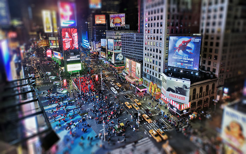
Times Square
https://buyhotels.ru/обзор-города-нью-йорк-сша/
Times Square is a famous New York square located in the center of Manhattan, which has become a symbol not only of the city, but of the entire United States. The square with a rich history attracts a huge number of guests every year. Statistics say that more than 50 million people come to the square every year to immerse themselves in the neon atmosphere of the “crossroads of the worlds,” as Times Square is often called. The square is located at the intersection of Broadway and Seventh Avenues between 42nd and 47th streets.
At different times, Times Square has been both a cultural center, and the most desirable place to live, and a criminal area, but invariably it was a place in which life is boiling. The always crowded square is a reflection of everything that happens in New York.
Times Square has:
- Theater quarter. Concert halls, cinemas, theaters, music halls
- Madame Tussauds museum. 200 wax figures of famous people of politics and show business from all over the world
- famous publishers
- shopping centers, boutiques
- restaurants, cafes, bars
- a unique living attraction. Street actor and singer Robert John Burke, the public favorite (has an official license confirming his right to register marriages)
Every day about 300 thousand people pass through it, 115 thousand cars pass through it.
Bright neon billboards and signs are a must-have attribute that creates a separate world in the center of a big city.
Location: at the junction of Broadway and Seventh Avenue, between 42nd and 47th Streets, Midtown Manhattan, NY, State of New York, USA
Coordinates: 40°45′21″N, 73°59′11″W
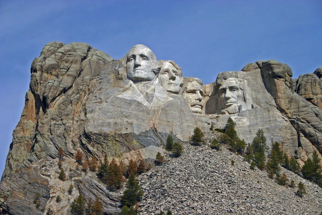
Mount Rushmore
https://ucrazy.ru/other/1414692409-lica-gory-rashmor.html
Mount Rushmore National Memorial is located in the Black Hills in South Dakota, southwest of Keyston, and covers an area of more than 517 hectares. The project is led by the US National Park Service.
The main attraction of the memorial is Mount Rushmore, which has a carved bas-relief dedicated to the four presidents of the United States: George Washington, Thomas Jefferson, Theodore Roosevelt, and Abraham Lincoln. The project of the talented sculptor Gutzon Borglum was aimed at perpetuating the contribution of these great people to the development of a huge country.
The height of the carved portraits is 18 meters. The idea took 14 years of hard work by 400 workers. In 1941, the memorial was inaugurated.
Attendance: 3 million people per year. For tourists there is a museum and a workshop dedicated to the sculptor and workers who carried out the grandiose idea, as well as a souvenir shop and a cafe.
Location: Mount Rushmore UT, State of South Dakota, USA
Coordinates: 43°52′44″N, 103°27′34″W
Major US airports
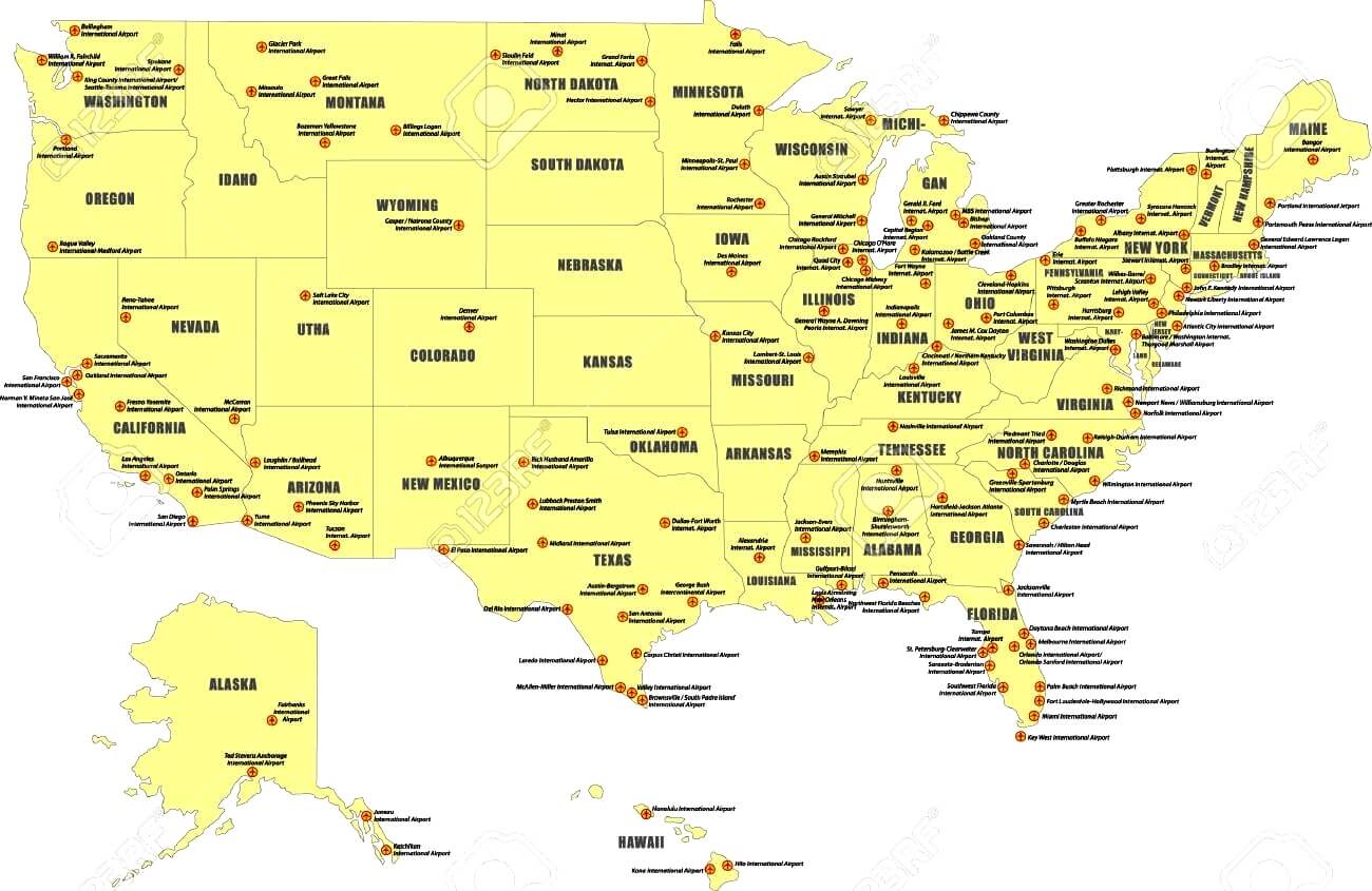
https://zagranportal.ru/ssha/transport-ssha/aeroporty-ssha.html
There are about 100 international airports in the United States, sixteen of which are in the World's 100 Best Airports ranking and fifteen are in the World's 50 Busiest Airports ranking. With such a large number of airports, and a huge number of carriers (more than 200 airlines), America is the world's leading airline.
Here are five of the biggest and most popular ones:
- Hartsfield-Jackson Atlanta International Airport.
The busiest airport in the world, recognized as the most efficient airport in the last 15 years. The average monthly passenger traffic is about 9 million passengers, about a million flights annually. Has its own metro station to facilitate transport accessibility.
Location: 6000 N Terminal Pkwy, Atlanta, GA 30320, USA
Coordinates: 33°38′12″N, 84°25′41″W
- Phoenix Sky Harbor International Airport
The largest airport in the state of Arizona, and one of the largest in the US Southwest. Has three parallel runways, operates around the clock. The passenger traffic is 40.6 million people per year.
Location: 3400 E Sky Harbor Blvd, Phoenix, AZ 85034, USA
Coordinates: 33°26′03″N, 112°00′42″W
- Charlotte Douglas International Airport
It occupies 24th place in the world in terms of the number of passengers carried, 4 runways, and passenger traffic of 39 million people per year. Works around the clock.
Location: 5501 Josh Birmingham Pkwy, Charlotte, NC 28208, USA
Coordinates: 35°12′50″N, 80°56′35″W
- Newark Liberty International Airport
Ranked fifth among US airports in terms of international traffic. International flights are served at two of the airport's three terminals: B and C. Terminal A has no customs control. Airport serves international flights to most countries of the world, passenger traffic is 35.4 million passengers per year.
Location: 3 Brewster Rd, Newark, NJ 07114, USA
Coordinates: 40°41′33″N, 74°10′07″W
- Philadelphia International Airport
The largest airport in Pennsylvania. It serves flights to the USA, Canada, the Middle East, Europe, Latin America, and the Caribbean islands. Passenger traffic is about 33 mil. passengers per year.
Location: 8000 Essington Ave, Philadelphia, PA 19153, USA
Coordinates: 42°21′32″N, 71°05′34″W
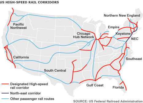
US Railways
 `
`
https://dtydaustin.wordpress.com/
The USA railway network has the largest length in the world: about 300 thousand km, all these roads are owned by private companies.
Freight rail transportation in the USA is recognized as the best in the world, as it has reached the highest rates among all countries: more than 40% of all freight traffic in the country is carried out by rail.
Important and basic cargo transported by rail are the following: coal, oil, chemical and agricultural products, container cargo.
Passenger transportation in the USA, with the growing popularity of road transport and air transportation, was in constant decline, which is why in the 70s a state-owned enterprise Amtrak (short for America and track) was created, subsidized by the government of the country (as the company is unprofitable). Private companies have refused to carry passengers.
Amtrak's annual passenger traffic is about 30 million passengers.
Due to the fact that passenger trains in the USA travel on railways designed for freight transport (and they are not designed for passenger comfort and for fast movement), there are problems in the United States with the launch of high-speed electric trains. Therefore, now high-speed rail transportation is not widespread in America.
But there is movement in this direction, money is being invested in the reconstruction of freight lines of railways, along which the American high-speed train Acela Express will be able to move. Now this train carries about 3 million passengers a year in the northeastern United States, from Washington to Boston via New York. And it competes with airplanes, serving about half of all passenger traffic between New York and Washington.
Highways USA
American roads are world famous for their quality, and are second only to the Chinese highway system in length. Highways in America are much more popular than, for example, rail transport.
American roads owe their quality to a special layer-by-layer technology with the use of concrete, which, although it requires large investments, allows the roads to be operated without repair for at least 25 years. Concrete roads last much longer.
In addition to a long service life, US roads are safe due to special measures taken during construction: separation from oncoming lanes, smooth turns, thoughtful entry and exit, etc.
More than half of the states have toll roads, while there are fewer toll roads in the west and south of the country. Typically, toll roads are built around or within large cities, and travel through long tunnels and bridges is also paid.
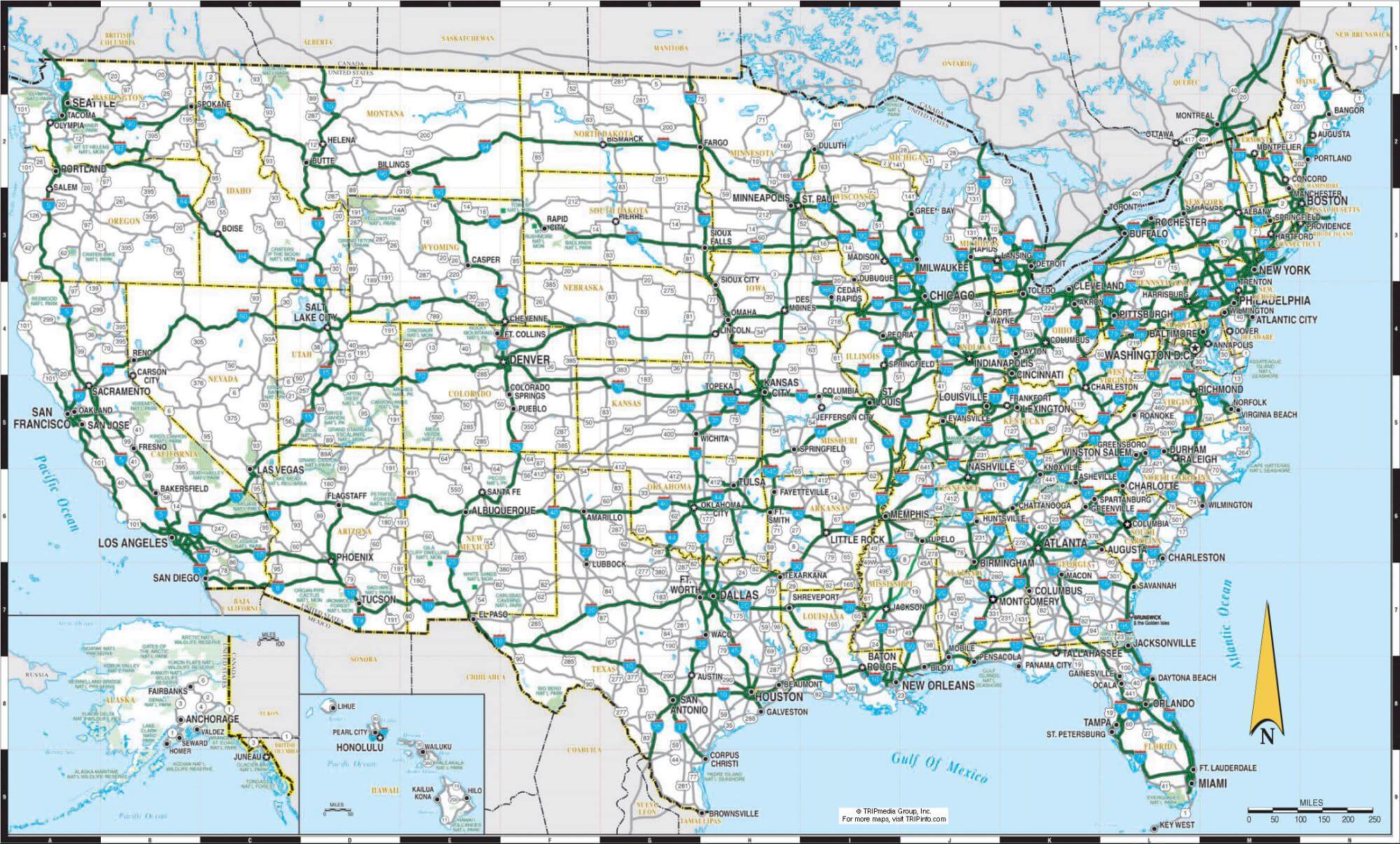
http://www.mapsfinder.ru/
Many travelers dream of driving along the legendary roads of the United States, visiting many of the attractions. Special maps will be useful for such events.
Travelers should be aware that car traffic in the United States is right-hand, and studded tires are prohibited in almost all states except some northern ones.
https://laughingsquid.com/
Editor's Choice: US Universities
http://rusobrazovanie.ru/
US universities are considered the most prestigious educational institutions in the world, as can be seen in the success ratings, where they are at the forefront and first places. Therefore, after receiving the education certificate of the United States, bright prospects open up in many countries of the world; although competition for admission, education costs and admission requirements can be challenging.
As a rule, three universities are in the first positions:
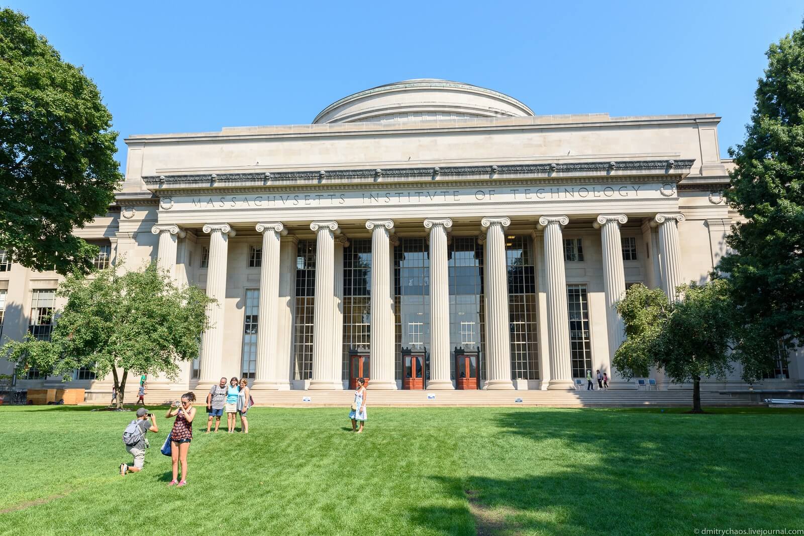
- Massachusetts Institute of Technology, MIT
One of it’s foremost competencies is in the field of robotics and artificial intelligence. MIT's educational programs in IT, physics, chemistry and mathematics are recognized as the best in the country. Has the largest number of Nobel laureates in the active members of the university community. Works closely with the US Air Force in the field of military research. The cost of training is from 55 thousand dollars per year.
Location: 77 Massachusetts Ave, Cambridge, MA 02139, United States
Coordinates: 42°21′32″N, 71°05′34″W
- Harvard University
The oldest educational institution in the United States. 75 Nobel laureates are somehow connected with this university; it ranks first in America for the number of billionaire graduates. 8 US presidents are Harvard alumni. Tuition at this university will cost from 30 to 74 thousand dollars a year.
Location: Cambridge, MA, United States
Coordinates: 42°22′34″N, 71°06′59″W
- Stanford University; Leland Stanford Junior University
A private research institute, one of the most prestigious in the world. 84 Nobel laureates are affiliated with Stanford. He was directly and closely involved in the founding and development of Silicon Valley. He is especially known for his education in the field of entrepreneurship, he is distinguished by his success in attracting investments for startups.
The average cost of training is $ 74.5 thousand per year. This amount can be reduced by receiving scholarships from an educational institution, grants from the state or state up to 12.2 thousand dollars (on average) per year.
Location:450 Serra Mall, Stanford, CA 94305, United States
Coordinates: 37°25′48″N, 122°10′12″W